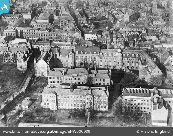
EPW000039 ENGLAND (1920). The Downing Site, Cambridge, 1920
© Copyright OpenStreetMap contributors and licensed by the OpenStreetMap Foundation. 2026. Cartography is licensed as CC BY-SA.
Nearby Images (22)
Details
| Title | [EPW000039] The Downing Site, Cambridge, 1920 |
| Reference | EPW000039 |
| Date | January-1920 |
| Link | |
| Place name | CAMBRIDGE |
| Parish | |
| District | |
| Country | ENGLAND |
| Easting / Northing | 545083, 258192 |
| Longitude / Latitude | 0.12326932961398, 52.202433326154 |
| National Grid Reference | TL451582 |
Pins

Peter Smith |
Friday 15th of March 2024 11:03:48 AM | |

Peter Smith |
Friday 15th of March 2024 11:03:32 AM | |

Peter Smith |
Friday 15th of March 2024 11:03:11 AM | |

Peter Smith |
Friday 15th of March 2024 11:03:00 AM |


![[EPW000039] The Downing Site, Cambridge, 1920](http://britainfromabove.org.uk/sites/all/libraries/aerofilms-images/public/100x100/EPW/000/EPW000039.jpg)
![[EPW000043] The Downing Site, Cambridge, 1920](http://britainfromabove.org.uk/sites/all/libraries/aerofilms-images/public/100x100/EPW/000/EPW000043.jpg)
![[EPW009780] The Downing Site, Cambridge, 1924](http://britainfromabove.org.uk/sites/all/libraries/aerofilms-images/public/100x100/EPW/009/EPW009780.jpg)
![[EPW025464] University buildings off Downing Street, Cambridge, 1928. This image has been produced from a copy-negative.](http://britainfromabove.org.uk/sites/all/libraries/aerofilms-images/public/100x100/EPW/025/EPW025464.jpg)
![[EPW009773] The Downing Site, Cambridge, 1924](http://britainfromabove.org.uk/sites/all/libraries/aerofilms-images/public/100x100/EPW/009/EPW009773.jpg)
![[EAW014114] Clare College, King's College and Queens' College, Cambridge, 1948](http://britainfromabove.org.uk/sites/all/libraries/aerofilms-images/public/100x100/EAW/014/EAW014114.jpg)
![[EPW009785] The Downing Site, Cambridge, 1924](http://britainfromabove.org.uk/sites/all/libraries/aerofilms-images/public/100x100/EPW/009/EPW009785.jpg)
![[EAW018200] Emmanuel College and environs, Cambridge, from the south-west, 1948. This image has been produced from a damaged negative.](http://britainfromabove.org.uk/sites/all/libraries/aerofilms-images/public/100x100/EAW/018/EAW018200.jpg)
![[EPW045938] Pembroke College, Cambridge, 1934](http://britainfromabove.org.uk/sites/all/libraries/aerofilms-images/public/100x100/EPW/045/EPW045938.jpg)
![[EPW045942] Cambridge Colleges, Cambridge, 1934](http://britainfromabove.org.uk/sites/all/libraries/aerofilms-images/public/100x100/EPW/045/EPW045942.jpg)
![[EPW045939] Pembroke College, Cambridge, 1934](http://britainfromabove.org.uk/sites/all/libraries/aerofilms-images/public/100x100/EPW/045/EPW045939.jpg)
![[EPW045941] Cambridge Colleges, Cambridge, 1934](http://britainfromabove.org.uk/sites/all/libraries/aerofilms-images/public/100x100/EPW/045/EPW045941.jpg)
![[EAW018198] Emmanuel College and environs, Cambridge, from the south-west, 1948. This image has been produced from a print marked by Aerofilms Ltd for photo editing.](http://britainfromabove.org.uk/sites/all/libraries/aerofilms-images/public/100x100/EAW/018/EAW018198.jpg)
![[EAW018201] Emmanuel College and environs, Cambridge, from the south-west, 1948. This image has been produced from a print marked by Aerofilms Ltd for photo editing.](http://britainfromabove.org.uk/sites/all/libraries/aerofilms-images/public/100x100/EAW/018/EAW018201.jpg)
![[EAW018199] Emmanuel College and environs, Cambridge, from the south-west, 1948. This image was marked by Aerofilms Ltd for photo editing.](http://britainfromabove.org.uk/sites/all/libraries/aerofilms-images/public/100x100/EAW/018/EAW018199.jpg)
![[EPW000047] Corpus Christi College and environs, Cambridge, 1920](http://britainfromabove.org.uk/sites/all/libraries/aerofilms-images/public/100x100/EPW/000/EPW000047.jpg)
![[EPW045940] Pembroke College, Cambridge, 1934](http://britainfromabove.org.uk/sites/all/libraries/aerofilms-images/public/100x100/EPW/045/EPW045940.jpg)
![[EAW018197] Emmanuel College and environs, Cambridge, 1948. This image has been produced from a print marked by Aerofilms Ltd for photo editing.](http://britainfromabove.org.uk/sites/all/libraries/aerofilms-images/public/100x100/EAW/018/EAW018197.jpg)
![[EAW018196] Emmanuel College and environs, Cambridge, 1948. This image has been produced from a print.](http://britainfromabove.org.uk/sites/all/libraries/aerofilms-images/public/100x100/EAW/018/EAW018196.jpg)
![[EPW000059] The Pitt Press, Cambridge, 1920](http://britainfromabove.org.uk/sites/all/libraries/aerofilms-images/public/100x100/EPW/000/EPW000059.jpg)
![[EAW018195] Emmanuel College and environs, Cambridge, 1948. This image has been produced from a print marked by Aerofilms Ltd for photo editing.](http://britainfromabove.org.uk/sites/all/libraries/aerofilms-images/public/100x100/EAW/018/EAW018195.jpg)
![[EPW059041] King's College First Court, the Guildhall and the city centre, Cambridge, 1938. This image has been produced from a damaged negative.](http://britainfromabove.org.uk/sites/all/libraries/aerofilms-images/public/100x100/EPW/059/EPW059041.jpg)