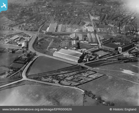
EPR000626 ENGLAND (1935). The British Insulated Cables Ltd Works and environs, Prescot, 1935
© Copyright OpenStreetMap contributors and licensed by the OpenStreetMap Foundation. 2026. Cartography is licensed as CC BY-SA.
Nearby Images (34)
Details
| Title | [EPR000626] The British Insulated Cables Ltd Works and environs, Prescot, 1935 |
| Reference | EPR000626 |
| Date | May-1935 |
| Link | |
| Place name | PRESCOT |
| Parish | PRESCOT |
| District | |
| Country | ENGLAND |
| Easting / Northing | 346834, 392146 |
| Longitude / Latitude | -2.8001463614909, 53.423168192473 |
| National Grid Reference | SJ468921 |
Pins
Be the first to add a comment to this image!


![[EPR000626] The British Insulated Cables Ltd Works and environs, Prescot, 1935](http://britainfromabove.org.uk/sites/all/libraries/aerofilms-images/public/100x100/EPR/000/EPR000626.jpg)
![[EPW054343] The British Insulated Cable Works, Prescot, 1937](http://britainfromabove.org.uk/sites/all/libraries/aerofilms-images/public/100x100/EPW/054/EPW054343.jpg)
![[EPR000625] The British Insulated Cables Ltd Works, Prescot, 1935](http://britainfromabove.org.uk/sites/all/libraries/aerofilms-images/public/100x100/EPR/000/EPR000625.jpg)
![[EAW021941] The town, Prescot, 1949. This image was marked by Aerofilms Ltd for photo editing.](http://britainfromabove.org.uk/sites/all/libraries/aerofilms-images/public/100x100/EAW/021/EAW021941.jpg)
![[EAW017346] The British Insulated Callender's Cable Works, Prescot, from the east, 1948. This image has been produced from a print.](http://britainfromabove.org.uk/sites/all/libraries/aerofilms-images/public/100x100/EAW/017/EAW017346.jpg)
![[EPW026181] The British Insulated Cable Works and the town, Prescot, 1929](http://britainfromabove.org.uk/sites/all/libraries/aerofilms-images/public/100x100/EPW/026/EPW026181.jpg)
![[EAW017345] The British Insulated Callender's Cable Works, Prescot, 1948. This image has been produced from a print.](http://britainfromabove.org.uk/sites/all/libraries/aerofilms-images/public/100x100/EAW/017/EAW017345.jpg)
![[EPW026180] The British Insulated Cable Works, Prescot, 1929](http://britainfromabove.org.uk/sites/all/libraries/aerofilms-images/public/100x100/EPW/026/EPW026180.jpg)
![[EPW014159] The British Insulated Cable Works and Prescot Railway Station, Prescot, 1925. This image has been produced from a copy-negative.](http://britainfromabove.org.uk/sites/all/libraries/aerofilms-images/public/100x100/EPW/014/EPW014159.jpg)
![[EPW027865] The British Insulated Cable Works and the town, Prescot, 1929. This image has been produced from a damaged negative.](http://britainfromabove.org.uk/sites/all/libraries/aerofilms-images/public/100x100/EPW/027/EPW027865.jpg)
![[EPW025351] British Insulated Cable Works, Prescot, 1928](http://britainfromabove.org.uk/sites/all/libraries/aerofilms-images/public/100x100/EPW/025/EPW025351.jpg)
![[EPW025352] British Insulated Cable Works, Prescot, 1928](http://britainfromabove.org.uk/sites/all/libraries/aerofilms-images/public/100x100/EPW/025/EPW025352.jpg)
![[EPW054342] The British Insulated Cable Works, Prescot, 1937](http://britainfromabove.org.uk/sites/all/libraries/aerofilms-images/public/100x100/EPW/054/EPW054342.jpg)
![[EPW026182] The British Insulated Cable Works and the town, Prescot, 1929](http://britainfromabove.org.uk/sites/all/libraries/aerofilms-images/public/100x100/EPW/026/EPW026182.jpg)
![[EPW027866] The British Insulated Cable Works and the town, Prescot, 1929. This image has been produced from a damaged negative.](http://britainfromabove.org.uk/sites/all/libraries/aerofilms-images/public/100x100/EPW/027/EPW027866.jpg)
![[EAW021945] British Insulated Callender's Cable Works and environs, Prescot, 1949. This image was marked by Aerofilms Ltd for photo editing.](http://britainfromabove.org.uk/sites/all/libraries/aerofilms-images/public/100x100/EAW/021/EAW021945.jpg)
![[EAW021947] British Insulated Callender's Cable Works, Prescot, 1949](http://britainfromabove.org.uk/sites/all/libraries/aerofilms-images/public/100x100/EAW/021/EAW021947.jpg)
![[EPW026179] The British Insulated Cable Works and the town, Prescot, 1929](http://britainfromabove.org.uk/sites/all/libraries/aerofilms-images/public/100x100/EPW/026/EPW026179.jpg)
![[EPW026176] The British Insulated Cable Works and the town, Prescot, from the south-west, 1929](http://britainfromabove.org.uk/sites/all/libraries/aerofilms-images/public/100x100/EPW/026/EPW026176.jpg)
![[EAW021942] British Insulated Callender's Cable Works, Prescot, 1949](http://britainfromabove.org.uk/sites/all/libraries/aerofilms-images/public/100x100/EAW/021/EAW021942.jpg)
![[EPW027864] The British Insulated Cable Works and the town, Prescot, 1929. This image has been affected by flare.](http://britainfromabove.org.uk/sites/all/libraries/aerofilms-images/public/100x100/EPW/027/EPW027864.jpg)
![[EPW053284] The British Insulated Cable Works, Prescot, 1937](http://britainfromabove.org.uk/sites/all/libraries/aerofilms-images/public/100x100/EPW/053/EPW053284.jpg)
![[EPW053286] The British Insulated Cable Works, Prescot, 1937](http://britainfromabove.org.uk/sites/all/libraries/aerofilms-images/public/100x100/EPW/053/EPW053286.jpg)
![[EPW053287] The British Insulated Cable Works, Prescot, 1937](http://britainfromabove.org.uk/sites/all/libraries/aerofilms-images/public/100x100/EPW/053/EPW053287.jpg)
![[EPW053288] The British Insulated Cable Works, Prescot, 1937](http://britainfromabove.org.uk/sites/all/libraries/aerofilms-images/public/100x100/EPW/053/EPW053288.jpg)
![[EAW021944] British Insulated Callender's Cable Works, Prescot, 1949. This image was marked by Aerofilms Ltd for photo editing.](http://britainfromabove.org.uk/sites/all/libraries/aerofilms-images/public/100x100/EAW/021/EAW021944.jpg)
![[EAW021948] British Insulated Callender's Cable Works, Prescot, 1949](http://britainfromabove.org.uk/sites/all/libraries/aerofilms-images/public/100x100/EAW/021/EAW021948.jpg)
![[EAW017351] The British Insulated Callender's Cable Works and environs, Prescot, 1948. This image has been produced from a print.](http://britainfromabove.org.uk/sites/all/libraries/aerofilms-images/public/100x100/EAW/017/EAW017351.jpg)
![[EAW021951] British Insulated Callender's Cable Works and the town, Prescot, 1949](http://britainfromabove.org.uk/sites/all/libraries/aerofilms-images/public/100x100/EAW/021/EAW021951.jpg)
![[EAW021943] British Insulated Callender's Cable Works, Prescot, 1949. This image was marked by Aerofilms Ltd for photo editing.](http://britainfromabove.org.uk/sites/all/libraries/aerofilms-images/public/100x100/EAW/021/EAW021943.jpg)
![[EPW025208] British Insulated Cable Works and environs, Prescot, 1928](http://britainfromabove.org.uk/sites/all/libraries/aerofilms-images/public/100x100/EPW/025/EPW025208.jpg)
![[EPW026178] The British Insulated Cable Works and the town, Prescot, 1929](http://britainfromabove.org.uk/sites/all/libraries/aerofilms-images/public/100x100/EPW/026/EPW026178.jpg)
![[EPR000627] The British Insulated Cables Ltd Works and environs, Prescot, 1935](http://britainfromabove.org.uk/sites/all/libraries/aerofilms-images/public/100x100/EPR/000/EPR000627.jpg)
![[EAW017344] The British Insulated Callender's Cable Works, Prescot, from the east, 1948. This image has been produced from a print.](http://britainfromabove.org.uk/sites/all/libraries/aerofilms-images/public/100x100/EAW/017/EAW017344.jpg)