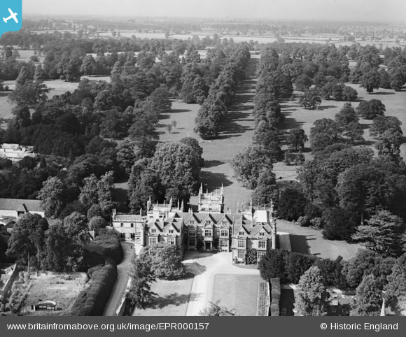
EPR000157 ENGLAND (1934). Corsham Court and Park, Corsham, from the south, 1934
© Copyright OpenStreetMap contributors and licensed by the OpenStreetMap Foundation. 2026. Cartography is licensed as CC BY-SA.
Nearby Images (6)
Details
| Title | [EPR000157] Corsham Court and Park, Corsham, from the south, 1934 |
| Reference | EPR000157 |
| Date | July-1934 |
| Link | |
| Place name | CORSHAM |
| Parish | CORSHAM |
| District | |
| Country | ENGLAND |
| Easting / Northing | 387411, 170676 |
| Longitude / Latitude | -2.1811221786359, 51.434452611315 |
| National Grid Reference | ST874707 |
Pins
Be the first to add a comment to this image!


![[EPR000157] Corsham Court and Park, Corsham, from the south, 1934](http://britainfromabove.org.uk/sites/all/libraries/aerofilms-images/public/100x100/EPR/000/EPR000157.jpg)
![[EPW033508] Corsham Court, Corsham, 1930](http://britainfromabove.org.uk/sites/all/libraries/aerofilms-images/public/100x100/EPW/033/EPW033508.jpg)
![[EAW028644] Priory Street, Corsham Court and Corsham Park, Corsham, 1950. This image was marked by Aerofilms Ltd for photo editing.](http://britainfromabove.org.uk/sites/all/libraries/aerofilms-images/public/100x100/EAW/028/EAW028644.jpg)
![[EAW028640] Corsham Court and environs, Corsham, 1950](http://britainfromabove.org.uk/sites/all/libraries/aerofilms-images/public/100x100/EAW/028/EAW028640.jpg)
![[EAW028639] Corsham Court, St Bartholomew's Church and the town, Corsham, 1950](http://britainfromabove.org.uk/sites/all/libraries/aerofilms-images/public/100x100/EAW/028/EAW028639.jpg)
![[EPW033514] The High Street, Corsham, 1930](http://britainfromabove.org.uk/sites/all/libraries/aerofilms-images/public/100x100/EPW/033/EPW033514.jpg)