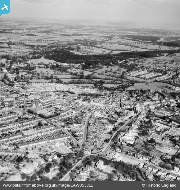
EAW053311 ENGLAND (1954). High Barnet and Monken Hadley Common, Barnet, from the south-west, 1954
    © Copyright OpenStreetMap contributors and licensed by the OpenStreetMap Foundation. 2025. Cartography is licensed as CC BY-SA.
  
Nearby Images (7)
Details
| Title | [EAW053311] High Barnet and Monken Hadley Common, Barnet, from the south-west, 1954 | 
| Reference | EAW053311 | 
| Date | 29-March-1954 | 
| Link | |
| Place name | BARNET | 
| Parish | |
| District | |
| Country | ENGLAND | 
| Easting / Northing | 524290, 196521 | 
| Longitude / Latitude | -0.20313420160714, 51.653255188225 | 
| National Grid Reference | TQ243965 | 
Pins
|  Union Street. |   Downloader141 | Wednesday 20th of March 2024 11:16:36 AM | 
|  The Crown & Anchor (now permanently closed). Fascia sign still showing 2023. |   Downloader141 | Wednesday 20th of March 2024 11:13:52 AM | 
|  The Bull pub (now a theatre) |   Downloader141 | Wednesday 20th of March 2024 10:55:00 AM | 
|   Downloader141 | Wednesday 20th of March 2024 10:53:19 AM | |
|  St John The Baptist Church, Chipping Barnet (at top of Barnet Hill) |   Downloader141 | Wednesday 20th of March 2024 10:36:04 AM | 
|  CIVIL AIR RAID SHELTER: e70968 |   Matt Aldred edob.mattaldred.com | Thursday 7th of March 2024 01:26:34 PM | 
 
             
  ![[EAW053311] High Barnet and Monken Hadley Common, Barnet, from the south-west, 1954](http://britainfromabove.org.uk/sites/all/libraries/aerofilms-images/public/100x100/EAW/053/EAW053311.jpg) 
  
                                          ![[EPW025446] The Cottage Hospital and Congergational Chapel on Wood Street, Barnet, 1928](http://britainfromabove.org.uk/sites/all/libraries/aerofilms-images/public/100x100/EPW/025/EPW025446.jpg) 
 ![[EPW001544] General view of the town centre, Chipping Barnet, from the south-west, 1920](http://britainfromabove.org.uk/sites/all/libraries/aerofilms-images/public/100x100/EPW/001/EPW001544.jpg) 
 ![[EPW013420] The High Street, Bruce Road and Salisbury Road, High Barnet, 1925. This image has been produced from a copy-negative.](http://britainfromabove.org.uk/sites/all/libraries/aerofilms-images/public/100x100/EPW/013/EPW013420.jpg) 
 ![[EAW013300] The town centre, Barnet, from the north-west, 1948](http://britainfromabove.org.uk/sites/all/libraries/aerofilms-images/public/100x100/EAW/013/EAW013300.jpg) 
 ![[EAW013299] St John the Baptist's Church and environs, Barnet, 1948](http://britainfromabove.org.uk/sites/all/libraries/aerofilms-images/public/100x100/EAW/013/EAW013299.jpg) 
 ![[EPW013419] St John the Baptist's Church, Barnet, 1925](http://britainfromabove.org.uk/sites/all/libraries/aerofilms-images/public/100x100/EPW/013/EPW013419.jpg) 
 
