Downtime message
Due to planned maintenance taking place on Thursday 9th October between 9:00 AM and 1:00 PM, services might be disrupted or temporarily unavailable. We apologise for any inconvenience.
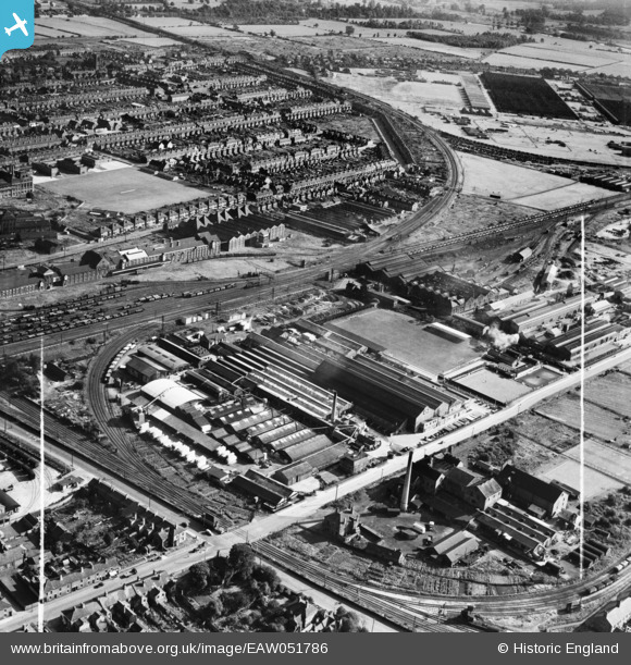
EAW051786 ENGLAND (1953). The Sharp Brothers and Knight Ltd Joinery Works and environs, Shobnall, 1953. This image was marked by Aerofilms Ltd for photo editing.
© Copyright OpenStreetMap contributors and licensed by the OpenStreetMap Foundation. 2025. Cartography is licensed as CC BY-SA.
Nearby Images (48)
Details
| Title | [EAW051786] The Sharp Brothers and Knight Ltd Joinery Works and environs, Shobnall, 1953. This image was marked by Aerofilms Ltd for photo editing. |
| Reference | EAW051786 |
| Date | 1-September-1953 |
| Link | |
| Place name | SHOBNALL |
| Parish | SHOBNALL |
| District | |
| Country | ENGLAND |
| Easting / Northing | 423777, 322759 |
| Longitude / Latitude | -1.6472836137918, 52.801531903584 |
| National Grid Reference | SK238228 |
Pins

Matt Aldred edob.mattaldred.com |
Saturday 19th of March 2022 08:08:28 PM |


![[EAW051786] The Sharp Brothers and Knight Ltd Joinery Works and environs, Shobnall, 1953. This image was marked by Aerofilms Ltd for photo editing.](http://britainfromabove.org.uk/sites/all/libraries/aerofilms-images/public/100x100/EAW/051/EAW051786.jpg)
![[EAW052803] The Sharp Brothers and Knight Ltd Joinery Works and environs, Shobnall, 1953. This image was marked by Aerofilms Ltd for photo editing.](http://britainfromabove.org.uk/sites/all/libraries/aerofilms-images/public/100x100/EAW/052/EAW052803.jpg)
![[EAW052802] The Sharp Brothers and Knight Ltd Joinery Works and environs, Shobnall, 1953. This image was marked by Aerofilms Ltd for photo editing.](http://britainfromabove.org.uk/sites/all/libraries/aerofilms-images/public/100x100/EAW/052/EAW052802.jpg)
![[EPW047939] The Cyclops Engineering Works and the Sharp Brothers and Knight Ltd Saw Mill, Shobnall, 1935](http://britainfromabove.org.uk/sites/all/libraries/aerofilms-images/public/100x100/EPW/047/EPW047939.jpg)
![[EAW052805] The Sharp Brothers and Knight Ltd Joinery Works and environs, Shobnall, 1953. This image was marked by Aerofilms Ltd for photo editing.](http://britainfromabove.org.uk/sites/all/libraries/aerofilms-images/public/100x100/EAW/052/EAW052805.jpg)
![[EAW052800] The Sharp Brothers and Knight Ltd Joinery Works and environs, Shobnall, 1953. This image was marked by Aerofilms Ltd for photo editing.](http://britainfromabove.org.uk/sites/all/libraries/aerofilms-images/public/100x100/EAW/052/EAW052800.jpg)
![[EAW052804] The Sharp Brothers and Knight Ltd Joinery Works and environs, Shobnall, 1953. This image was marked by Aerofilms Ltd for photo editing.](http://britainfromabove.org.uk/sites/all/libraries/aerofilms-images/public/100x100/EAW/052/EAW052804.jpg)
![[EAW052801] The Sharp Brothers and Knight Ltd Joinery Works and environs, Shobnall, 1953. This image was marked by Aerofilms Ltd for photo editing.](http://britainfromabove.org.uk/sites/all/libraries/aerofilms-images/public/100x100/EAW/052/EAW052801.jpg)
![[EAW052799] The Sharp Brothers and Knight Ltd Joinery Works and environs, Shobnall, 1953. This image was marked by Aerofilms Ltd for photo editing.](http://britainfromabove.org.uk/sites/all/libraries/aerofilms-images/public/100x100/EAW/052/EAW052799.jpg)
![[EAW052798] The Sharp Brothers and Knight Ltd Joinery Works and environs, Shobnall, 1953. This image was marked by Aerofilms Ltd for photo editing.](http://britainfromabove.org.uk/sites/all/libraries/aerofilms-images/public/100x100/EAW/052/EAW052798.jpg)
![[EPW047941] The Cyclops Engineering Works and environs, Shobnall, 1935](http://britainfromabove.org.uk/sites/all/libraries/aerofilms-images/public/100x100/EPW/047/EPW047941.jpg)
![[EPW047936] The Cyclops Engineering Works and the Sharp Brothers and Knight Ltd Saw Mill, Shobnall, 1935](http://britainfromabove.org.uk/sites/all/libraries/aerofilms-images/public/100x100/EPW/047/EPW047936.jpg)
![[EPW047937] The Cyclops Engineering Works and the Sharp Brothers and Knight Ltd Saw Mill, Shobnall, 1935](http://britainfromabove.org.uk/sites/all/libraries/aerofilms-images/public/100x100/EPW/047/EPW047937.jpg)
![[EAW028599] The Sharp Brothers and Knight Ltd Joinery Works and the Ind Coope and Allsopp Ltd Bottling Store, Shobnall, 1950. This image was marked by Aerofilms Ltd for photo editing.](http://britainfromabove.org.uk/sites/all/libraries/aerofilms-images/public/100x100/EAW/028/EAW028599.jpg)
![[EPW047938] The Cyclops Engineering Works and the Sharp Brothers and Knight Ltd Saw Mill, Shobnall, 1935](http://britainfromabove.org.uk/sites/all/libraries/aerofilms-images/public/100x100/EPW/047/EPW047938.jpg)
![[EPW047935] The Cyclops Engineering Works and environs, Shobnall, 1935](http://britainfromabove.org.uk/sites/all/libraries/aerofilms-images/public/100x100/EPW/047/EPW047935.jpg)
![[EPW047940] The Cyclops Engineering Works and environs, Shobnall, 1935](http://britainfromabove.org.uk/sites/all/libraries/aerofilms-images/public/100x100/EPW/047/EPW047940.jpg)
![[EAW000373] F.H. Lloyd & Co Foundry and environs, Shobnall, 1946. This image has been produced from a damaged negative.](http://britainfromabove.org.uk/sites/all/libraries/aerofilms-images/public/100x100/EAW/000/EAW000373.jpg)
![[EAW051789] The Sharp Brothers and Knight Ltd Joinery Works and environs, Shobnall, 1953. This image was marked by Aerofilms Ltd for photo editing.](http://britainfromabove.org.uk/sites/all/libraries/aerofilms-images/public/100x100/EAW/051/EAW051789.jpg)
![[EPW047950] The Cyclops Engineering Works and the Sharp Brothers and Knight Ltd Saw Milll, Shobnall, 1935](http://britainfromabove.org.uk/sites/all/libraries/aerofilms-images/public/100x100/EPW/047/EPW047950.jpg)
![[EAW028595] The Sharp Brothers and Knight Ltd Joinery Works, Shobnall, 1950. This image was marked by Aerofilms Ltd for photo editing.](http://britainfromabove.org.uk/sites/all/libraries/aerofilms-images/public/100x100/EAW/028/EAW028595.jpg)
![[EAW000372] F.H. Lloyd & Co Foundry and environs, Shobnall, 1946](http://britainfromabove.org.uk/sites/all/libraries/aerofilms-images/public/100x100/EAW/000/EAW000372.jpg)
![[EPW061071] Sharp Brothers & Knight Saw Mill and the Baguley Engine Works, Shobnall, 1939](http://britainfromabove.org.uk/sites/all/libraries/aerofilms-images/public/100x100/EPW/061/EPW061071.jpg)
![[EPW047949] The Cyclops Engineering Works and the Sharp Brothers and Knight Ltd Saw Milll, Shobnall, 1935](http://britainfromabove.org.uk/sites/all/libraries/aerofilms-images/public/100x100/EPW/047/EPW047949.jpg)
![[EAW028593] The Sharp Brothers and Knight Ltd Joinery Works, Shobnall, 1950. This image was marked by Aerofilms Ltd for photo editing.](http://britainfromabove.org.uk/sites/all/libraries/aerofilms-images/public/100x100/EAW/028/EAW028593.jpg)
![[EPW042721] The Sharp Brothers and Knight Ltd Saw Mill, the English Grains Co Ltd Cattle Food Works and the Cyclops Engineering Works, Shobnall, 1933](http://britainfromabove.org.uk/sites/all/libraries/aerofilms-images/public/100x100/EPW/042/EPW042721.jpg)
![[EAW051785] The Sharp Brothers and Knight Ltd Joinery Works and environs, Shobnall, 1953. This image was marked by Aerofilms Ltd for photo editing.](http://britainfromabove.org.uk/sites/all/libraries/aerofilms-images/public/100x100/EAW/051/EAW051785.jpg)
![[EPW042723] The Sharp Brothers and Knight Ltd Saw Mill, the English Grains Co Ltd Cattle Food Works and the Cyclops Engineering Works, Shobnall, 1933](http://britainfromabove.org.uk/sites/all/libraries/aerofilms-images/public/100x100/EPW/042/EPW042723.jpg)
![[EPW061070] Sharp Brothers & Knight Saw Mill and the Baguley Engine Works, Shobnall, 1939](http://britainfromabove.org.uk/sites/all/libraries/aerofilms-images/public/100x100/EPW/061/EPW061070.jpg)
![[EPW042722] The Sharp Brothers and Knight Ltd Saw Mill, the English Grains Co Ltd Cattle Food Works and the Cyclops Engineering Works, Shobnall, 1933. This image has been affected by flare.](http://britainfromabove.org.uk/sites/all/libraries/aerofilms-images/public/100x100/EPW/042/EPW042722.jpg)
![[EPW061073] Sharp Brothers & Knight Saw Mill and the Baguley Engine Works, Shobnall, 1939](http://britainfromabove.org.uk/sites/all/libraries/aerofilms-images/public/100x100/EPW/061/EPW061073.jpg)
![[EAW000377] F.H. Lloyd & Co Foundry, Shobnall, 1946. This image has been produced from a damaged negative.](http://britainfromabove.org.uk/sites/all/libraries/aerofilms-images/public/100x100/EAW/000/EAW000377.jpg)
![[EPW047945] The Sharp Brothers and Knight Ltd Saw Milll and environs, Shobnall, 1935](http://britainfromabove.org.uk/sites/all/libraries/aerofilms-images/public/100x100/EPW/047/EPW047945.jpg)
![[EPW020794A] Sharp Brothers and Knight Ltd Saw Mill, Burton upon Trent, 1928](http://britainfromabove.org.uk/sites/all/libraries/aerofilms-images/public/100x100/EPW/020/EPW020794A.jpg)
![[EPW020794] Sharp Brothers and Knight Ltd Saw Mill, Burton upon Trent, 1928](http://britainfromabove.org.uk/sites/all/libraries/aerofilms-images/public/100x100/EPW/020/EPW020794.jpg)
![[EPW061075] Sharp Brothers & Knight Saw Mill, the Baguley Engine Works and environs, Shobnall, 1939](http://britainfromabove.org.uk/sites/all/libraries/aerofilms-images/public/100x100/EPW/061/EPW061075.jpg)
![[EAW000376] F.H. Lloyd & Co Foundry, Shobnall, 1946](http://britainfromabove.org.uk/sites/all/libraries/aerofilms-images/public/100x100/EAW/000/EAW000376.jpg)
![[EPW047944] The Cyclops Engineering Works, the Sharp Brothers and Knight Ltd Saw Milll and environs, Shobnall, 1935](http://britainfromabove.org.uk/sites/all/libraries/aerofilms-images/public/100x100/EPW/047/EPW047944.jpg)
![[EPW061072] Sharp Brothers & Knight Saw Mill and the Baguley Engine Works, Shobnall, 1939](http://britainfromabove.org.uk/sites/all/libraries/aerofilms-images/public/100x100/EPW/061/EPW061072.jpg)
![[EAW000375] F.H. Lloyd & Co Foundry, Shobnall, 1946](http://britainfromabove.org.uk/sites/all/libraries/aerofilms-images/public/100x100/EAW/000/EAW000375.jpg)
![[EPW020797] Sharp Brothers and Knight Ltd Saw Mill, Burton upon Trent, 1928](http://britainfromabove.org.uk/sites/all/libraries/aerofilms-images/public/100x100/EPW/020/EPW020797.jpg)
![[EPW020796A] Sharp Brothers and Knight Ltd Saw Mill, Burton upon Trent, 1928](http://britainfromabove.org.uk/sites/all/libraries/aerofilms-images/public/100x100/EPW/020/EPW020796A.jpg)
![[EPW042720] The Sharp Brothers and Knight Ltd Saw Mill, the English Grains Co Ltd Cattle Food Works and Shobnall Road, Shobnall, 1933](http://britainfromabove.org.uk/sites/all/libraries/aerofilms-images/public/100x100/EPW/042/EPW042720.jpg)
![[EPW061076] Sharp Brothers & Knight Saw Mill, the Baguley Engine Works and environs, Shobnall, 1939](http://britainfromabove.org.uk/sites/all/libraries/aerofilms-images/public/100x100/EPW/061/EPW061076.jpg)
![[EAW051791] The Sharp Brothers and Knight Ltd Joinery Works and environs, Shobnall, 1953. This image was marked by Aerofilms Ltd for photo editing.](http://britainfromabove.org.uk/sites/all/libraries/aerofilms-images/public/100x100/EAW/051/EAW051791.jpg)
![[EAW000374] F.H. Lloyd & Co Foundry, Shobnall, 1946](http://britainfromabove.org.uk/sites/all/libraries/aerofilms-images/public/100x100/EAW/000/EAW000374.jpg)
![[EAW000371] F.H. Lloyd & Co Foundry, Shobnall, 1946](http://britainfromabove.org.uk/sites/all/libraries/aerofilms-images/public/100x100/EAW/000/EAW000371.jpg)
![[EAW000370] F.H. Lloyd & Co Foundry, Shobnall, 1946](http://britainfromabove.org.uk/sites/all/libraries/aerofilms-images/public/100x100/EAW/000/EAW000370.jpg)