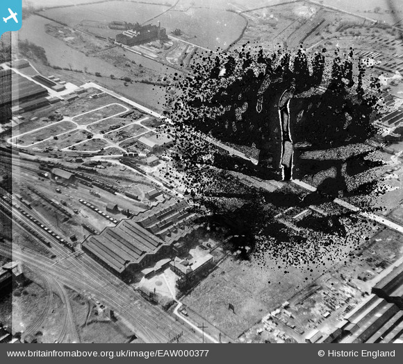
EAW000377 ENGLAND (1946). F.H. Lloyd & Co Foundry, Shobnall, 1946. This image has been produced from a damaged negative.
© Copyright OpenStreetMap contributors and licensed by the OpenStreetMap Foundation. 2026. Cartography is licensed as CC BY-SA.
Nearby Images (34)
Details
| Title | [EAW000377] F.H. Lloyd & Co Foundry, Shobnall, 1946. This image has been produced from a damaged negative. |
| Reference | EAW000377 |
| Date | 16-April-1946 |
| Link | |
| Place name | SHOBNALL |
| Parish | SHOBNALL |
| District | |
| Country | ENGLAND |
| Easting / Northing | 423601, 322676 |
| Longitude / Latitude | -1.6499003990751, 52.800793434773 |
| National Grid Reference | SK236227 |
Pins
Be the first to add a comment to this image!


![[EAW000377] F.H. Lloyd & Co Foundry, Shobnall, 1946. This image has been produced from a damaged negative.](http://britainfromabove.org.uk/sites/all/libraries/aerofilms-images/public/100x100/EAW/000/EAW000377.jpg)
![[EAW000375] F.H. Lloyd & Co Foundry, Shobnall, 1946](http://britainfromabove.org.uk/sites/all/libraries/aerofilms-images/public/100x100/EAW/000/EAW000375.jpg)
![[EAW000372] F.H. Lloyd & Co Foundry and environs, Shobnall, 1946](http://britainfromabove.org.uk/sites/all/libraries/aerofilms-images/public/100x100/EAW/000/EAW000372.jpg)
![[EAW000376] F.H. Lloyd & Co Foundry, Shobnall, 1946](http://britainfromabove.org.uk/sites/all/libraries/aerofilms-images/public/100x100/EAW/000/EAW000376.jpg)
![[EAW000373] F.H. Lloyd & Co Foundry and environs, Shobnall, 1946. This image has been produced from a damaged negative.](http://britainfromabove.org.uk/sites/all/libraries/aerofilms-images/public/100x100/EAW/000/EAW000373.jpg)
![[EAW000374] F.H. Lloyd & Co Foundry, Shobnall, 1946](http://britainfromabove.org.uk/sites/all/libraries/aerofilms-images/public/100x100/EAW/000/EAW000374.jpg)
![[EAW000371] F.H. Lloyd & Co Foundry, Shobnall, 1946](http://britainfromabove.org.uk/sites/all/libraries/aerofilms-images/public/100x100/EAW/000/EAW000371.jpg)
![[EAW000369] F.H. Lloyd & Co Foundry and environs, Shobnall, 1946](http://britainfromabove.org.uk/sites/all/libraries/aerofilms-images/public/100x100/EAW/000/EAW000369.jpg)
![[EAW000370] F.H. Lloyd & Co Foundry, Shobnall, 1946](http://britainfromabove.org.uk/sites/all/libraries/aerofilms-images/public/100x100/EAW/000/EAW000370.jpg)
![[EAW052804] The Sharp Brothers and Knight Ltd Joinery Works and environs, Shobnall, 1953. This image was marked by Aerofilms Ltd for photo editing.](http://britainfromabove.org.uk/sites/all/libraries/aerofilms-images/public/100x100/EAW/052/EAW052804.jpg)
![[EAW052801] The Sharp Brothers and Knight Ltd Joinery Works and environs, Shobnall, 1953. This image was marked by Aerofilms Ltd for photo editing.](http://britainfromabove.org.uk/sites/all/libraries/aerofilms-images/public/100x100/EAW/052/EAW052801.jpg)
![[EAW051786] The Sharp Brothers and Knight Ltd Joinery Works and environs, Shobnall, 1953. This image was marked by Aerofilms Ltd for photo editing.](http://britainfromabove.org.uk/sites/all/libraries/aerofilms-images/public/100x100/EAW/051/EAW051786.jpg)
![[EAW052802] The Sharp Brothers and Knight Ltd Joinery Works and environs, Shobnall, 1953. This image was marked by Aerofilms Ltd for photo editing.](http://britainfromabove.org.uk/sites/all/libraries/aerofilms-images/public/100x100/EAW/052/EAW052802.jpg)
![[EAW052805] The Sharp Brothers and Knight Ltd Joinery Works and environs, Shobnall, 1953. This image was marked by Aerofilms Ltd for photo editing.](http://britainfromabove.org.uk/sites/all/libraries/aerofilms-images/public/100x100/EAW/052/EAW052805.jpg)
![[EAW052803] The Sharp Brothers and Knight Ltd Joinery Works and environs, Shobnall, 1953. This image was marked by Aerofilms Ltd for photo editing.](http://britainfromabove.org.uk/sites/all/libraries/aerofilms-images/public/100x100/EAW/052/EAW052803.jpg)
![[EPW047941] The Cyclops Engineering Works and environs, Shobnall, 1935](http://britainfromabove.org.uk/sites/all/libraries/aerofilms-images/public/100x100/EPW/047/EPW047941.jpg)
![[EPW047939] The Cyclops Engineering Works and the Sharp Brothers and Knight Ltd Saw Mill, Shobnall, 1935](http://britainfromabove.org.uk/sites/all/libraries/aerofilms-images/public/100x100/EPW/047/EPW047939.jpg)
![[EAW052798] The Sharp Brothers and Knight Ltd Joinery Works and environs, Shobnall, 1953. This image was marked by Aerofilms Ltd for photo editing.](http://britainfromabove.org.uk/sites/all/libraries/aerofilms-images/public/100x100/EAW/052/EAW052798.jpg)
![[EPW047937] The Cyclops Engineering Works and the Sharp Brothers and Knight Ltd Saw Mill, Shobnall, 1935](http://britainfromabove.org.uk/sites/all/libraries/aerofilms-images/public/100x100/EPW/047/EPW047937.jpg)
![[EPW047936] The Cyclops Engineering Works and the Sharp Brothers and Knight Ltd Saw Mill, Shobnall, 1935](http://britainfromabove.org.uk/sites/all/libraries/aerofilms-images/public/100x100/EPW/047/EPW047936.jpg)
![[EAW052799] The Sharp Brothers and Knight Ltd Joinery Works and environs, Shobnall, 1953. This image was marked by Aerofilms Ltd for photo editing.](http://britainfromabove.org.uk/sites/all/libraries/aerofilms-images/public/100x100/EAW/052/EAW052799.jpg)
![[EPW047938] The Cyclops Engineering Works and the Sharp Brothers and Knight Ltd Saw Mill, Shobnall, 1935](http://britainfromabove.org.uk/sites/all/libraries/aerofilms-images/public/100x100/EPW/047/EPW047938.jpg)
![[EAW052800] The Sharp Brothers and Knight Ltd Joinery Works and environs, Shobnall, 1953. This image was marked by Aerofilms Ltd for photo editing.](http://britainfromabove.org.uk/sites/all/libraries/aerofilms-images/public/100x100/EAW/052/EAW052800.jpg)
![[EPW047940] The Cyclops Engineering Works and environs, Shobnall, 1935](http://britainfromabove.org.uk/sites/all/libraries/aerofilms-images/public/100x100/EPW/047/EPW047940.jpg)
![[EPW047935] The Cyclops Engineering Works and environs, Shobnall, 1935](http://britainfromabove.org.uk/sites/all/libraries/aerofilms-images/public/100x100/EPW/047/EPW047935.jpg)
![[EAW028599] The Sharp Brothers and Knight Ltd Joinery Works and the Ind Coope and Allsopp Ltd Bottling Store, Shobnall, 1950. This image was marked by Aerofilms Ltd for photo editing.](http://britainfromabove.org.uk/sites/all/libraries/aerofilms-images/public/100x100/EAW/028/EAW028599.jpg)
![[EAW051783] The Sharp Brothers and Knight Ltd Joinery Works, the Clarence Street Brewery and environs, Shobnall, 1953. This image was marked by Aerofilms Ltd for photo editing.](http://britainfromabove.org.uk/sites/all/libraries/aerofilms-images/public/100x100/EAW/051/EAW051783.jpg)
![[EAW028598] The Sharp Brothers and Knight Ltd Joinery Works, Shobnall, 1950. This image was marked by Aerofilms Ltd for photo editing.](http://britainfromabove.org.uk/sites/all/libraries/aerofilms-images/public/100x100/EAW/028/EAW028598.jpg)
![[EAW051789] The Sharp Brothers and Knight Ltd Joinery Works and environs, Shobnall, 1953. This image was marked by Aerofilms Ltd for photo editing.](http://britainfromabove.org.uk/sites/all/libraries/aerofilms-images/public/100x100/EAW/051/EAW051789.jpg)
![[EPW047950] The Cyclops Engineering Works and the Sharp Brothers and Knight Ltd Saw Milll, Shobnall, 1935](http://britainfromabove.org.uk/sites/all/libraries/aerofilms-images/public/100x100/EPW/047/EPW047950.jpg)
![[EAW028595] The Sharp Brothers and Knight Ltd Joinery Works, Shobnall, 1950. This image was marked by Aerofilms Ltd for photo editing.](http://britainfromabove.org.uk/sites/all/libraries/aerofilms-images/public/100x100/EAW/028/EAW028595.jpg)
![[EAW028596] The Sharp Brothers and Knight Ltd Joinery Works, Shobnall, 1950. This image was marked by Aerofilms Ltd for photo editing.](http://britainfromabove.org.uk/sites/all/libraries/aerofilms-images/public/100x100/EAW/028/EAW028596.jpg)
![[EAW028597] The Sharp Brothers and Knight Ltd Joinery Works and the Ind Coope and Allsopp Ltd Bottling Store, Shobnall, 1950. This image was marked by Aerofilms Ltd for photo editing.](http://britainfromabove.org.uk/sites/all/libraries/aerofilms-images/public/100x100/EAW/028/EAW028597.jpg)
![[EPW042719] The Sharp Brothers and Knight Ltd Saw Mill, Shobnall, 1933. This image has been produced from a damaged negative.](http://britainfromabove.org.uk/sites/all/libraries/aerofilms-images/public/100x100/EPW/042/EPW042719.jpg)