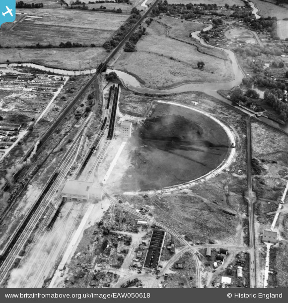
EAW050618 ENGLAND (1953). The Rye House Power Station coal yard, Rye Park, 1953
© Copyright OpenStreetMap contributors and licensed by the OpenStreetMap Foundation. 2025. Cartography is licensed as CC BY-SA.
Nearby Images (21)
Details
| Title | [EAW050618] The Rye House Power Station coal yard, Rye Park, 1953 |
| Reference | EAW050618 |
| Date | 15-July-1953 |
| Link | |
| Place name | RYE PARK |
| Parish | |
| District | |
| Country | ENGLAND |
| Easting / Northing | 538815, 209134 |
| Longitude / Latitude | 0.011746220205895, 51.763204473088 |
| National Grid Reference | TL388091 |
Pins
Be the first to add a comment to this image!


![[EAW050618] The Rye House Power Station coal yard, Rye Park, 1953](http://britainfromabove.org.uk/sites/all/libraries/aerofilms-images/public/100x100/EAW/050/EAW050618.jpg)
![[EAW050620] The Rye House Power Station coal yard, Rye Park, 1953](http://britainfromabove.org.uk/sites/all/libraries/aerofilms-images/public/100x100/EAW/050/EAW050620.jpg)
![[EAW050619] Rye House Power Station, Rye Park, 1953](http://britainfromabove.org.uk/sites/all/libraries/aerofilms-images/public/100x100/EAW/050/EAW050619.jpg)
![[EAW022406] Rye House Power Station under construction and environs, Rye Park, 1949. This image was marked by Aerofilms Ltd for photo editing.](http://britainfromabove.org.uk/sites/all/libraries/aerofilms-images/public/100x100/EAW/022/EAW022406.jpg)
![[EAW026290] Rye House Power Station under construction and the surrounding area, Rye Park, 1949. This image has been produced from a print marked by Aerofilms Ltd for photo editing.](http://britainfromabove.org.uk/sites/all/libraries/aerofilms-images/public/100x100/EAW/026/EAW026290.jpg)
![[EAW050631] Rye House Power Station and environs, Rye Park, from the north, 1953](http://britainfromabove.org.uk/sites/all/libraries/aerofilms-images/public/100x100/EAW/050/EAW050631.jpg)
![[EAW040603] Rye House Power Station under construction, Rye Park, 1951](http://britainfromabove.org.uk/sites/all/libraries/aerofilms-images/public/100x100/EAW/040/EAW040603.jpg)
![[EAW022409] Rye House Power Station under construction and environs, Rye Park, 1949. This image was marked by Aerofilms Ltd for photo editing.](http://britainfromabove.org.uk/sites/all/libraries/aerofilms-images/public/100x100/EAW/022/EAW022409.jpg)
![[EAW026293] The Rye House Power Station Cooling Tower water channel under construction, Rye Park, 1949. This image has been produced from a print.](http://britainfromabove.org.uk/sites/all/libraries/aerofilms-images/public/100x100/EAW/026/EAW026293.jpg)
![[EAW026287] Rye House Power Station and Cooling Tower under construction, Ratty's Lane and environs, Rye Park, from the north-east, 1949. This image has been produced from a print marked by Aerofilms Ltd for photo editing.](http://britainfromabove.org.uk/sites/all/libraries/aerofilms-images/public/100x100/EAW/026/EAW026287.jpg)
![[EAW050629] Rye House Power Station, Rye Park, 1953](http://britainfromabove.org.uk/sites/all/libraries/aerofilms-images/public/100x100/EAW/050/EAW050629.jpg)
![[EAW022408] Rye House Power Station under construction and environs, Rye Park, 1949](http://britainfromabove.org.uk/sites/all/libraries/aerofilms-images/public/100x100/EAW/022/EAW022408.jpg)
![[EAW026295] The Rye House Power Station Cooling Tower water channel under construction, Rye Park, 1949. This image has been produced from a print.](http://britainfromabove.org.uk/sites/all/libraries/aerofilms-images/public/100x100/EAW/026/EAW026295.jpg)
![[EAW026294] The Rye House Power Station Cooling Tower water channel under construction, Rye Park, 1949. This image has been produced from a print.](http://britainfromabove.org.uk/sites/all/libraries/aerofilms-images/public/100x100/EAW/026/EAW026294.jpg)
![[EAW022413] Rye House Power Station under construction, Rye Park, 1949](http://britainfromabove.org.uk/sites/all/libraries/aerofilms-images/public/100x100/EAW/022/EAW022413.jpg)
![[EAW027788] Rye House Power Station under construction, Rye Park, 1949. This image was marked by Aerofilms Ltd for photo editing.](http://britainfromabove.org.uk/sites/all/libraries/aerofilms-images/public/100x100/EAW/027/EAW027788.jpg)
![[EAW040624] Rye House Power Station under construction, Rye Park, 1951](http://britainfromabove.org.uk/sites/all/libraries/aerofilms-images/public/100x100/EAW/040/EAW040624.jpg)
![[EAW040623] Rye House Power Station under construction, Rye Park, 1951](http://britainfromabove.org.uk/sites/all/libraries/aerofilms-images/public/100x100/EAW/040/EAW040623.jpg)
![[EAW050625] Rye House Power Station, Rye Park, 1953](http://britainfromabove.org.uk/sites/all/libraries/aerofilms-images/public/100x100/EAW/050/EAW050625.jpg)
![[EAW034499] Rye House Power Station under construction, Rye Park, 1951. This image has been produced from a print marked by Aerofilms Ltd for photo editing.](http://britainfromabove.org.uk/sites/all/libraries/aerofilms-images/public/100x100/EAW/034/EAW034499.jpg)
![[EAW032354] Rye House Power Station under construction, Rye Park, 1950](http://britainfromabove.org.uk/sites/all/libraries/aerofilms-images/public/100x100/EAW/032/EAW032354.jpg)