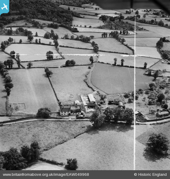
EAW049968 ENGLAND (1953). Fly Boat Farm, Pitminster, 1953. This image was marked by Aerofilms Ltd for photo editing.
© Copyright OpenStreetMap contributors and licensed by the OpenStreetMap Foundation. 2025. Cartography is licensed as CC BY-SA.
Nearby Images (6)
Details
| Title | [EAW049968] Fly Boat Farm, Pitminster, 1953. This image was marked by Aerofilms Ltd for photo editing. |
| Reference | EAW049968 |
| Date | 18-June-1953 |
| Link | |
| Place name | PITMINSTER |
| Parish | PITMINSTER |
| District | |
| Country | ENGLAND |
| Easting / Northing | 322388, 119168 |
| Longitude / Latitude | -3.1053791795712, 50.96615262594 |
| National Grid Reference | ST224192 |
Pins
Be the first to add a comment to this image!


![[EAW049968] Fly Boat Farm, Pitminster, 1953. This image was marked by Aerofilms Ltd for photo editing.](http://britainfromabove.org.uk/sites/all/libraries/aerofilms-images/public/100x100/EAW/049/EAW049968.jpg)
![[EAW049973] Fly Boat Farm and the village, Pitminster, 1953. This image was marked by Aerofilms Ltd for photo editing.](http://britainfromabove.org.uk/sites/all/libraries/aerofilms-images/public/100x100/EAW/049/EAW049973.jpg)
![[EAW049971] Fly Boat Farm, Pitminster, 1953. This image was marked by Aerofilms Ltd for photo editing.](http://britainfromabove.org.uk/sites/all/libraries/aerofilms-images/public/100x100/EAW/049/EAW049971.jpg)
![[EAW049969] Fly Boat Farm, Pitminster, 1953. This image was marked by Aerofilms Ltd for photo editing.](http://britainfromabove.org.uk/sites/all/libraries/aerofilms-images/public/100x100/EAW/049/EAW049969.jpg)
![[EAW049972] Fly Boat Farm, Pitminster, 1953](http://britainfromabove.org.uk/sites/all/libraries/aerofilms-images/public/100x100/EAW/049/EAW049972.jpg)
![[EAW049970] Fly Boat Farm and the surrounding countryside, Pitminster, from the north, 1953. This image was marked by Aerofilms Ltd for photo editing.](http://britainfromabove.org.uk/sites/all/libraries/aerofilms-images/public/100x100/EAW/049/EAW049970.jpg)