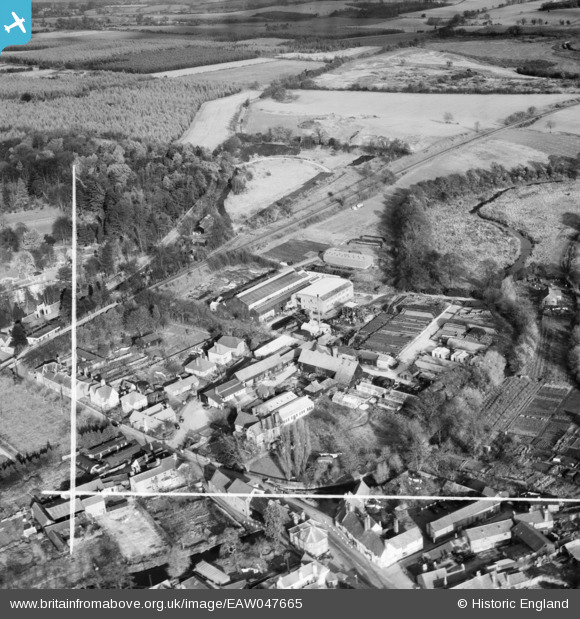
EAW047665 ENGLAND (1952). Wheathampstead Place, the Murphy Chemical Co Works and environs, Wheathampstead, 1952. This image was marked by Aerofilms Ltd for photo editing.
© Copyright OpenStreetMap contributors and licensed by the OpenStreetMap Foundation. 2026. Cartography is licensed as CC BY-SA.
Nearby Images (16)
Details
| Title | [EAW047665] Wheathampstead Place, the Murphy Chemical Co Works and environs, Wheathampstead, 1952. This image was marked by Aerofilms Ltd for photo editing. |
| Reference | EAW047665 |
| Date | 3-November-1952 |
| Link | |
| Place name | WHEATHAMPSTEAD |
| Parish | WHEATHAMPSTEAD |
| District | |
| Country | ENGLAND |
| Easting / Northing | 517900, 214285 |
| Longitude / Latitude | -0.28945056027347, 51.814297460301 |
| National Grid Reference | TL179143 |
Pins
Be the first to add a comment to this image!


![[EAW047665] Wheathampstead Place, the Murphy Chemical Co Works and environs, Wheathampstead, 1952. This image was marked by Aerofilms Ltd for photo editing.](http://britainfromabove.org.uk/sites/all/libraries/aerofilms-images/public/100x100/EAW/047/EAW047665.jpg)
![[EAW047668] Wheathampstead House, the Murphy Chemical Co Works and environs, Wheathampstead, 1952. This image was marked by Aerofilms Ltd for photo editing.](http://britainfromabove.org.uk/sites/all/libraries/aerofilms-images/public/100x100/EAW/047/EAW047668.jpg)
![[EAW047664] Wheathampstead Place, the Murphy Chemical Co Works and environs, Wheathampstead, 1952](http://britainfromabove.org.uk/sites/all/libraries/aerofilms-images/public/100x100/EAW/047/EAW047664.jpg)
![[EAW047662] The Murphy Chemical Co Works and environs, Wheathampstead, 1952. This image was marked by Aerofilms Ltd for photo editing.](http://britainfromabove.org.uk/sites/all/libraries/aerofilms-images/public/100x100/EAW/047/EAW047662.jpg)
![[EAW047658] The Murphy Chemical Co Works and environs, Wheathampstead, 1952. This image was marked by Aerofilms Ltd for photo editing.](http://britainfromabove.org.uk/sites/all/libraries/aerofilms-images/public/100x100/EAW/047/EAW047658.jpg)
![[EAW047663] Wheathampstead House, the Murphy Chemical Co Works and environs, Wheathampstead, 1952. This image was marked by Aerofilms Ltd for photo editing.](http://britainfromabove.org.uk/sites/all/libraries/aerofilms-images/public/100x100/EAW/047/EAW047663.jpg)
![[EAW047669] Wheathampstead House, the Murphy Chemical Co Works and environs, Wheathampstead, 1952. This image was marked by Aerofilms Ltd for photo editing.](http://britainfromabove.org.uk/sites/all/libraries/aerofilms-images/public/100x100/EAW/047/EAW047669.jpg)
![[EAW047659] The Murphy Chemical Co Works and environs, Wheathampstead, 1952. This image was marked by Aerofilms Ltd for photo editing.](http://britainfromabove.org.uk/sites/all/libraries/aerofilms-images/public/100x100/EAW/047/EAW047659.jpg)
![[EAW047666] The Murphy Chemical Co Works and environs, Wheathampstead, 1952](http://britainfromabove.org.uk/sites/all/libraries/aerofilms-images/public/100x100/EAW/047/EAW047666.jpg)
![[EAW047660] The Murphy Chemical Co Works and environs, Wheathampstead, 1952. This image was marked by Aerofilms Ltd for photo editing.](http://britainfromabove.org.uk/sites/all/libraries/aerofilms-images/public/100x100/EAW/047/EAW047660.jpg)
![[EAW047667] Wheathampstead Place, Wheathampstead, 1952. This image was marked by Aerofilms Ltd for photo editing.](http://britainfromabove.org.uk/sites/all/libraries/aerofilms-images/public/100x100/EAW/047/EAW047667.jpg)
![[EAW047661] Wheathampstead House, the Murphy Chemical Co Works and environs, Wheathampstead, 1952. This image was marked by Aerofilms Ltd for photo editing.](http://britainfromabove.org.uk/sites/all/libraries/aerofilms-images/public/100x100/EAW/047/EAW047661.jpg)
![[EAW015567] The village, Wheathampstead, 1948](http://britainfromabove.org.uk/sites/all/libraries/aerofilms-images/public/100x100/EAW/015/EAW015567.jpg)
![[EAW015565] St Helen's Church and the village, Wheathampstead, 1948](http://britainfromabove.org.uk/sites/all/libraries/aerofilms-images/public/100x100/EAW/015/EAW015565.jpg)
![[EAW015564] St Helen's Church and the village, Wheathampstead, 1948](http://britainfromabove.org.uk/sites/all/libraries/aerofilms-images/public/100x100/EAW/015/EAW015564.jpg)
![[EAW015566] St Helen's Church and the village, Wheathampstead, 1948](http://britainfromabove.org.uk/sites/all/libraries/aerofilms-images/public/100x100/EAW/015/EAW015566.jpg)