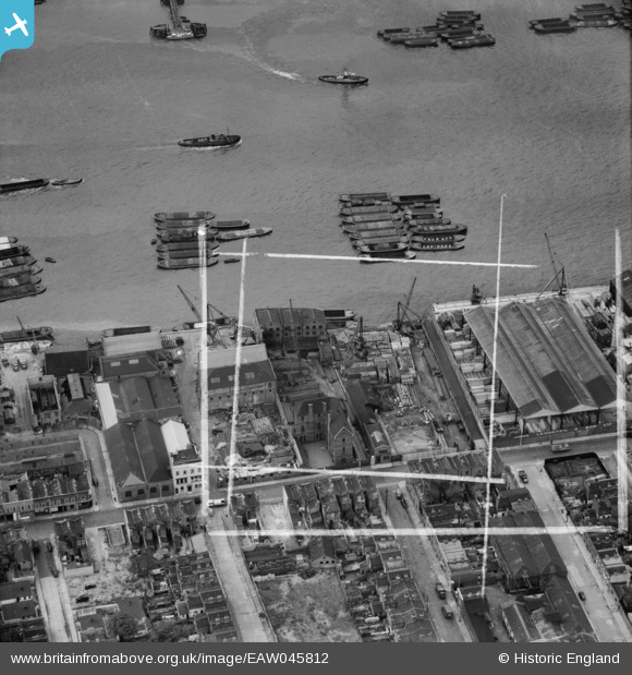
EAW045812 ENGLAND (1952). Wharfage on the River Thames behind West Ferry Road, Millwall, 1952. This image was marked by Aerofilms Ltd for photo editing.
© Copyright OpenStreetMap contributors and licensed by the OpenStreetMap Foundation. 2026. Cartography is licensed as CC BY-SA.
Nearby Images (17)
Details
| Title | [EAW045812] Wharfage on the River Thames behind West Ferry Road, Millwall, 1952. This image was marked by Aerofilms Ltd for photo editing. |
| Reference | EAW045812 |
| Date | 31-July-1952 |
| Link | |
| Place name | MILLWALL |
| Parish | |
| District | |
| Country | ENGLAND |
| Easting / Northing | 537030, 179740 |
| Longitude / Latitude | -0.025612009113079, 51.49948238018 |
| National Grid Reference | TQ370797 |
Pins

moses72 |
Saturday 19th of July 2014 01:04:13 PM | |

moses72 |
Saturday 19th of July 2014 01:03:39 PM | |

Pete James |
Friday 4th of July 2014 11:55:01 AM | |

Pete James |
Friday 4th of July 2014 09:09:07 AM | |

Pete James |
Friday 4th of July 2014 09:07:09 AM |


![[EAW045812] Wharfage on the River Thames behind West Ferry Road, Millwall, 1952. This image was marked by Aerofilms Ltd for photo editing.](http://britainfromabove.org.uk/sites/all/libraries/aerofilms-images/public/100x100/EAW/045/EAW045812.jpg)
![[EAW045680] Express Wharf, Millwall, 1952. This image was marked by Aerofilms Ltd for photo editing.](http://britainfromabove.org.uk/sites/all/libraries/aerofilms-images/public/100x100/EAW/045/EAW045680.jpg)
![[EAW045676] Express Wharf, Millwall, 1952. This image was marked by Aerofilms Ltd for photo editing.](http://britainfromabove.org.uk/sites/all/libraries/aerofilms-images/public/100x100/EAW/045/EAW045676.jpg)
![[EAW045811] Wharfage on the River Thames behind West Ferry Road, Millwall, 1952. This image was marked by Aerofilms Ltd for photo editing.](http://britainfromabove.org.uk/sites/all/libraries/aerofilms-images/public/100x100/EAW/045/EAW045811.jpg)
![[EAW045807] Wharfage on the River Thames behind West Ferry Road, Millwall, 1952. This image was marked by Aerofilms Ltd for photo editing.](http://britainfromabove.org.uk/sites/all/libraries/aerofilms-images/public/100x100/EAW/045/EAW045807.jpg)
![[EAW045809] Byng Street, Strafford Street and wharfage on the River Thames behind West Ferry Road, Millwall, 1952. This image was marked by Aerofilms Ltd for photo editing.](http://britainfromabove.org.uk/sites/all/libraries/aerofilms-images/public/100x100/EAW/045/EAW045809.jpg)
![[EAW045677] Express Wharf, Millwall, 1952. This image was marked by Aerofilms Ltd for photo editing.](http://britainfromabove.org.uk/sites/all/libraries/aerofilms-images/public/100x100/EAW/045/EAW045677.jpg)
![[EAW045679] Express Wharf, Millwall, 1952. This image was marked by Aerofilms Ltd for photo editing.](http://britainfromabove.org.uk/sites/all/libraries/aerofilms-images/public/100x100/EAW/045/EAW045679.jpg)
![[EAW045810] West Ferry Road and environs, Millwall, 1952. This image was marked by Aerofilms Ltd for photo editing.](http://britainfromabove.org.uk/sites/all/libraries/aerofilms-images/public/100x100/EAW/045/EAW045810.jpg)
![[EAW045813] Wharfage on the River Thames behind West Ferry Road, Millwall, 1952. This image was marked by Aerofilms Ltd for photo editing.](http://britainfromabove.org.uk/sites/all/libraries/aerofilms-images/public/100x100/EAW/045/EAW045813.jpg)
![[EAW045808] Strafford Street and wharfage on the River Thames behind West Ferry Road, Millwall, 1952. This image was marked by Aerofilms Ltd for photo editing.](http://britainfromabove.org.uk/sites/all/libraries/aerofilms-images/public/100x100/EAW/045/EAW045808.jpg)
![[EAW045675] Express Wharf, Millwall, 1952. This image was marked by Aerofilms Ltd for photo editing.](http://britainfromabove.org.uk/sites/all/libraries/aerofilms-images/public/100x100/EAW/045/EAW045675.jpg)
![[EAW045673] Express Wharf, Millwall, 1952. This image was marked by Aerofilms Ltd for photo editing.](http://britainfromabove.org.uk/sites/all/libraries/aerofilms-images/public/100x100/EAW/045/EAW045673.jpg)
![[EAW045678] Express Wharf, Millwall, 1952. This image was marked by Aerofilms Ltd for photo editing.](http://britainfromabove.org.uk/sites/all/libraries/aerofilms-images/public/100x100/EAW/045/EAW045678.jpg)
![[EAW045674] Express Wharf, Millwall, 1952. This image was marked by Aerofilms Ltd for photo editing.](http://britainfromabove.org.uk/sites/all/libraries/aerofilms-images/public/100x100/EAW/045/EAW045674.jpg)
![[EAW016654] Millwall and the River Thames, Isle of Dogs, from the north, 1948](http://britainfromabove.org.uk/sites/all/libraries/aerofilms-images/public/100x100/EAW/016/EAW016654.jpg)
![[EPW060776] The River Thames and surrounding city from Rotherhithe towards the Royal Docks, Isle of Dogs, from the south-west, 1939](http://britainfromabove.org.uk/sites/all/libraries/aerofilms-images/public/100x100/EPW/060/EPW060776.jpg)