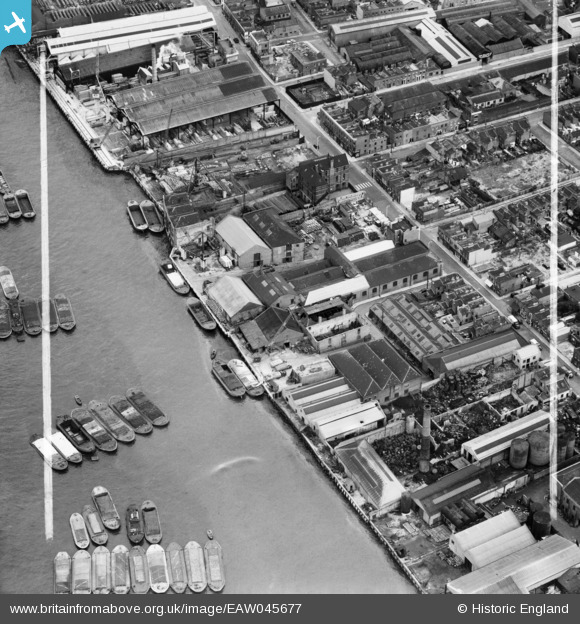
EAW045677 ENGLAND (1952). Express Wharf, Millwall, 1952. This image was marked by Aerofilms Ltd for photo editing.
© Copyright OpenStreetMap contributors and licensed by the OpenStreetMap Foundation. 2026. Cartography is licensed as CC BY-SA.
Nearby Images (17)
Details
| Title | [EAW045677] Express Wharf, Millwall, 1952. This image was marked by Aerofilms Ltd for photo editing. |
| Reference | EAW045677 |
| Date | 31-July-1952 |
| Link | |
| Place name | MILLWALL |
| Parish | |
| District | |
| Country | ENGLAND |
| Easting / Northing | 537047, 179657 |
| Longitude / Latitude | -0.025399468867623, 51.4987323235 |
| National Grid Reference | TQ370797 |
Pins

Pete James |
Sunday 10th of August 2014 12:45:07 AM | |

Con Maloney |
Saturday 19th of July 2014 11:34:33 PM | |
Hi Con Are there any photos of St Lukes before demolished?? Val |

Valerie Martin |
Saturday 28th of February 2015 08:49:53 AM |

Con Maloney |
Saturday 19th of July 2014 11:33:40 PM | |

Pete James |
Friday 4th of July 2014 12:35:30 AM |


![[EAW045677] Express Wharf, Millwall, 1952. This image was marked by Aerofilms Ltd for photo editing.](http://britainfromabove.org.uk/sites/all/libraries/aerofilms-images/public/100x100/EAW/045/EAW045677.jpg)
![[EAW045679] Express Wharf, Millwall, 1952. This image was marked by Aerofilms Ltd for photo editing.](http://britainfromabove.org.uk/sites/all/libraries/aerofilms-images/public/100x100/EAW/045/EAW045679.jpg)
![[EAW045673] Express Wharf, Millwall, 1952. This image was marked by Aerofilms Ltd for photo editing.](http://britainfromabove.org.uk/sites/all/libraries/aerofilms-images/public/100x100/EAW/045/EAW045673.jpg)
![[EAW045675] Express Wharf, Millwall, 1952. This image was marked by Aerofilms Ltd for photo editing.](http://britainfromabove.org.uk/sites/all/libraries/aerofilms-images/public/100x100/EAW/045/EAW045675.jpg)
![[EAW045678] Express Wharf, Millwall, 1952. This image was marked by Aerofilms Ltd for photo editing.](http://britainfromabove.org.uk/sites/all/libraries/aerofilms-images/public/100x100/EAW/045/EAW045678.jpg)
![[EAW045680] Express Wharf, Millwall, 1952. This image was marked by Aerofilms Ltd for photo editing.](http://britainfromabove.org.uk/sites/all/libraries/aerofilms-images/public/100x100/EAW/045/EAW045680.jpg)
![[EAW045674] Express Wharf, Millwall, 1952. This image was marked by Aerofilms Ltd for photo editing.](http://britainfromabove.org.uk/sites/all/libraries/aerofilms-images/public/100x100/EAW/045/EAW045674.jpg)
![[EAW045810] West Ferry Road and environs, Millwall, 1952. This image was marked by Aerofilms Ltd for photo editing.](http://britainfromabove.org.uk/sites/all/libraries/aerofilms-images/public/100x100/EAW/045/EAW045810.jpg)
![[EAW045812] Wharfage on the River Thames behind West Ferry Road, Millwall, 1952. This image was marked by Aerofilms Ltd for photo editing.](http://britainfromabove.org.uk/sites/all/libraries/aerofilms-images/public/100x100/EAW/045/EAW045812.jpg)
![[EAW045676] Express Wharf, Millwall, 1952. This image was marked by Aerofilms Ltd for photo editing.](http://britainfromabove.org.uk/sites/all/libraries/aerofilms-images/public/100x100/EAW/045/EAW045676.jpg)
![[EAW045807] Wharfage on the River Thames behind West Ferry Road, Millwall, 1952. This image was marked by Aerofilms Ltd for photo editing.](http://britainfromabove.org.uk/sites/all/libraries/aerofilms-images/public/100x100/EAW/045/EAW045807.jpg)
![[EAW045809] Byng Street, Strafford Street and wharfage on the River Thames behind West Ferry Road, Millwall, 1952. This image was marked by Aerofilms Ltd for photo editing.](http://britainfromabove.org.uk/sites/all/libraries/aerofilms-images/public/100x100/EAW/045/EAW045809.jpg)
![[EAW045811] Wharfage on the River Thames behind West Ferry Road, Millwall, 1952. This image was marked by Aerofilms Ltd for photo editing.](http://britainfromabove.org.uk/sites/all/libraries/aerofilms-images/public/100x100/EAW/045/EAW045811.jpg)
![[EAW045808] Strafford Street and wharfage on the River Thames behind West Ferry Road, Millwall, 1952. This image was marked by Aerofilms Ltd for photo editing.](http://britainfromabove.org.uk/sites/all/libraries/aerofilms-images/public/100x100/EAW/045/EAW045808.jpg)
![[EPW060776] The River Thames and surrounding city from Rotherhithe towards the Royal Docks, Isle of Dogs, from the south-west, 1939](http://britainfromabove.org.uk/sites/all/libraries/aerofilms-images/public/100x100/EPW/060/EPW060776.jpg)
![[EAW045813] Wharfage on the River Thames behind West Ferry Road, Millwall, 1952. This image was marked by Aerofilms Ltd for photo editing.](http://britainfromabove.org.uk/sites/all/libraries/aerofilms-images/public/100x100/EAW/045/EAW045813.jpg)
![[EPW006141] Millwall, Isle of Dogs, 1921](http://britainfromabove.org.uk/sites/all/libraries/aerofilms-images/public/100x100/EPW/006/EPW006141.jpg)