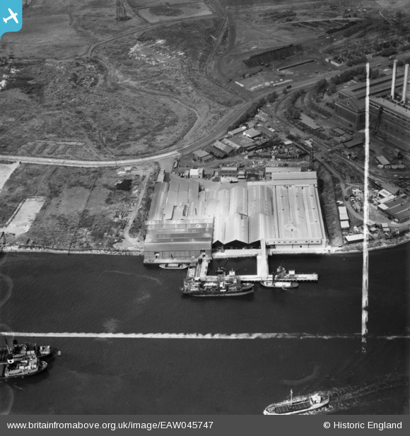
EAW045747 ENGLAND (1952). De Pass Fertilizers Ltd Factory, Creekmouth, 1952. This image was marked by Aerofilms Ltd for photo editing.
© Copyright OpenStreetMap contributors and licensed by the OpenStreetMap Foundation. 2026. Cartography is licensed as CC BY-SA.
Nearby Images (25)
Details
| Title | [EAW045747] De Pass Fertilizers Ltd Factory, Creekmouth, 1952. This image was marked by Aerofilms Ltd for photo editing. |
| Reference | EAW045747 |
| Date | 6-August-1952 |
| Link | |
| Place name | CREEKMOUTH |
| Parish | |
| District | |
| Country | ENGLAND |
| Easting / Northing | 546187, 181620 |
| Longitude / Latitude | 0.10701255552601, 51.514082536661 |
| National Grid Reference | TQ462816 |
Pins
Be the first to add a comment to this image!


![[EAW045747] De Pass Fertilizers Ltd Factory, Creekmouth, 1952. This image was marked by Aerofilms Ltd for photo editing.](http://britainfromabove.org.uk/sites/all/libraries/aerofilms-images/public/100x100/EAW/045/EAW045747.jpg)
![[EAW045744] De Pass Fertilizers Ltd Factory, Creekmouth, 1952. This image was marked by Aerofilms Ltd for photo editing.](http://britainfromabove.org.uk/sites/all/libraries/aerofilms-images/public/100x100/EAW/045/EAW045744.jpg)
![[EAW045743] De Pass Fertilizers Ltd Factory, Creekmouth, 1952. This image was marked by Aerofilms Ltd for photo editing.](http://britainfromabove.org.uk/sites/all/libraries/aerofilms-images/public/100x100/EAW/045/EAW045743.jpg)
![[EAW045746] De Pass Fertilizers Ltd Factory, Creekmouth, 1952. This image was marked by Aerofilms Ltd for photo editing.](http://britainfromabove.org.uk/sites/all/libraries/aerofilms-images/public/100x100/EAW/045/EAW045746.jpg)
![[EAW045750] De Pass Fertilizers Ltd Factory, Creekmouth, 1952. This image was marked by Aerofilms Ltd for photo editing.](http://britainfromabove.org.uk/sites/all/libraries/aerofilms-images/public/100x100/EAW/045/EAW045750.jpg)
![[EAW045749] De Pass Fertilizers Ltd Factory and the River Thames, Creekmouth, 1952. This image was marked by Aerofilms Ltd for photo editing.](http://britainfromabove.org.uk/sites/all/libraries/aerofilms-images/public/100x100/EAW/045/EAW045749.jpg)
![[EAW045745] De Pass Fertilizers Ltd Factory, Creekmouth, 1952. This image was marked by Aerofilms Ltd for photo editing.](http://britainfromabove.org.uk/sites/all/libraries/aerofilms-images/public/100x100/EAW/045/EAW045745.jpg)
![[EAW045748] De Pass Fertilizers Ltd Factory and part of the adjacent Power Station, Creekmouth, 1952. This image was marked by Aerofilms Ltd for photo editing.](http://britainfromabove.org.uk/sites/all/libraries/aerofilms-images/public/100x100/EAW/045/EAW045748.jpg)
![[EPW036779] The Lawes Chemical Co Works, the Barking Guano Works and environs, Creekmouth, from the south-east, 1931](http://britainfromabove.org.uk/sites/all/libraries/aerofilms-images/public/100x100/EPW/036/EPW036779.jpg)
![[EPW008728] Barking Power Station under construction, Creekmouth, 1923](http://britainfromabove.org.uk/sites/all/libraries/aerofilms-images/public/100x100/EPW/008/EPW008728.jpg)
![[EPW010670] Barking Power Station and the River Thames, Creekmouth, 1924](http://britainfromabove.org.uk/sites/all/libraries/aerofilms-images/public/100x100/EPW/010/EPW010670.jpg)
![[EPW008729] Barking Power Station under construction, Creekmouth, 1923](http://britainfromabove.org.uk/sites/all/libraries/aerofilms-images/public/100x100/EPW/008/EPW008729.jpg)
![[EPW010663] Barking Power Station, Creekmouth, from the south-west, 1924](http://britainfromabove.org.uk/sites/all/libraries/aerofilms-images/public/100x100/EPW/010/EPW010663.jpg)
![[EPW010671] Barking Power Station and the River Thames, Creekmouth, 1924](http://britainfromabove.org.uk/sites/all/libraries/aerofilms-images/public/100x100/EPW/010/EPW010671.jpg)
![[EPW009666] Barking Power Station under construction, Creekmouth, 1923](http://britainfromabove.org.uk/sites/all/libraries/aerofilms-images/public/100x100/EPW/009/EPW009666.jpg)
![[EPW032829] Barking Power Station, Creekmouth, 1930](http://britainfromabove.org.uk/sites/all/libraries/aerofilms-images/public/100x100/EPW/032/EPW032829.jpg)
![[EPW008725] Barking Power Station under construction, Creekmouth, 1923](http://britainfromabove.org.uk/sites/all/libraries/aerofilms-images/public/100x100/EPW/008/EPW008725.jpg)
![[EPW008726] Barking Power Station under construction, Creekmouth, 1923](http://britainfromabove.org.uk/sites/all/libraries/aerofilms-images/public/100x100/EPW/008/EPW008726.jpg)
![[EPW006139] Lawes Chemical Manure Co Ltd, Creekmouth, 1921](http://britainfromabove.org.uk/sites/all/libraries/aerofilms-images/public/100x100/EPW/006/EPW006139.jpg)
![[EPW021371] Barking Power Station under construction, Creekmouth, 1928](http://britainfromabove.org.uk/sites/all/libraries/aerofilms-images/public/100x100/EPW/021/EPW021371.jpg)
![[EPW010664] The River Thames at Barking Power Station, Creekmouth, 1924](http://britainfromabove.org.uk/sites/all/libraries/aerofilms-images/public/100x100/EPW/010/EPW010664.jpg)
![[EPW010667] Barking Power Station, Creekmouth, 1924](http://britainfromabove.org.uk/sites/all/libraries/aerofilms-images/public/100x100/EPW/010/EPW010667.jpg)
![[EPW009690] Barking Power Station under construction, Creekmouth, 1923](http://britainfromabove.org.uk/sites/all/libraries/aerofilms-images/public/100x100/EPW/009/EPW009690.jpg)
![[EPW009689] Barking Power Station under construction, Creekmouth, 1923](http://britainfromabove.org.uk/sites/all/libraries/aerofilms-images/public/100x100/EPW/009/EPW009689.jpg)
![[EPW010666] Barking Power Station, Creekmouth, 1924](http://britainfromabove.org.uk/sites/all/libraries/aerofilms-images/public/100x100/EPW/010/EPW010666.jpg)