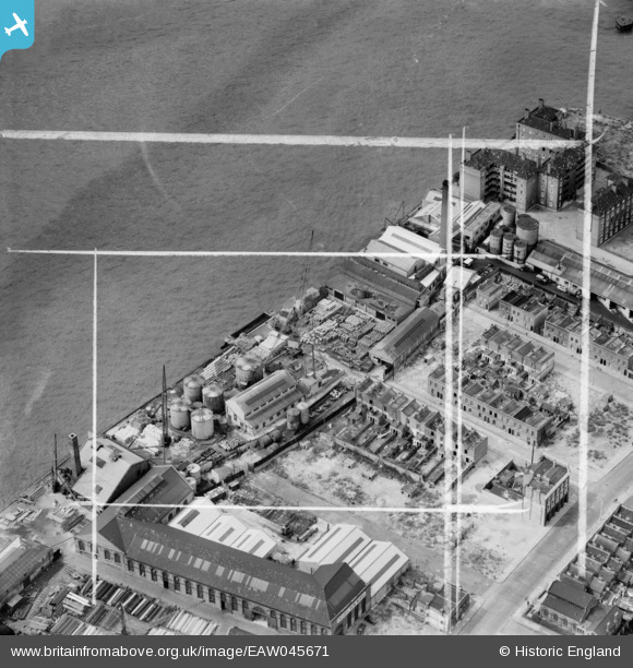
EAW045671 ENGLAND (1952). Winkley's Wharf, Isle of Dogs, 1952. This image was marked by Aerofilms Ltd for photo editing.
© Copyright OpenStreetMap contributors and licensed by the OpenStreetMap Foundation. 2026. Cartography is licensed as CC BY-SA.
Nearby Images (18)
Details
| Title | [EAW045671] Winkley's Wharf, Isle of Dogs, 1952. This image was marked by Aerofilms Ltd for photo editing. |
| Reference | EAW045671 |
| Date | 31-July-1952 |
| Link | |
| Place name | ISLE OF DOGS |
| Parish | |
| District | |
| Country | ENGLAND |
| Easting / Northing | 537104, 178885 |
| Longitude / Latitude | -0.02487871773081, 51.491780407033 |
| National Grid Reference | TQ371789 |
Pins

redmist |
Wednesday 20th of May 2020 07:13:34 PM |


![[EAW045671] Winkley's Wharf, Isle of Dogs, 1952. This image was marked by Aerofilms Ltd for photo editing.](http://britainfromabove.org.uk/sites/all/libraries/aerofilms-images/public/100x100/EAW/045/EAW045671.jpg)
![[EAW045668] Winkley's Wharf, Isle of Dogs, 1952. This image was marked by Aerofilms Ltd for photo editing.](http://britainfromabove.org.uk/sites/all/libraries/aerofilms-images/public/100x100/EAW/045/EAW045668.jpg)
![[EAW045665] Winkley's Wharf, Isle of Dogs, 1952. This image was marked by Aerofilms Ltd for photo editing.](http://britainfromabove.org.uk/sites/all/libraries/aerofilms-images/public/100x100/EAW/045/EAW045665.jpg)
![[EAW045664] Winkley's Wharf, Isle of Dogs, 1952. This image was marked by Aerofilms Ltd for photo editing.](http://britainfromabove.org.uk/sites/all/libraries/aerofilms-images/public/100x100/EAW/045/EAW045664.jpg)
![[EAW045669] Winkley's Wharf, Isle of Dogs, 1952. This image was marked by Aerofilms Ltd for photo editing.](http://britainfromabove.org.uk/sites/all/libraries/aerofilms-images/public/100x100/EAW/045/EAW045669.jpg)
![[EAW045667] Winkley's Wharf, Isle of Dogs, 1952. This image was marked by Aerofilms Ltd for photo editing.](http://britainfromabove.org.uk/sites/all/libraries/aerofilms-images/public/100x100/EAW/045/EAW045667.jpg)
![[EAW045670] Winkley's Wharf, Isle of Dogs, 1952. This image was marked by Aerofilms Ltd for photo editing.](http://britainfromabove.org.uk/sites/all/libraries/aerofilms-images/public/100x100/EAW/045/EAW045670.jpg)
![[EAW045672] Winkley's Wharf, Isle of Dogs, 1952. This image was marked by Aerofilms Ltd for photo editing.](http://britainfromabove.org.uk/sites/all/libraries/aerofilms-images/public/100x100/EAW/045/EAW045672.jpg)
![[EAW045666] Winkley's Wharf, Isle of Dogs, 1952. This image was marked by Aerofilms Ltd for photo editing.](http://britainfromabove.org.uk/sites/all/libraries/aerofilms-images/public/100x100/EAW/045/EAW045666.jpg)
![[EPW016693] The Edward Le Bas Cyclops Iron Works and environs, Millwall, 1926](http://britainfromabove.org.uk/sites/all/libraries/aerofilms-images/public/100x100/EPW/016/EPW016693.jpg)
![[EPW016691] Claude Street and environs, Millwall, 1926](http://britainfromabove.org.uk/sites/all/libraries/aerofilms-images/public/100x100/EPW/016/EPW016691.jpg)
![[EPW016692] Edward Le Bas Cyclops Iron Works and environs, Millwall, 1926](http://britainfromabove.org.uk/sites/all/libraries/aerofilms-images/public/100x100/EPW/016/EPW016692.jpg)
![[EPW015768] The River Thames and wharfage between Millwall Outer Dock and Greenwich Reach, Millwall, 1926. This image has been produced from a copy-negative.](http://britainfromabove.org.uk/sites/all/libraries/aerofilms-images/public/100x100/EPW/015/EPW015768.jpg)
![[EPW016688] Edward Le Bas and Co Cyclops Iron Works, Millwall, 1926](http://britainfromabove.org.uk/sites/all/libraries/aerofilms-images/public/100x100/EPW/016/EPW016688.jpg)
![[EPW016690] Edward Le Bas and Co Cyclops Iron Works, Millwall, 1926](http://britainfromabove.org.uk/sites/all/libraries/aerofilms-images/public/100x100/EPW/016/EPW016690.jpg)
![[EPW016687] Edward Le Bas and Co Cyclops Iron Works, Millwall, 1926](http://britainfromabove.org.uk/sites/all/libraries/aerofilms-images/public/100x100/EPW/016/EPW016687.jpg)
![[EPW015764] The River Thames at Winkley's Wharf and Victoria Wharf, Millwall, 1926. This image has been produced from a print.](http://britainfromabove.org.uk/sites/all/libraries/aerofilms-images/public/100x100/EPW/015/EPW015764.jpg)
![[EPW016689] Edward Le Bas and Co Cyclops Iron Works, Millwall, 1926](http://britainfromabove.org.uk/sites/all/libraries/aerofilms-images/public/100x100/EPW/016/EPW016689.jpg)