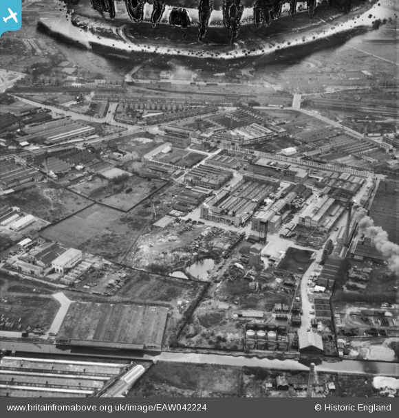
EAW042224 ENGLAND (1952). The Bakelite Ltd Works, Tyseley, 1952. This image has been produced from a damaged negative.
© Copyright OpenStreetMap contributors and licensed by the OpenStreetMap Foundation. 2026. Cartography is licensed as CC BY-SA.
Nearby Images (38)
Details
| Title | [EAW042224] The Bakelite Ltd Works, Tyseley, 1952. This image has been produced from a damaged negative. |
| Reference | EAW042224 |
| Date | 4-April-1952 |
| Link | |
| Place name | TYSELEY |
| Parish | |
| District | |
| Country | ENGLAND |
| Easting / Northing | 411362, 284332 |
| Longitude / Latitude | -1.8327729803989, 52.456449096887 |
| National Grid Reference | SP114843 |
Pins
Be the first to add a comment to this image!


![[EAW042224] The Bakelite Ltd Works, Tyseley, 1952. This image has been produced from a damaged negative.](http://britainfromabove.org.uk/sites/all/libraries/aerofilms-images/public/100x100/EAW/042/EAW042224.jpg)
![[EAW041905] The Bakelite Works off Redfern Road, Tyseley, 1952](http://britainfromabove.org.uk/sites/all/libraries/aerofilms-images/public/100x100/EAW/041/EAW041905.jpg)
![[EAW041908] The Bakelite Works off Redfern Road, Tyseley, 1952](http://britainfromabove.org.uk/sites/all/libraries/aerofilms-images/public/100x100/EAW/041/EAW041908.jpg)
![[EAW042225] The Bakelite Ltd Works, Tyseley, 1952. This image has been produced from a damaged negative.](http://britainfromabove.org.uk/sites/all/libraries/aerofilms-images/public/100x100/EAW/042/EAW042225.jpg)
![[EAW042222] The Bakelite Ltd Works, Tyseley, 1952. This image has been produced from a damaged negative.](http://britainfromabove.org.uk/sites/all/libraries/aerofilms-images/public/100x100/EAW/042/EAW042222.jpg)
![[EAW042223] The Bakelite Ltd Works, Tyseley, 1952. This image has been produced from a damaged negative.](http://britainfromabove.org.uk/sites/all/libraries/aerofilms-images/public/100x100/EAW/042/EAW042223.jpg)
![[EAW041907] The Bakelite Works off Redfern Road, Tyseley, 1952](http://britainfromabove.org.uk/sites/all/libraries/aerofilms-images/public/100x100/EAW/041/EAW041907.jpg)
![[EAW041912] The Bakelite Works off Redfern Road, Tyseley, 1952](http://britainfromabove.org.uk/sites/all/libraries/aerofilms-images/public/100x100/EAW/041/EAW041912.jpg)
![[EAW041906] The Bakelite Works off Redfern Road, Tyseley, 1952](http://britainfromabove.org.uk/sites/all/libraries/aerofilms-images/public/100x100/EAW/041/EAW041906.jpg)
![[EAW042228] The Bakelite Ltd Works, Tyseley, 1952. This image has been produced from a damaged negative.](http://britainfromabove.org.uk/sites/all/libraries/aerofilms-images/public/100x100/EAW/042/EAW042228.jpg)
![[EAW042220] The Bakelite Ltd Works, Tyseley, 1952. This image has been produced from a damaged negative.](http://britainfromabove.org.uk/sites/all/libraries/aerofilms-images/public/100x100/EAW/042/EAW042220.jpg)
![[EAW042221] The Bakelite Ltd Works, Tyseley, 1952. This image has been produced from a damaged negative.](http://britainfromabove.org.uk/sites/all/libraries/aerofilms-images/public/100x100/EAW/042/EAW042221.jpg)
![[EAW041909] The Bakelite Works off Redfern Road, Tyseley, 1952](http://britainfromabove.org.uk/sites/all/libraries/aerofilms-images/public/100x100/EAW/041/EAW041909.jpg)
![[EAW041911] The Bakelite Works off Redfern Road, Tyseley, 1952](http://britainfromabove.org.uk/sites/all/libraries/aerofilms-images/public/100x100/EAW/041/EAW041911.jpg)
![[EAW041910] The Bakelite Works off Redfern Road, Tyseley, 1952](http://britainfromabove.org.uk/sites/all/libraries/aerofilms-images/public/100x100/EAW/041/EAW041910.jpg)
![[EAW042227] The Bakelite Ltd Works, Tyseley, 1952. This image has been produced from a damaged negative.](http://britainfromabove.org.uk/sites/all/libraries/aerofilms-images/public/100x100/EAW/042/EAW042227.jpg)
![[EAW042226] The Bakelite Ltd Works, Tyseley, 1952. This image has been produced from a damaged negative.](http://britainfromabove.org.uk/sites/all/libraries/aerofilms-images/public/100x100/EAW/042/EAW042226.jpg)
![[EPW044572] The Bakelite Works alongside the Grand Union Canal, Tyseley, 1934](http://britainfromabove.org.uk/sites/all/libraries/aerofilms-images/public/100x100/EPW/044/EPW044572.jpg)
![[EAW000199] The Bakelite Works and the surrounding industrial area, Tyseley, 1946. This image has been produced from a damaged negative.](http://britainfromabove.org.uk/sites/all/libraries/aerofilms-images/public/100x100/EAW/000/EAW000199.jpg)
![[EAW000200] The Bakelite Works, Tyseley, 1946. This image has been produced from a damaged negative.](http://britainfromabove.org.uk/sites/all/libraries/aerofilms-images/public/100x100/EAW/000/EAW000200.jpg)
![[EPW044575] The Bakelite Works between Redfern Road and the Grand Union Canal, Tyseley, 1934](http://britainfromabove.org.uk/sites/all/libraries/aerofilms-images/public/100x100/EPW/044/EPW044575.jpg)
![[EPW044573] The Bakelite Works alongside the Grand Union Canal, Tyseley, 1934. This image has been affected by flare.](http://britainfromabove.org.uk/sites/all/libraries/aerofilms-images/public/100x100/EPW/044/EPW044573.jpg)
![[EAW000196] The Bakelite Works and the surrounding industrial area, Tyseley, 1946. This image has been produced from a damaged negative.](http://britainfromabove.org.uk/sites/all/libraries/aerofilms-images/public/100x100/EAW/000/EAW000196.jpg)
![[EAW000201] The Bakelite Works and the surrounding industrial area, Tyseley, 1946. This image has been produced from a damaged negative.](http://britainfromabove.org.uk/sites/all/libraries/aerofilms-images/public/100x100/EAW/000/EAW000201.jpg)
![[EPW044570] The Bakelite Works, Tyseley, 1934](http://britainfromabove.org.uk/sites/all/libraries/aerofilms-images/public/100x100/EPW/044/EPW044570.jpg)
![[EAW042229] The Bakelite Ltd Works, Tyseley, from the south-west, 1952. This image has been produced from a damaged negative.](http://britainfromabove.org.uk/sites/all/libraries/aerofilms-images/public/100x100/EAW/042/EAW042229.jpg)
![[EAW000197] The Bakelite Works and the surrounding industrial area, Tyseley, 1946. This image has been produced from a damaged negative.](http://britainfromabove.org.uk/sites/all/libraries/aerofilms-images/public/100x100/EAW/000/EAW000197.jpg)
![[EAW000195] The Bakelite Works and the surrounding industrial area, Tyseley, 1946. This image has been produced from a damaged negative.](http://britainfromabove.org.uk/sites/all/libraries/aerofilms-images/public/100x100/EAW/000/EAW000195.jpg)
![[EAW000203] The Bakelite Works and the residential area at Stockfield, Tyseley, from the north-west, 1946. This image has been produced from a damaged negative.](http://britainfromabove.org.uk/sites/all/libraries/aerofilms-images/public/100x100/EAW/000/EAW000203.jpg)
![[EPW044569] The Bakelite Works between Redfern Road and the Grand Union Canal, Tyseley, 1934](http://britainfromabove.org.uk/sites/all/libraries/aerofilms-images/public/100x100/EPW/044/EPW044569.jpg)
![[EPW044576] The Bakelite Works between Redfern Road and the Grand Union Canal, Tyseley, 1934](http://britainfromabove.org.uk/sites/all/libraries/aerofilms-images/public/100x100/EPW/044/EPW044576.jpg)
![[EAW000194] The Bakelite Works and the surrounding industrial area, Tyseley, 1946. This image has been produced from a damaged negative.](http://britainfromabove.org.uk/sites/all/libraries/aerofilms-images/public/100x100/EAW/000/EAW000194.jpg)
![[EPW044568] The Bakelite Works alongside Kings Road and the Grand Union Canal, Tyseley, 1934](http://britainfromabove.org.uk/sites/all/libraries/aerofilms-images/public/100x100/EPW/044/EPW044568.jpg)
![[EPW044574] The Bakelite Works between Redfern Road and the Grand Union Canal, Tyseley, 1934](http://britainfromabove.org.uk/sites/all/libraries/aerofilms-images/public/100x100/EPW/044/EPW044574.jpg)
![[EAW000198] The Bakelite Works and the surrounding industrial area, Tyseley, 1946. This image has been produced from a damaged negative.](http://britainfromabove.org.uk/sites/all/libraries/aerofilms-images/public/100x100/EAW/000/EAW000198.jpg)
![[EAW000202] The Bakelite Works and the surrounding industrial area, Tyseley, 1946. This image has been produced from a damaged negative.](http://britainfromabove.org.uk/sites/all/libraries/aerofilms-images/public/100x100/EAW/000/EAW000202.jpg)
![[EPW044571] The Bakelite Works between Redfern Road and the Grand Union Canal, Tyseley, 1934](http://britainfromabove.org.uk/sites/all/libraries/aerofilms-images/public/100x100/EPW/044/EPW044571.jpg)
![[EPW061222] The Rover Motor Co Works site and housing at Sunningdale Road, Hay Mills, 1939](http://britainfromabove.org.uk/sites/all/libraries/aerofilms-images/public/100x100/EPW/061/EPW061222.jpg)