
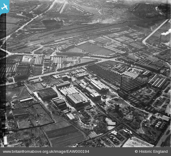
EAW000194 ENGLAND (1946). The Bakelite Works and the surrounding industrial area, Tyseley, 1946. This image has been produced from a damaged negative.
© Copyright OpenStreetMap contributors and licensed by the OpenStreetMap Foundation. 2026. Cartography is licensed as CC BY-SA.
Nearby Images (48)
EAW000194

EAW000196

EPW044570

EAW042229

EAW041911

EAW000203

EAW041909

EAW042221

EPW044576

EAW042220

EAW042228

EAW000202

EAW000195

EPW044568

EPW044569

EAW000200

EAW000197

EPW061222

EPW061227

EAW042223

EAW041910

EAW041907

EPW044575

EAW029657
, Tyseley, 1950. This image has been produced from a print marked by Aerofilms Ltd for photo editing.")
EAW042222

EAW029663
 and environs, Tyseley, 1950. This image has been produced from a print marked by Aerofilms Ltd for photo editing.")
EAW041912

EAW029658
 and environs, Tyseley, 1950. This image has been produced from a print marked by Aerofilms Ltd for photo editing.")
EAW041906

EPW044573

EAW029665
 and environs, Tyseley, 1950. This image has been produced from a print marked by Aerofilms Ltd for photo editing.")
EPW044574

EAW029659
 and environs, Tyseley, 1950. This image has been produced from a print marked by Aerofilms Ltd for photo editing.")
EAW041905

EAW000199

EAW042224

EAW000201

EAW029660
 and environs, Tyseley, 1950. This image has been produced from a print marked by Aerofilms Ltd for photo editing.")
EAW029664
 and environs, Tyseley, 1950. This image has been produced from a print marked by Aerofilms Ltd for photo editing.")
EPW061224

EAW029661
 and environs, Tyseley, 1950. This image has been produced from a print marked by Aerofilms Ltd for photo editing.")
EAW041908

EPW044572

EAW000198

EAW029662
 and environs, Tyseley, 1950. This image has been produced from a print marked by Aerofilms Ltd for photo editing.")
EPW044571

EPW061228

EPW061229

Details
| Title | [EAW000194] The Bakelite Works and the surrounding industrial area, Tyseley, 1946. This image has been produced from a damaged negative. |
| Reference | EAW000194 |
| Date | 16-April-1946 |
| Link | |
| Place name | TYSELEY |
| Parish | |
| District | |
| Country | ENGLAND |
| Easting / Northing | 411157, 284351 |
| Longitude / Latitude | -1.8357895412528, 52.456624152935 |
| National Grid Reference | SP112844 |
Pins

Chris |
Saturday 17th of May 2014 08:22:46 PM | |
|
Chris |
Saturday 17th of May 2014 08:16:34 PM | |
|
Chris |
Saturday 17th of May 2014 08:15:19 PM | |

Class31 |
Tuesday 22nd of October 2013 12:04:56 PM | |
|
Class31 |
Tuesday 22nd of October 2013 11:56:49 AM | |
|
Class31 |
Tuesday 22nd of October 2013 11:48:33 AM | |
|
Ron41 |
Sunday 8th of September 2013 12:17:00 PM | |
|
Ron41 |
Sunday 8th of September 2013 12:15:10 PM | |
|
Ron41 |
Sunday 8th of September 2013 12:11:43 PM | |
|
Ron41 |
Sunday 8th of September 2013 12:11:09 PM | |
|
Ron41 |
Sunday 8th of September 2013 12:09:03 PM |