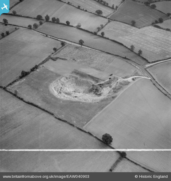
EAW040903 ENGLAND (1951). The Birch Pit (sand and gravel), Birch, 1951. This image was marked by Aerofilms Ltd for photo editing.
© Copyright OpenStreetMap contributors and licensed by the OpenStreetMap Foundation. 2026. Cartography is licensed as CC BY-SA.
Nearby Images (11)
Details
| Title | [EAW040903] The Birch Pit (sand and gravel), Birch, 1951. This image was marked by Aerofilms Ltd for photo editing. |
| Reference | EAW040903 |
| Date | 18-October-1951 |
| Link | |
| Place name | BIRCH |
| Parish | BIRCH |
| District | |
| Country | ENGLAND |
| Easting / Northing | 592776, 219357 |
| Longitude / Latitude | 0.79858427082073, 51.839046975055 |
| National Grid Reference | TL928194 |
Pins

redmist |
Tuesday 11th of October 2022 09:42:52 AM |


![[EAW040903] The Birch Pit (sand and gravel), Birch, 1951. This image was marked by Aerofilms Ltd for photo editing.](http://britainfromabove.org.uk/sites/all/libraries/aerofilms-images/public/100x100/EAW/040/EAW040903.jpg)
![[EAW040904] The Birch Pit (sand and gravel), Birch, 1951. This image was marked by Aerofilms Ltd for photo editing.](http://britainfromabove.org.uk/sites/all/libraries/aerofilms-images/public/100x100/EAW/040/EAW040904.jpg)
![[EAW040905] The Birch Pit (sand and gravel), Birch, 1951. This image was marked by Aerofilms Ltd for photo editing.](http://britainfromabove.org.uk/sites/all/libraries/aerofilms-images/public/100x100/EAW/040/EAW040905.jpg)
![[EAW040914] The Birch Pit (sand and gravel) alongside Birch Airfield, Birch, 1951. This image was marked by Aerofilms Ltd for photo editing.](http://britainfromabove.org.uk/sites/all/libraries/aerofilms-images/public/100x100/EAW/040/EAW040914.jpg)
![[EAW040913] The Birch Pit (sand and gravel) alongside Birch Airfield, Birch, 1951. This image was marked by Aerofilms Ltd for photo editing.](http://britainfromabove.org.uk/sites/all/libraries/aerofilms-images/public/100x100/EAW/040/EAW040913.jpg)
![[EAW040907] The Birch Pit (sand and gravel) alongside Birch Airfield, Birch, 1951. This image was marked by Aerofilms Ltd for photo editing.](http://britainfromabove.org.uk/sites/all/libraries/aerofilms-images/public/100x100/EAW/040/EAW040907.jpg)
![[EAW040906] The Birch Pit (sand and gravel) alongside Birch Airfield, Birch, 1951. This image was marked by Aerofilms Ltd for photo editing.](http://britainfromabove.org.uk/sites/all/libraries/aerofilms-images/public/100x100/EAW/040/EAW040906.jpg)
![[EAW041057] Birch Gravel Pit by Roundbush Corner and Birch Airfield, Birch, 1951](http://britainfromabove.org.uk/sites/all/libraries/aerofilms-images/public/100x100/EAW/041/EAW041057.jpg)
![[EAW040910] The Birch Pit (sand and gravel) alongside Birch Airfield, Birch, 1951. This image was marked by Aerofilms Ltd for photo editing.](http://britainfromabove.org.uk/sites/all/libraries/aerofilms-images/public/100x100/EAW/040/EAW040910.jpg)
![[EAW041056] Birch Gravel Pit by Roundbush Corner and Birch Airfield, Birch, 1951. This image was marked by Aerofilms Ltd for photo editing.](http://britainfromabove.org.uk/sites/all/libraries/aerofilms-images/public/100x100/EAW/041/EAW041056.jpg)
![[EAW041055] Birch Gravel Pit by Roundbush Corner and Birch Airfield, Birch, 1951. This image was marked by Aerofilms Ltd for photo editing.](http://britainfromabove.org.uk/sites/all/libraries/aerofilms-images/public/100x100/EAW/041/EAW041055.jpg)