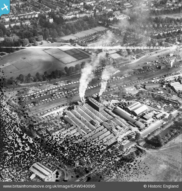
EAW040095 ENGLAND (1951). The Imperial Foundry, the station sidings and Victoria Park, Royal Leamington Spa, 1951. This image has been produced from a damaged negative.
© Copyright OpenStreetMap contributors and licensed by the OpenStreetMap Foundation. 2026. Cartography is licensed as CC BY-SA.
Nearby Images (19)
Details
| Title | [EAW040095] The Imperial Foundry, the station sidings and Victoria Park, Royal Leamington Spa, 1951. This image has been produced from a damaged negative. |
| Reference | EAW040095 |
| Date | 26-September-1951 |
| Link | |
| Place name | ROYAL LEAMINGTON SPA |
| Parish | ROYAL LEAMINGTON SPA |
| District | |
| Country | ENGLAND |
| Easting / Northing | 431155, 265301 |
| Longitude / Latitude | -1.5432330070676, 52.284572978721 |
| National Grid Reference | SP312653 |


![[EAW040095] The Imperial Foundry, the station sidings and Victoria Park, Royal Leamington Spa, 1951. This image has been produced from a damaged negative.](http://britainfromabove.org.uk/sites/all/libraries/aerofilms-images/public/100x100/EAW/040/EAW040095.jpg)
![[EAW000234] The Ford Motor Company factory on Prince's Drive and environs, Royal Leamington Spa, 1946](http://britainfromabove.org.uk/sites/all/libraries/aerofilms-images/public/100x100/EAW/000/EAW000234.jpg)
![[EAW040094] The Imperial Foundry and station sidings, Royal Leamington Spa, 1951. This image was marked by Aerofilms Ltd for photo editing.](http://britainfromabove.org.uk/sites/all/libraries/aerofilms-images/public/100x100/EAW/040/EAW040094.jpg)
![[EAW000238] The Ford Motor Company factory on Prince's Drive and environs, Royal Leamington Spa, 1946](http://britainfromabove.org.uk/sites/all/libraries/aerofilms-images/public/100x100/EAW/000/EAW000238.jpg)
![[EAW000233] The Ford Motor Company factory on Prince's Drive and environs, Royal Leamington Spa, 1946](http://britainfromabove.org.uk/sites/all/libraries/aerofilms-images/public/100x100/EAW/000/EAW000233.jpg)
![[EAW000237] The Ford Motor Company factory on Prince's Drive and environs, Royal Leamington Spa, 1946](http://britainfromabove.org.uk/sites/all/libraries/aerofilms-images/public/100x100/EAW/000/EAW000237.jpg)
![[EPW053196] The Sidney Flavel and Co Imperial Stove Works, Royal Leamington Spa, 1937](http://britainfromabove.org.uk/sites/all/libraries/aerofilms-images/public/100x100/EPW/053/EPW053196.jpg)
![[EAW000232] The Ford Motor Company factory on Prince's Drive and environs, Royal Leamington Spa, 1946](http://britainfromabove.org.uk/sites/all/libraries/aerofilms-images/public/100x100/EAW/000/EAW000232.jpg)
![[EAW000236] The Ford Motor Company factory on Prince's Drive, Royal Leamington Spa, 1946](http://britainfromabove.org.uk/sites/all/libraries/aerofilms-images/public/100x100/EAW/000/EAW000236.jpg)
![[EAW040096] The Imperial Foundry and Grand Union Canal, Royal Leamington Spa, 1951. This image has been produced from a damaged negative.](http://britainfromabove.org.uk/sites/all/libraries/aerofilms-images/public/100x100/EAW/040/EAW040096.jpg)
![[EPW053195] The Sidney Flavel and Co Imperial Stove Works, Royal Leamington Spa, 1937](http://britainfromabove.org.uk/sites/all/libraries/aerofilms-images/public/100x100/EPW/053/EPW053195.jpg)
![[EPW053199] The Sidney Flavel and Co Imperial Stove Works, Royal Leamington Spa, 1937](http://britainfromabove.org.uk/sites/all/libraries/aerofilms-images/public/100x100/EPW/053/EPW053199.jpg)
![[EPW019737] Victoria Park, Royal Leamington Spa, 1927](http://britainfromabove.org.uk/sites/all/libraries/aerofilms-images/public/100x100/EPW/019/EPW019737.jpg)
![[EPW053200] The Sidney Flavel and Co Imperial Stove Works, Royal Leamington Spa, 1937](http://britainfromabove.org.uk/sites/all/libraries/aerofilms-images/public/100x100/EPW/053/EPW053200.jpg)
![[EAW000235] The Ford Motor Company factory on Prince's Drive, Royal Leamington Spa, 1946](http://britainfromabove.org.uk/sites/all/libraries/aerofilms-images/public/100x100/EAW/000/EAW000235.jpg)
![[EAW000149] The Imperial (Ford) Foundry off Prince's Drive, Royal Leamington Spa, 1946](http://britainfromabove.org.uk/sites/all/libraries/aerofilms-images/public/100x100/EAW/000/EAW000149.jpg)
![[EPW053197] The Sidney Flavel and Co Imperial Stove Works, Royal Leamington Spa, 1937](http://britainfromabove.org.uk/sites/all/libraries/aerofilms-images/public/100x100/EPW/053/EPW053197.jpg)
![[EPW053198] The Sidney Flavel and Co Imperial Stove Works, Royal Leamington Spa, 1937](http://britainfromabove.org.uk/sites/all/libraries/aerofilms-images/public/100x100/EPW/053/EPW053198.jpg)
![[EAW000150] The Imperial (Ford) Foundry off Prince's Drive, Royal Leamington Spa, 1946](http://britainfromabove.org.uk/sites/all/libraries/aerofilms-images/public/100x100/EAW/000/EAW000150.jpg)

