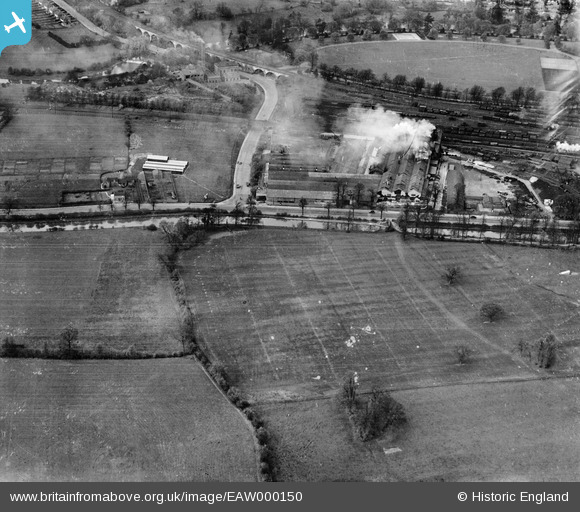
EAW000150 ENGLAND (1946). The Imperial (Ford) Foundry off Prince's Drive, Royal Leamington Spa, 1946
© Copyright OpenStreetMap contributors and licensed by the OpenStreetMap Foundation. 2026. Cartography is licensed as CC BY-SA.
Nearby Images (18)
Details
| Title | [EAW000150] The Imperial (Ford) Foundry off Prince's Drive, Royal Leamington Spa, 1946 |
| Reference | EAW000150 |
| Date | 9-April-1946 |
| Link | |
| Place name | ROYAL LEAMINGTON SPA |
| Parish | ROYAL LEAMINGTON SPA |
| District | |
| Country | ENGLAND |
| Easting / Northing | 431049, 265082 |
| Longitude / Latitude | -1.5448072099665, 52.282609944864 |
| National Grid Reference | SP310651 |
Pins

Matt Aldred edob.mattaldred.com |
Thursday 19th of May 2022 04:39:19 PM |


![[EAW000150] The Imperial (Ford) Foundry off Prince's Drive, Royal Leamington Spa, 1946](http://britainfromabove.org.uk/sites/all/libraries/aerofilms-images/public/100x100/EAW/000/EAW000150.jpg)
![[EPW053198] The Sidney Flavel and Co Imperial Stove Works, Royal Leamington Spa, 1937](http://britainfromabove.org.uk/sites/all/libraries/aerofilms-images/public/100x100/EPW/053/EPW053198.jpg)
![[EPW053197] The Sidney Flavel and Co Imperial Stove Works, Royal Leamington Spa, 1937](http://britainfromabove.org.uk/sites/all/libraries/aerofilms-images/public/100x100/EPW/053/EPW053197.jpg)
![[EPW053200] The Sidney Flavel and Co Imperial Stove Works, Royal Leamington Spa, 1937](http://britainfromabove.org.uk/sites/all/libraries/aerofilms-images/public/100x100/EPW/053/EPW053200.jpg)
![[EAW040096] The Imperial Foundry and Grand Union Canal, Royal Leamington Spa, 1951. This image has been produced from a damaged negative.](http://britainfromabove.org.uk/sites/all/libraries/aerofilms-images/public/100x100/EAW/040/EAW040096.jpg)
![[EPW053199] The Sidney Flavel and Co Imperial Stove Works, Royal Leamington Spa, 1937](http://britainfromabove.org.uk/sites/all/libraries/aerofilms-images/public/100x100/EPW/053/EPW053199.jpg)
![[EAW000149] The Imperial (Ford) Foundry off Prince's Drive, Royal Leamington Spa, 1946](http://britainfromabove.org.uk/sites/all/libraries/aerofilms-images/public/100x100/EAW/000/EAW000149.jpg)
![[EAW000232] The Ford Motor Company factory on Prince's Drive and environs, Royal Leamington Spa, 1946](http://britainfromabove.org.uk/sites/all/libraries/aerofilms-images/public/100x100/EAW/000/EAW000232.jpg)
![[EAW000236] The Ford Motor Company factory on Prince's Drive, Royal Leamington Spa, 1946](http://britainfromabove.org.uk/sites/all/libraries/aerofilms-images/public/100x100/EAW/000/EAW000236.jpg)
![[EPW053195] The Sidney Flavel and Co Imperial Stove Works, Royal Leamington Spa, 1937](http://britainfromabove.org.uk/sites/all/libraries/aerofilms-images/public/100x100/EPW/053/EPW053195.jpg)
![[EPW053196] The Sidney Flavel and Co Imperial Stove Works, Royal Leamington Spa, 1937](http://britainfromabove.org.uk/sites/all/libraries/aerofilms-images/public/100x100/EPW/053/EPW053196.jpg)
![[EAW000233] The Ford Motor Company factory on Prince's Drive and environs, Royal Leamington Spa, 1946](http://britainfromabove.org.uk/sites/all/libraries/aerofilms-images/public/100x100/EAW/000/EAW000233.jpg)
![[EAW000238] The Ford Motor Company factory on Prince's Drive and environs, Royal Leamington Spa, 1946](http://britainfromabove.org.uk/sites/all/libraries/aerofilms-images/public/100x100/EAW/000/EAW000238.jpg)
![[EAW000235] The Ford Motor Company factory on Prince's Drive, Royal Leamington Spa, 1946](http://britainfromabove.org.uk/sites/all/libraries/aerofilms-images/public/100x100/EAW/000/EAW000235.jpg)
![[EAW000237] The Ford Motor Company factory on Prince's Drive and environs, Royal Leamington Spa, 1946](http://britainfromabove.org.uk/sites/all/libraries/aerofilms-images/public/100x100/EAW/000/EAW000237.jpg)
![[EAW040094] The Imperial Foundry and station sidings, Royal Leamington Spa, 1951. This image was marked by Aerofilms Ltd for photo editing.](http://britainfromabove.org.uk/sites/all/libraries/aerofilms-images/public/100x100/EAW/040/EAW040094.jpg)
![[EAW040095] The Imperial Foundry, the station sidings and Victoria Park, Royal Leamington Spa, 1951. This image has been produced from a damaged negative.](http://britainfromabove.org.uk/sites/all/libraries/aerofilms-images/public/100x100/EAW/040/EAW040095.jpg)
![[EAW000234] The Ford Motor Company factory on Prince's Drive and environs, Royal Leamington Spa, 1946](http://britainfromabove.org.uk/sites/all/libraries/aerofilms-images/public/100x100/EAW/000/EAW000234.jpg)