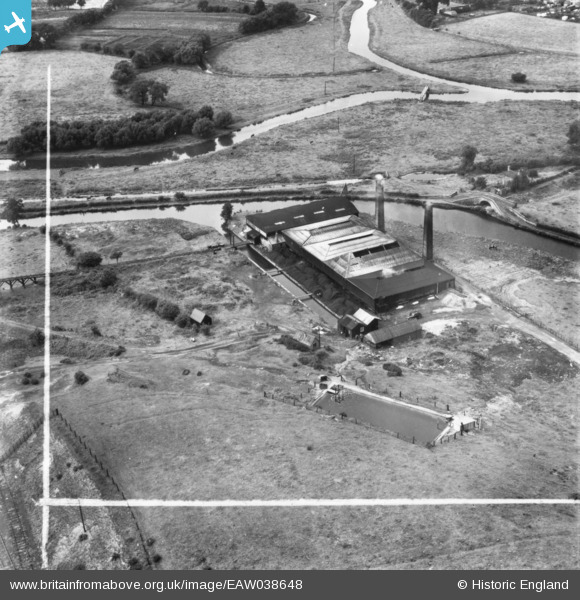
EAW038648 ENGLAND (1951). Baswich Salt Works, Baswich, 1951. This image has been produced from a print marked by Aerofilms Ltd for photo editing.
© Copyright OpenStreetMap contributors and licensed by the OpenStreetMap Foundation. 2026. Cartography is licensed as CC BY-SA.
Nearby Images (10)
Details
| Title | [EAW038648] Baswich Salt Works, Baswich, 1951. This image has been produced from a print marked by Aerofilms Ltd for photo editing. |
| Reference | EAW038648 |
| Date | 14-August-1951 |
| Link | |
| Place name | BASWICH |
| Parish | |
| District | |
| Country | ENGLAND |
| Easting / Northing | 394429, 322639 |
| Longitude / Latitude | -2.0826409362743, 52.800948386269 |
| National Grid Reference | SJ944226 |
Pins

David |
Sunday 21st of December 2014 11:48:56 PM | |

David |
Sunday 21st of December 2014 11:47:18 PM | |

David |
Sunday 21st of December 2014 11:45:58 PM | |

David |
Sunday 21st of December 2014 11:44:07 PM | |

David |
Sunday 21st of December 2014 11:42:57 PM | |

David |
Sunday 21st of December 2014 04:59:15 PM | |

David |
Sunday 21st of December 2014 04:57:19 PM | |

David |
Sunday 21st of December 2014 04:52:46 PM | |

David |
Sunday 21st of December 2014 02:45:32 PM | |

David |
Sunday 21st of December 2014 12:27:45 PM | |

David |
Sunday 21st of December 2014 12:09:48 PM |


![[EAW038648] Baswich Salt Works, Baswich, 1951. This image has been produced from a print marked by Aerofilms Ltd for photo editing.](http://britainfromabove.org.uk/sites/all/libraries/aerofilms-images/public/100x100/EAW/038/EAW038648.jpg)
![[EAW038643] Baswich Salt Works, Baswich, 1951. This image has been produced from a print marked by Aerofilms Ltd for photo editing.](http://britainfromabove.org.uk/sites/all/libraries/aerofilms-images/public/100x100/EAW/038/EAW038643.jpg)
![[EAW038646] Baswich Salt Works, Baswich, 1951. This image has been produced from a print marked by Aerofilms Ltd for photo editing.](http://britainfromabove.org.uk/sites/all/libraries/aerofilms-images/public/100x100/EAW/038/EAW038646.jpg)
![[EAW038647] Baswich Salt Works, Baswich, 1951. This image has been produced from a print marked by Aerofilms Ltd for photo editing.](http://britainfromabove.org.uk/sites/all/libraries/aerofilms-images/public/100x100/EAW/038/EAW038647.jpg)
![[EAW038653] Baswich Salt Works, Baswich, 1951. This image has been produced from a print.](http://britainfromabove.org.uk/sites/all/libraries/aerofilms-images/public/100x100/EAW/038/EAW038653.jpg)
![[EAW038654] Baswich Salt Works, Baswich, 1951. This image has been produced from a print.](http://britainfromabove.org.uk/sites/all/libraries/aerofilms-images/public/100x100/EAW/038/EAW038654.jpg)
![[EAW038652] Baswich Salt Works, Baswich, 1951. This image has been produced from a print marked by Aerofilms Ltd for photo editing.](http://britainfromabove.org.uk/sites/all/libraries/aerofilms-images/public/100x100/EAW/038/EAW038652.jpg)
![[EAW038650] Baswich Salt Works, Baswich, 1951. This image has been produced from a print.](http://britainfromabove.org.uk/sites/all/libraries/aerofilms-images/public/100x100/EAW/038/EAW038650.jpg)
![[EAW038649] Baswich Salt Works, Baswich, 1951. This image has been produced from a print marked by Aerofilms Ltd for photo editing.](http://britainfromabove.org.uk/sites/all/libraries/aerofilms-images/public/100x100/EAW/038/EAW038649.jpg)
![[EAW038651] Baswich Salt Works, Baswich, 1951. This image has been produced from a print.](http://britainfromabove.org.uk/sites/all/libraries/aerofilms-images/public/100x100/EAW/038/EAW038651.jpg)