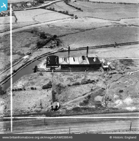
EAW038646 ENGLAND (1951). Baswich Salt Works, Baswich, 1951. This image has been produced from a print marked by Aerofilms Ltd for photo editing.
© Copyright OpenStreetMap contributors and licensed by the OpenStreetMap Foundation. 2026. Cartography is licensed as CC BY-SA.
Nearby Images (10)
Details
| Title | [EAW038646] Baswich Salt Works, Baswich, 1951. This image has been produced from a print marked by Aerofilms Ltd for photo editing. |
| Reference | EAW038646 |
| Date | 14-August-1951 |
| Link | |
| Place name | BASWICH |
| Parish | |
| District | |
| Country | ENGLAND |
| Easting / Northing | 394411, 322651 |
| Longitude / Latitude | -2.0829081554793, 52.801056086164 |
| National Grid Reference | SJ944227 |
Pins

David |
Monday 8th of February 2016 12:49:03 AM | |

David |
Sunday 21st of December 2014 05:39:33 PM | |

David |
Sunday 21st of December 2014 05:31:57 PM | |

David |
Sunday 21st of December 2014 05:30:01 PM | |

David |
Sunday 21st of December 2014 05:26:43 PM | |

David |
Sunday 21st of December 2014 05:15:55 PM | |

David |
Sunday 21st of December 2014 05:14:43 PM | |

David |
Sunday 21st of December 2014 05:09:15 PM | |

David |
Sunday 21st of December 2014 12:20:04 PM |


![[EAW038646] Baswich Salt Works, Baswich, 1951. This image has been produced from a print marked by Aerofilms Ltd for photo editing.](http://britainfromabove.org.uk/sites/all/libraries/aerofilms-images/public/100x100/EAW/038/EAW038646.jpg)
![[EAW038652] Baswich Salt Works, Baswich, 1951. This image has been produced from a print marked by Aerofilms Ltd for photo editing.](http://britainfromabove.org.uk/sites/all/libraries/aerofilms-images/public/100x100/EAW/038/EAW038652.jpg)
![[EAW038654] Baswich Salt Works, Baswich, 1951. This image has been produced from a print.](http://britainfromabove.org.uk/sites/all/libraries/aerofilms-images/public/100x100/EAW/038/EAW038654.jpg)
![[EAW038648] Baswich Salt Works, Baswich, 1951. This image has been produced from a print marked by Aerofilms Ltd for photo editing.](http://britainfromabove.org.uk/sites/all/libraries/aerofilms-images/public/100x100/EAW/038/EAW038648.jpg)
![[EAW038643] Baswich Salt Works, Baswich, 1951. This image has been produced from a print marked by Aerofilms Ltd for photo editing.](http://britainfromabove.org.uk/sites/all/libraries/aerofilms-images/public/100x100/EAW/038/EAW038643.jpg)
![[EAW038647] Baswich Salt Works, Baswich, 1951. This image has been produced from a print marked by Aerofilms Ltd for photo editing.](http://britainfromabove.org.uk/sites/all/libraries/aerofilms-images/public/100x100/EAW/038/EAW038647.jpg)
![[EAW038653] Baswich Salt Works, Baswich, 1951. This image has been produced from a print.](http://britainfromabove.org.uk/sites/all/libraries/aerofilms-images/public/100x100/EAW/038/EAW038653.jpg)
![[EAW038650] Baswich Salt Works, Baswich, 1951. This image has been produced from a print.](http://britainfromabove.org.uk/sites/all/libraries/aerofilms-images/public/100x100/EAW/038/EAW038650.jpg)
![[EAW038649] Baswich Salt Works, Baswich, 1951. This image has been produced from a print marked by Aerofilms Ltd for photo editing.](http://britainfromabove.org.uk/sites/all/libraries/aerofilms-images/public/100x100/EAW/038/EAW038649.jpg)
![[EAW038651] Baswich Salt Works, Baswich, 1951. This image has been produced from a print.](http://britainfromabove.org.uk/sites/all/libraries/aerofilms-images/public/100x100/EAW/038/EAW038651.jpg)