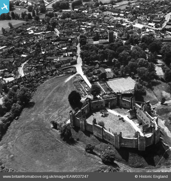
EAW037247 ENGLAND (1951). Framlingham Castle and town, Framlingham, 1951. This image has been produced from a print.
© Copyright OpenStreetMap contributors and licensed by the OpenStreetMap Foundation. 2026. Cartography is licensed as CC BY-SA.
Nearby Images (24)
Details
| Title | [EAW037247] Framlingham Castle and town, Framlingham, 1951. This image has been produced from a print. |
| Reference | EAW037247 |
| Date | 21-June-1951 |
| Link | |
| Place name | FRAMLINGHAM |
| Parish | FRAMLINGHAM |
| District | |
| Country | ENGLAND |
| Easting / Northing | 628646, 263615 |
| Longitude / Latitude | 1.3480170114652, 52.222797563801 |
| National Grid Reference | TM286636 |
Pins
Be the first to add a comment to this image!


![[EAW037247] Framlingham Castle and town, Framlingham, 1951. This image has been produced from a print.](http://britainfromabove.org.uk/sites/all/libraries/aerofilms-images/public/100x100/EAW/037/EAW037247.jpg)
![[EAW030400] Framlingham Castle and the town, Framlingham, 1950](http://britainfromabove.org.uk/sites/all/libraries/aerofilms-images/public/100x100/EAW/030/EAW030400.jpg)
![[EAW014014] Framlingham Castle and the town, Framlingham, 1948. This image has been produced from a damaged negative.](http://britainfromabove.org.uk/sites/all/libraries/aerofilms-images/public/100x100/EAW/014/EAW014014.jpg)
![[EAW037245] Framlingham Castle, Framlingham, 1951. This image has been produced from a print.](http://britainfromabove.org.uk/sites/all/libraries/aerofilms-images/public/100x100/EAW/037/EAW037245.jpg)
![[EAW014017] Framlingham Castle and environs, Framlingham, 1948](http://britainfromabove.org.uk/sites/all/libraries/aerofilms-images/public/100x100/EAW/014/EAW014017.jpg)
![[EAW030402] Framlingham Castle, Framlingham, 1950](http://britainfromabove.org.uk/sites/all/libraries/aerofilms-images/public/100x100/EAW/030/EAW030402.jpg)
![[EAW008409] Framlingham Castle, Framlingham, 1947. This image has been produced from a print.](http://britainfromabove.org.uk/sites/all/libraries/aerofilms-images/public/100x100/EAW/008/EAW008409.jpg)
![[EAW014016] Framlingham Castle, Framlingham, 1948](http://britainfromabove.org.uk/sites/all/libraries/aerofilms-images/public/100x100/EAW/014/EAW014016.jpg)
![[EAW008407] Framlingham Castle, Framlingham, 1947](http://britainfromabove.org.uk/sites/all/libraries/aerofilms-images/public/100x100/EAW/008/EAW008407.jpg)
![[EAW008410] Framlingham Castle, Framlingham, 1947. This image has been produced from a print.](http://britainfromabove.org.uk/sites/all/libraries/aerofilms-images/public/100x100/EAW/008/EAW008410.jpg)
![[EAW008411] Framlingham Castle, Framlingham, 1947](http://britainfromabove.org.uk/sites/all/libraries/aerofilms-images/public/100x100/EAW/008/EAW008411.jpg)
![[EAW030401] Framlingham Castle, Framlingham, 1950](http://britainfromabove.org.uk/sites/all/libraries/aerofilms-images/public/100x100/EAW/030/EAW030401.jpg)
![[EAW008406] Framlingham Castle, Framlingham 1947](http://britainfromabove.org.uk/sites/all/libraries/aerofilms-images/public/100x100/EAW/008/EAW008406.jpg)
![[EAW008413] Framlingham Castle and environs, Framlingham, 1947. This image has been produced from a print.](http://britainfromabove.org.uk/sites/all/libraries/aerofilms-images/public/100x100/EAW/008/EAW008413.jpg)
![[EAW008408] Framlingham Castle, Framlingham, 1947](http://britainfromabove.org.uk/sites/all/libraries/aerofilms-images/public/100x100/EAW/008/EAW008408.jpg)
![[EAW014020] Framlingham Castle and environs, Framlingham, from the south-east, 1948](http://britainfromabove.org.uk/sites/all/libraries/aerofilms-images/public/100x100/EAW/014/EAW014020.jpg)
![[EAW037246] Framlingham Castle, Framlingham, 1951. This image has been produced from a print.](http://britainfromabove.org.uk/sites/all/libraries/aerofilms-images/public/100x100/EAW/037/EAW037246.jpg)
![[EAW008412] Framlingham Castle, Framlingham, 1947. This image has been produced from a print.](http://britainfromabove.org.uk/sites/all/libraries/aerofilms-images/public/100x100/EAW/008/EAW008412.jpg)
![[EAW014013] Framlingham Castle, Framlingham, 1948. This image has been produced from a damaged negative.](http://britainfromabove.org.uk/sites/all/libraries/aerofilms-images/public/100x100/EAW/014/EAW014013.jpg)
![[EAW014015] Framlingham Castle, Framlingham, 1948. This image has been produced from a damaged negative.](http://britainfromabove.org.uk/sites/all/libraries/aerofilms-images/public/100x100/EAW/014/EAW014015.jpg)
![[EAW014018] Framlingham Castle and Badingham Road, Framlingham, 1948](http://britainfromabove.org.uk/sites/all/libraries/aerofilms-images/public/100x100/EAW/014/EAW014018.jpg)
![[EAW014019] Framlingham Castle, Framlingham, 1948](http://britainfromabove.org.uk/sites/all/libraries/aerofilms-images/public/100x100/EAW/014/EAW014019.jpg)
![[EAW014012] St Michael's Church and the town centre, Framlingham, 1948](http://britainfromabove.org.uk/sites/all/libraries/aerofilms-images/public/100x100/EAW/014/EAW014012.jpg)
![[EAW014011] Market Hill and the town centre, Framlingham, 1948. This image has been produced from a damaged negative.](http://britainfromabove.org.uk/sites/all/libraries/aerofilms-images/public/100x100/EAW/014/EAW014011.jpg)