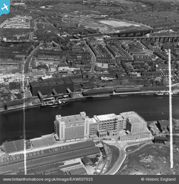
EAW037015 ENGLAND (1951). The Baltic Flour Mills, Quayside Goods Station and environs, Newcastle upon Tyne, 1951. This image has been produced from a print marked by Aerofilms Ltd for photo editing.
© Copyright OpenStreetMap contributors and licensed by the OpenStreetMap Foundation. 2026. Cartography is licensed as CC BY-SA.
Nearby Images (16)
Details
| Title | [EAW037015] The Baltic Flour Mills, Quayside Goods Station and environs, Newcastle upon Tyne, 1951. This image has been produced from a print marked by Aerofilms Ltd for photo editing. |
| Reference | EAW037015 |
| Date | 6-June-1951 |
| Link | |
| Place name | NEWCASTLE UPON TYNE |
| Parish | |
| District | |
| Country | ENGLAND |
| Easting / Northing | 425921, 564145 |
| Longitude / Latitude | -1.5950350961631, 54.971172291493 |
| National Grid Reference | NZ259641 |
Pins

RupertHughes |
Friday 19th of March 2021 01:36:02 PM | |

RupertHughes |
Wednesday 24th of February 2021 02:13:56 PM | |

MB |
Sunday 4th of September 2016 10:12:58 AM |


![[EAW037015] The Baltic Flour Mills, Quayside Goods Station and environs, Newcastle upon Tyne, 1951. This image has been produced from a print marked by Aerofilms Ltd for photo editing.](http://britainfromabove.org.uk/sites/all/libraries/aerofilms-images/public/100x100/EAW/037/EAW037015.jpg)
![[EPW048818] Quayside Goods Station, the River Tyne and environs, Newcastle Upon Tyne, from the west, 1935](http://britainfromabove.org.uk/sites/all/libraries/aerofilms-images/public/100x100/EPW/048/EPW048818.jpg)
![[EAW037014] The Baltic Flour Mills, Gateshead, 1951. This image has been produced from a print marked by Aerofilms Ltd for photo editing.](http://britainfromabove.org.uk/sites/all/libraries/aerofilms-images/public/100x100/EAW/037/EAW037014.jpg)
![[EAW037016] The Baltic Flour Mills and Quayside Goods Station, Gateshead, 1951. This image has been produced from a print marked by Aerofilms Ltd for photo editing.](http://britainfromabove.org.uk/sites/all/libraries/aerofilms-images/public/100x100/EAW/037/EAW037016.jpg)
![[EAW037011] The Baltic Flour Mills, Gateshead, 1951. This image has been produced from a print marked by Aerofilms Ltd for photo editing.](http://britainfromabove.org.uk/sites/all/libraries/aerofilms-images/public/100x100/EAW/037/EAW037011.jpg)
![[EAW037009] The Baltic Flour Mills, Gateshead, 1951. This image has been produced from a print marked by Aerofilms Ltd for photo editing.](http://britainfromabove.org.uk/sites/all/libraries/aerofilms-images/public/100x100/EAW/037/EAW037009.jpg)
![[EAW037010] The Baltic Flour Mills, Gateshead, 1951. This image has been produced from a print marked by Aerofilms Ltd for photo editing.](http://britainfromabove.org.uk/sites/all/libraries/aerofilms-images/public/100x100/EAW/037/EAW037010.jpg)
![[EAW037013] The Baltic Flour Mills, Gateshead, 1951. This image has been produced from a print marked by Aerofilms Ltd for photo editing.](http://britainfromabove.org.uk/sites/all/libraries/aerofilms-images/public/100x100/EAW/037/EAW037013.jpg)
![[EAW037018] The Baltic Flour Mills, Gateshead, 1951. This image has been produced from a print marked by Aerofilms Ltd for photo editing.](http://britainfromabove.org.uk/sites/all/libraries/aerofilms-images/public/100x100/EAW/037/EAW037018.jpg)
![[EAW037017] The Baltic Flour Mills, Gateshead, 1951. This image has been produced from a print.](http://britainfromabove.org.uk/sites/all/libraries/aerofilms-images/public/100x100/EAW/037/EAW037017.jpg)
![[EAW037008] The Baltic Flour Mills and British Ropes Ltd Rope Works, Gateshead, 1951. This image has been produced from a print marked by Aerofilms Ltd for photo editing.](http://britainfromabove.org.uk/sites/all/libraries/aerofilms-images/public/100x100/EAW/037/EAW037008.jpg)
![[EAW037012] The Baltic Flour Mills and British Ropes Ltd Rope Works, Gateshead, 1951. This image has been produced from a print marked by Aerofilms Ltd for photo editing.](http://britainfromabove.org.uk/sites/all/libraries/aerofilms-images/public/100x100/EAW/037/EAW037012.jpg)
![[EPW048233] Salt Meadows and the Quayside alongside the River Tyne, Gateshead, 1935. This image has been produced from a damaged negative.](http://britainfromabove.org.uk/sites/all/libraries/aerofilms-images/public/100x100/EPW/048/EPW048233.jpg)
![[EPW048232] Salt Meadows and environs alongside the River Tyne, Gateshead, 1935](http://britainfromabove.org.uk/sites/all/libraries/aerofilms-images/public/100x100/EPW/048/EPW048232.jpg)
![[EPW048819] Salt Meadows, the River Tyne, the site of the City Stadium and environs, Newcastle Upon Tyne, from the south-east, 1935](http://britainfromabove.org.uk/sites/all/libraries/aerofilms-images/public/100x100/EPW/048/EPW048819.jpg)
![[EPW051085] The British Ropes Ltd Wire Works, Gateshead, 1936](http://britainfromabove.org.uk/sites/all/libraries/aerofilms-images/public/100x100/EPW/051/EPW051085.jpg)