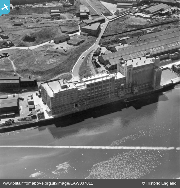
EAW037011 ENGLAND (1951). The Baltic Flour Mills, Gateshead, 1951. This image has been produced from a print marked by Aerofilms Ltd for photo editing.
© Copyright OpenStreetMap contributors and licensed by the OpenStreetMap Foundation. 2026. Cartography is licensed as CC BY-SA.
Nearby Images (19)
Details
| Title | [EAW037011] The Baltic Flour Mills, Gateshead, 1951. This image has been produced from a print marked by Aerofilms Ltd for photo editing. |
| Reference | EAW037011 |
| Date | 6-June-1951 |
| Link | |
| Place name | GATESHEAD |
| Parish | |
| District | |
| Country | ENGLAND |
| Easting / Northing | 425927, 563959 |
| Longitude / Latitude | -1.5949581817515, 54.969500390222 |
| National Grid Reference | NZ259640 |
Pins
Be the first to add a comment to this image!


![[EAW037011] The Baltic Flour Mills, Gateshead, 1951. This image has been produced from a print marked by Aerofilms Ltd for photo editing.](http://britainfromabove.org.uk/sites/all/libraries/aerofilms-images/public/100x100/EAW/037/EAW037011.jpg)
![[EAW037010] The Baltic Flour Mills, Gateshead, 1951. This image has been produced from a print marked by Aerofilms Ltd for photo editing.](http://britainfromabove.org.uk/sites/all/libraries/aerofilms-images/public/100x100/EAW/037/EAW037010.jpg)
![[EAW037009] The Baltic Flour Mills, Gateshead, 1951. This image has been produced from a print marked by Aerofilms Ltd for photo editing.](http://britainfromabove.org.uk/sites/all/libraries/aerofilms-images/public/100x100/EAW/037/EAW037009.jpg)
![[EAW037013] The Baltic Flour Mills, Gateshead, 1951. This image has been produced from a print marked by Aerofilms Ltd for photo editing.](http://britainfromabove.org.uk/sites/all/libraries/aerofilms-images/public/100x100/EAW/037/EAW037013.jpg)
![[EAW037018] The Baltic Flour Mills, Gateshead, 1951. This image has been produced from a print marked by Aerofilms Ltd for photo editing.](http://britainfromabove.org.uk/sites/all/libraries/aerofilms-images/public/100x100/EAW/037/EAW037018.jpg)
![[EAW037017] The Baltic Flour Mills, Gateshead, 1951. This image has been produced from a print.](http://britainfromabove.org.uk/sites/all/libraries/aerofilms-images/public/100x100/EAW/037/EAW037017.jpg)
![[EPW048232] Salt Meadows and environs alongside the River Tyne, Gateshead, 1935](http://britainfromabove.org.uk/sites/all/libraries/aerofilms-images/public/100x100/EPW/048/EPW048232.jpg)
![[EAW037012] The Baltic Flour Mills and British Ropes Ltd Rope Works, Gateshead, 1951. This image has been produced from a print marked by Aerofilms Ltd for photo editing.](http://britainfromabove.org.uk/sites/all/libraries/aerofilms-images/public/100x100/EAW/037/EAW037012.jpg)
![[EAW037016] The Baltic Flour Mills and Quayside Goods Station, Gateshead, 1951. This image has been produced from a print marked by Aerofilms Ltd for photo editing.](http://britainfromabove.org.uk/sites/all/libraries/aerofilms-images/public/100x100/EAW/037/EAW037016.jpg)
![[EAW037008] The Baltic Flour Mills and British Ropes Ltd Rope Works, Gateshead, 1951. This image has been produced from a print marked by Aerofilms Ltd for photo editing.](http://britainfromabove.org.uk/sites/all/libraries/aerofilms-images/public/100x100/EAW/037/EAW037008.jpg)
![[EAW037014] The Baltic Flour Mills, Gateshead, 1951. This image has been produced from a print marked by Aerofilms Ltd for photo editing.](http://britainfromabove.org.uk/sites/all/libraries/aerofilms-images/public/100x100/EAW/037/EAW037014.jpg)
![[EPW048233] Salt Meadows and the Quayside alongside the River Tyne, Gateshead, 1935. This image has been produced from a damaged negative.](http://britainfromabove.org.uk/sites/all/libraries/aerofilms-images/public/100x100/EPW/048/EPW048233.jpg)
![[EPW048818] Quayside Goods Station, the River Tyne and environs, Newcastle Upon Tyne, from the west, 1935](http://britainfromabove.org.uk/sites/all/libraries/aerofilms-images/public/100x100/EPW/048/EPW048818.jpg)
![[EAW037015] The Baltic Flour Mills, Quayside Goods Station and environs, Newcastle upon Tyne, 1951. This image has been produced from a print marked by Aerofilms Ltd for photo editing.](http://britainfromabove.org.uk/sites/all/libraries/aerofilms-images/public/100x100/EAW/037/EAW037015.jpg)
![[EPW051084] The British Ropes Ltd Wire Works, Gateshead, 1936](http://britainfromabove.org.uk/sites/all/libraries/aerofilms-images/public/100x100/EPW/051/EPW051084.jpg)
![[EPW051085] The British Ropes Ltd Wire Works, Gateshead, 1936](http://britainfromabove.org.uk/sites/all/libraries/aerofilms-images/public/100x100/EPW/051/EPW051085.jpg)
![[EPW051087] The British Ropes Ltd Wire Works, Gateshead, 1936](http://britainfromabove.org.uk/sites/all/libraries/aerofilms-images/public/100x100/EPW/051/EPW051087.jpg)
![[EPW051089] The British Ropes Ltd Wire Works, Gateshead, 1936](http://britainfromabove.org.uk/sites/all/libraries/aerofilms-images/public/100x100/EPW/051/EPW051089.jpg)
![[EPW048819] Salt Meadows, the River Tyne, the site of the City Stadium and environs, Newcastle Upon Tyne, from the south-east, 1935](http://britainfromabove.org.uk/sites/all/libraries/aerofilms-images/public/100x100/EPW/048/EPW048819.jpg)