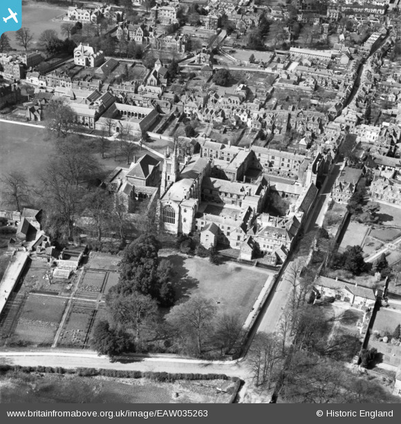
EAW035263 ENGLAND (1951). St Mary's College (Winchester College), Winchester, 1951
© Copyright OpenStreetMap contributors and licensed by the OpenStreetMap Foundation. 2026. Cartography is licensed as CC BY-SA.
Nearby Images (20)
Details
| Title | [EAW035263] St Mary's College (Winchester College), Winchester, 1951 |
| Reference | EAW035263 |
| Date | 6-April-1951 |
| Link | |
| Place name | WINCHESTER |
| Parish | |
| District | |
| Country | ENGLAND |
| Easting / Northing | 448244, 128953 |
| Longitude / Latitude | -1.3115472647951, 51.057354497093 |
| National Grid Reference | SU482290 |
Pins
Be the first to add a comment to this image!


![[EAW035263] St Mary's College (Winchester College), Winchester, 1951](http://britainfromabove.org.uk/sites/all/libraries/aerofilms-images/public/100x100/EAW/035/EAW035263.jpg)
![[EPW023319] St Mary's College, Winchester, 1928](http://britainfromabove.org.uk/sites/all/libraries/aerofilms-images/public/100x100/EPW/023/EPW023319.jpg)
![[EAW035269] St Mary's College (Winchester College), Winchester, 1951](http://britainfromabove.org.uk/sites/all/libraries/aerofilms-images/public/100x100/EAW/035/EAW035269.jpg)
![[EAW035270] St Mary's College (Winchester College), Winchester, 1951](http://britainfromabove.org.uk/sites/all/libraries/aerofilms-images/public/100x100/EAW/035/EAW035270.jpg)
![[EPW044869] St Mary's College, Winchester, 1934](http://britainfromabove.org.uk/sites/all/libraries/aerofilms-images/public/100x100/EPW/044/EPW044869.jpg)
![[EAW035268] St Mary's College (Winchester College), Winchester, 1951](http://britainfromabove.org.uk/sites/all/libraries/aerofilms-images/public/100x100/EAW/035/EAW035268.jpg)
![[EPW023322] St Mary's College and environs, Winchester, 1928](http://britainfromabove.org.uk/sites/all/libraries/aerofilms-images/public/100x100/EPW/023/EPW023322.jpg)
![[EPW044867] The Cathedral Church of the Holy Trinity, Ridding Meads and the city, Winchester, 1934](http://britainfromabove.org.uk/sites/all/libraries/aerofilms-images/public/100x100/EPW/044/EPW044867.jpg)
![[EAW035266] St Mary's College (Winchester College), the Cathedral of the Holy Trinity and the city, Winchester, 1951](http://britainfromabove.org.uk/sites/all/libraries/aerofilms-images/public/100x100/EAW/035/EAW035266.jpg)
![[EAW035267] Wolvesey Palace, the Cathedral of the Holy Trinity and the city, Winchester, 1951](http://britainfromabove.org.uk/sites/all/libraries/aerofilms-images/public/100x100/EAW/035/EAW035267.jpg)
![[EAW035264] Kingsgate Street, the Cathedral of the Holy Trinity and the city, Winchester, 1951](http://britainfromabove.org.uk/sites/all/libraries/aerofilms-images/public/100x100/EAW/035/EAW035264.jpg)
![[EAW022311] The city, Winchester, from the south-west, 1949](http://britainfromabove.org.uk/sites/all/libraries/aerofilms-images/public/100x100/EAW/022/EAW022311.jpg)
![[EAW035260] Wolvesey Palace and the Cathedral of the Holy Trinity, Winchester, 1951](http://britainfromabove.org.uk/sites/all/libraries/aerofilms-images/public/100x100/EAW/035/EAW035260.jpg)
![[EAW035265] Kingsgate Street and St Mary's College (Winchester College), Winchester, 1951](http://britainfromabove.org.uk/sites/all/libraries/aerofilms-images/public/100x100/EAW/035/EAW035265.jpg)
![[EAW035262] Wolvesey Palace, Winchester, 1951](http://britainfromabove.org.uk/sites/all/libraries/aerofilms-images/public/100x100/EAW/035/EAW035262.jpg)
![[EAW035261] Wolvesey Palace, Winchester, 1951](http://britainfromabove.org.uk/sites/all/libraries/aerofilms-images/public/100x100/EAW/035/EAW035261.jpg)
![[EPW005114A] General view of the city centre, Winchester, 1920](http://britainfromabove.org.uk/sites/all/libraries/aerofilms-images/public/100x100/EPW/005/EPW005114A.jpg)
![[EPW023326] Wolvesey Palace and environs, Winchester, 1928](http://britainfromabove.org.uk/sites/all/libraries/aerofilms-images/public/100x100/EPW/023/EPW023326.jpg)
![[EPW016868] The Cathedral of the Holy Trinity and environs, Winchester, from the south-east, 1926](http://britainfromabove.org.uk/sites/all/libraries/aerofilms-images/public/100x100/EPW/016/EPW016868.jpg)
![[EAW051300] Wolvesey Castle and the surrounding city, Winchester, 1953](http://britainfromabove.org.uk/sites/all/libraries/aerofilms-images/public/100x100/EAW/051/EAW051300.jpg)