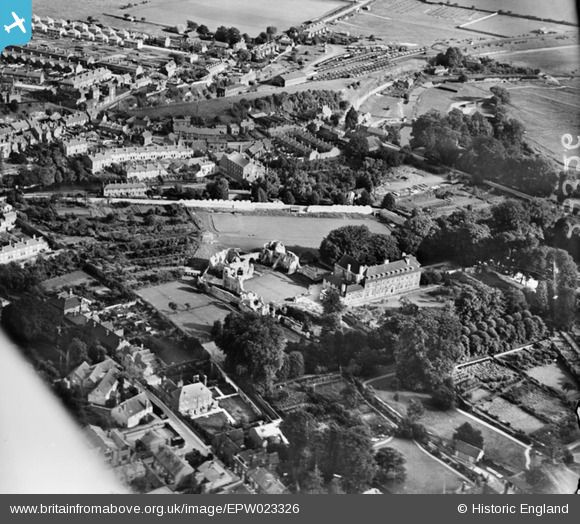
EPW023326 ENGLAND (1928). Wolvesey Palace and environs, Winchester, 1928
© Copyright OpenStreetMap contributors and licensed by the OpenStreetMap Foundation. 2026. Cartography is licensed as CC BY-SA.
Nearby Images (21)
Details
| Title | [EPW023326] Wolvesey Palace and environs, Winchester, 1928 |
| Reference | EPW023326 |
| Date | September-1928 |
| Link | |
| Place name | WINCHESTER |
| Parish | |
| District | |
| Country | ENGLAND |
| Easting / Northing | 448464, 129050 |
| Longitude / Latitude | -1.3083950644311, 51.058208240755 |
| National Grid Reference | SU485291 |
Pins
Be the first to add a comment to this image!
User Comment Contributions

Peanut |
Friday 29th of June 2012 09:12:04 AM |


![[EPW023326] Wolvesey Palace and environs, Winchester, 1928](http://britainfromabove.org.uk/sites/all/libraries/aerofilms-images/public/100x100/EPW/023/EPW023326.jpg)
![[EAW035260] Wolvesey Palace and the Cathedral of the Holy Trinity, Winchester, 1951](http://britainfromabove.org.uk/sites/all/libraries/aerofilms-images/public/100x100/EAW/035/EAW035260.jpg)
![[EAW035261] Wolvesey Palace, Winchester, 1951](http://britainfromabove.org.uk/sites/all/libraries/aerofilms-images/public/100x100/EAW/035/EAW035261.jpg)
![[EAW035262] Wolvesey Palace, Winchester, 1951](http://britainfromabove.org.uk/sites/all/libraries/aerofilms-images/public/100x100/EAW/035/EAW035262.jpg)
![[EAW035267] Wolvesey Palace, the Cathedral of the Holy Trinity and the city, Winchester, 1951](http://britainfromabove.org.uk/sites/all/libraries/aerofilms-images/public/100x100/EAW/035/EAW035267.jpg)
![[EAW051300] Wolvesey Castle and the surrounding city, Winchester, 1953](http://britainfromabove.org.uk/sites/all/libraries/aerofilms-images/public/100x100/EAW/051/EAW051300.jpg)
![[EPW044869] St Mary's College, Winchester, 1934](http://britainfromabove.org.uk/sites/all/libraries/aerofilms-images/public/100x100/EPW/044/EPW044869.jpg)
![[EAW035268] St Mary's College (Winchester College), Winchester, 1951](http://britainfromabove.org.uk/sites/all/libraries/aerofilms-images/public/100x100/EAW/035/EAW035268.jpg)
![[EPW023322] St Mary's College and environs, Winchester, 1928](http://britainfromabove.org.uk/sites/all/libraries/aerofilms-images/public/100x100/EPW/023/EPW023322.jpg)
![[EAW035263] St Mary's College (Winchester College), Winchester, 1951](http://britainfromabove.org.uk/sites/all/libraries/aerofilms-images/public/100x100/EAW/035/EAW035263.jpg)
![[EAW035270] St Mary's College (Winchester College), Winchester, 1951](http://britainfromabove.org.uk/sites/all/libraries/aerofilms-images/public/100x100/EAW/035/EAW035270.jpg)
![[EPW023319] St Mary's College, Winchester, 1928](http://britainfromabove.org.uk/sites/all/libraries/aerofilms-images/public/100x100/EPW/023/EPW023319.jpg)
![[EAW035269] St Mary's College (Winchester College), Winchester, 1951](http://britainfromabove.org.uk/sites/all/libraries/aerofilms-images/public/100x100/EAW/035/EAW035269.jpg)
![[EAW008848] The city, Winchester, from the south-east, 1947](http://britainfromabove.org.uk/sites/all/libraries/aerofilms-images/public/100x100/EAW/008/EAW008848.jpg)
![[EPW044867] The Cathedral Church of the Holy Trinity, Ridding Meads and the city, Winchester, 1934](http://britainfromabove.org.uk/sites/all/libraries/aerofilms-images/public/100x100/EPW/044/EPW044867.jpg)
![[EAW008847] The Cathedral of the Holy Trinity and the city, Winchester, 1947](http://britainfromabove.org.uk/sites/all/libraries/aerofilms-images/public/100x100/EAW/008/EAW008847.jpg)
![[EPW023325] The Cathedral of the Holy Trinity, Winchester, 1928](http://britainfromabove.org.uk/sites/all/libraries/aerofilms-images/public/100x100/EPW/023/EPW023325.jpg)
![[EAW035272] Winchester Cathedral, Winchester, 1951. This image has been produced from a print.](http://britainfromabove.org.uk/sites/all/libraries/aerofilms-images/public/100x100/EAW/035/EAW035272.jpg)
![[EPW044868] The Cathedral Church of the Holy Trinity, Winchester Barracks and the city, Winchester, from the north-east, 1934](http://britainfromabove.org.uk/sites/all/libraries/aerofilms-images/public/100x100/EPW/044/EPW044868.jpg)
![[EAW035274] Winchester Cathedral, Winchester, 1951. This image has been produced from a print.](http://britainfromabove.org.uk/sites/all/libraries/aerofilms-images/public/100x100/EAW/035/EAW035274.jpg)
![[EAW035273] Winchester Cathedral, Winchester, 1951. This image has been produced from a print.](http://britainfromabove.org.uk/sites/all/libraries/aerofilms-images/public/100x100/EAW/035/EAW035273.jpg)
