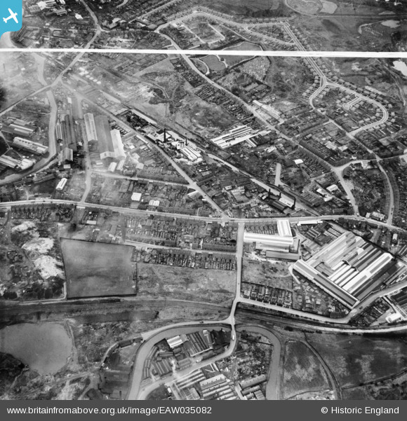
EAW035082 ENGLAND (1951). Great Bridge Street and environs, Tipton, 1951. This image was marked by Aerofilms Ltd for photo editing.
© Copyright OpenStreetMap contributors and licensed by the OpenStreetMap Foundation. 2025. Cartography is licensed as CC BY-SA.
Nearby Images (16)
Details
| Title | [EAW035082] Great Bridge Street and environs, Tipton, 1951. This image was marked by Aerofilms Ltd for photo editing. |
| Reference | EAW035082 |
| Date | 21-March-1951 |
| Link | |
| Place name | TIPTON |
| Parish | |
| District | |
| Country | ENGLAND |
| Easting / Northing | 398275, 292300 |
| Longitude / Latitude | -2.025430065341, 52.528204767919 |
| National Grid Reference | SO983923 |
Pins

DaveT |
Friday 25th of July 2025 01:05:41 PM | |

Cyril Squid |
Monday 12th of May 2025 07:19:03 PM | |

Cyril Squid |
Monday 12th of May 2025 07:18:18 PM | |

Cyril Squid |
Monday 12th of May 2025 07:17:31 PM | |

Cyril Squid |
Monday 12th of May 2025 07:17:09 PM | |

Cyril Squid |
Monday 12th of May 2025 07:16:43 PM | |

Cyril Squid |
Monday 12th of May 2025 07:16:19 PM | |

Bart |
Sunday 12th of September 2021 01:27:01 PM | |

Bart |
Sunday 12th of September 2021 01:26:36 PM | |

DaveT |
Thursday 23rd of April 2015 04:05:16 PM | |

DaveT |
Sunday 19th of April 2015 12:16:17 PM | |

Griff |
Wednesday 26th of November 2014 05:36:01 PM | |

DaveT |
Monday 28th of April 2014 04:14:01 PM | |

DaveT |
Sunday 27th of April 2014 04:21:49 PM |


![[EAW035082] Great Bridge Street and environs, Tipton, 1951. This image was marked by Aerofilms Ltd for photo editing.](http://britainfromabove.org.uk/sites/all/libraries/aerofilms-images/public/100x100/EAW/035/EAW035082.jpg)
![[EAW035081] Great Bridge Street and environs, Tipton, 1951. This image was marked by Aerofilms Ltd for photo editing.](http://britainfromabove.org.uk/sites/all/libraries/aerofilms-images/public/100x100/EAW/035/EAW035081.jpg)
![[EAW035090] Great Bridge Street and environs, Tipton, 1951](http://britainfromabove.org.uk/sites/all/libraries/aerofilms-images/public/100x100/EAW/035/EAW035090.jpg)
![[EAW035083] Great Bridge Street and environs, Tipton, 1951. This image was marked by Aerofilms Ltd for photo editing.](http://britainfromabove.org.uk/sites/all/libraries/aerofilms-images/public/100x100/EAW/035/EAW035083.jpg)
![[EAW035084] Great Bridge Street and environs, Tipton, 1951. This image was marked by Aerofilms Ltd for photo editing.](http://britainfromabove.org.uk/sites/all/libraries/aerofilms-images/public/100x100/EAW/035/EAW035084.jpg)
![[EAW035088] Wellington Tube Works, Tipton, 1951](http://britainfromabove.org.uk/sites/all/libraries/aerofilms-images/public/100x100/EAW/035/EAW035088.jpg)
![[EAW035089] Great Bridge Street and environs, Tipton, 1951](http://britainfromabove.org.uk/sites/all/libraries/aerofilms-images/public/100x100/EAW/035/EAW035089.jpg)
![[EAW035086] Wellington Tube Works, Tipton, 1951](http://britainfromabove.org.uk/sites/all/libraries/aerofilms-images/public/100x100/EAW/035/EAW035086.jpg)
![[EAW035091] Great Bridge Street and environs, Tipton, 1951](http://britainfromabove.org.uk/sites/all/libraries/aerofilms-images/public/100x100/EAW/035/EAW035091.jpg)
![[EAW035085] Great Bridge Street and environs, Tipton, 1951. This image was marked by Aerofilms Ltd for photo editing.](http://britainfromabove.org.uk/sites/all/libraries/aerofilms-images/public/100x100/EAW/035/EAW035085.jpg)
![[EAW035092] Great Bridge Street and environs, Tipton, 1951](http://britainfromabove.org.uk/sites/all/libraries/aerofilms-images/public/100x100/EAW/035/EAW035092.jpg)
![[EAW035077] Wellington Tube Works, Tipton, 1951. This image was marked by Aerofilms Ltd for photo editing.](http://britainfromabove.org.uk/sites/all/libraries/aerofilms-images/public/100x100/EAW/035/EAW035077.jpg)
![[EAW035078] Wellington Tube Works, Tipton, 1951. This image was marked by Aerofilms Ltd for photo editing.](http://britainfromabove.org.uk/sites/all/libraries/aerofilms-images/public/100x100/EAW/035/EAW035078.jpg)
![[EAW035076] Wellington Tube Works, Tipton, 1951. This image was marked by Aerofilms Ltd for photo editing.](http://britainfromabove.org.uk/sites/all/libraries/aerofilms-images/public/100x100/EAW/035/EAW035076.jpg)
![[EAW035080] Wellington Tube Works, Tipton, 1951. This image was marked by Aerofilms Ltd for photo editing.](http://britainfromabove.org.uk/sites/all/libraries/aerofilms-images/public/100x100/EAW/035/EAW035080.jpg)
![[EAW035079] Wellington Tube Works, Tipton, 1951. This image was marked by Aerofilms Ltd for photo editing.](http://britainfromabove.org.uk/sites/all/libraries/aerofilms-images/public/100x100/EAW/035/EAW035079.jpg)