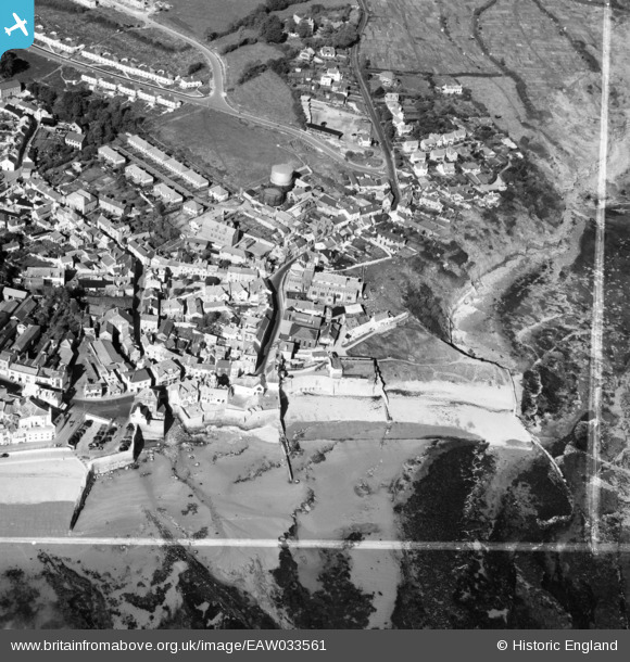
EAW033561 ENGLAND (1950). St Michael's Church, Church Street, Cobb Gate and environs, Lyme Regis, 1950. This image was marked by Aerofilms Ltd for photo editing.
© Copyright OpenStreetMap contributors and licensed by the OpenStreetMap Foundation. 2026. Cartography is licensed as CC BY-SA.
Nearby Images (21)
Details
| Title | [EAW033561] St Michael's Church, Church Street, Cobb Gate and environs, Lyme Regis, 1950. This image was marked by Aerofilms Ltd for photo editing. |
| Reference | EAW033561 |
| Date | 12-October-1950 |
| Link | |
| Place name | LYME REGIS |
| Parish | LYME REGIS |
| District | |
| Country | ENGLAND |
| Easting / Northing | 334327, 92177 |
| Longitude / Latitude | -2.9305247180831, 50.724926157072 |
| National Grid Reference | SY343922 |
Pins

Matt Aldred edob.mattaldred.com |
Tuesday 9th of March 2021 09:04:44 AM | |

Alan McFaden |
Monday 21st of July 2014 10:32:01 AM | |

Alan McFaden |
Monday 21st of July 2014 10:31:04 AM | |

Alan McFaden |
Monday 21st of July 2014 10:30:37 AM | |

Alan McFaden |
Monday 21st of July 2014 10:29:56 AM | |

Al |
Sunday 8th of June 2014 10:41:50 AM | |

cptpies |
Tuesday 20th of May 2014 12:18:01 PM | |
Not a pillbox. 57mm (6 pdr) mounting, using old guns from WW1 tanks. Ground level photo shows correct number of bolts on the holdfast ring. |

M328 |
Monday 15th of April 2024 10:54:13 PM |
User Comment Contributions

cptpies |
Tuesday 20th of May 2014 12:19:19 PM |


![[EAW033561] St Michael's Church, Church Street, Cobb Gate and environs, Lyme Regis, 1950. This image was marked by Aerofilms Ltd for photo editing.](http://britainfromabove.org.uk/sites/all/libraries/aerofilms-images/public/100x100/EAW/033/EAW033561.jpg)
![[EAW033564] St Michael's Church, the seafront and town, Lyme Regis, 1950. This image was marked by Aerofilms Ltd for photo editing.](http://britainfromabove.org.uk/sites/all/libraries/aerofilms-images/public/100x100/EAW/033/EAW033564.jpg)
![[EAW033566] St Michael's Church, the seafront and town, Lyme Regis, 1950. This image was marked by Aerofilms Ltd for photo editing.](http://britainfromabove.org.uk/sites/all/libraries/aerofilms-images/public/100x100/EAW/033/EAW033566.jpg)
![[EAW033663] St Michael's Church, Lyme Regis, 1950](http://britainfromabove.org.uk/sites/all/libraries/aerofilms-images/public/100x100/EAW/033/EAW033663.jpg)
![[EAW033559] St Michael's Church, Church Street, the Gables Hotel and environs, Lyme Regis, 1950. This image was marked by Aerofilms Ltd for photo editing.](http://britainfromabove.org.uk/sites/all/libraries/aerofilms-images/public/100x100/EAW/033/EAW033559.jpg)
![[EAW033560] St Michael's Church, Church Street and environs, Lyme Regis, 1950. This image was marked by Aerofilms Ltd for photo editing.](http://britainfromabove.org.uk/sites/all/libraries/aerofilms-images/public/100x100/EAW/033/EAW033560.jpg)
![[EAW033565] St Michael's Church and the Gables Hotel looking towards Anning Road, Lyme Regis, 1950. This image was marked by Aerofilms Ltd for photo editing.](http://britainfromabove.org.uk/sites/all/libraries/aerofilms-images/public/100x100/EAW/033/EAW033565.jpg)
![[EAW033562] Church Street and environs looking towards Anning Road, Lyme Regis, 1950](http://britainfromabove.org.uk/sites/all/libraries/aerofilms-images/public/100x100/EAW/033/EAW033562.jpg)
![[EPW013475] The seafront and town, Lyme Regis, 1925. This image has been produced from a print.](http://britainfromabove.org.uk/sites/all/libraries/aerofilms-images/public/100x100/EPW/013/EPW013475.jpg)
![[EPW013474] The seafront, Lyme Regis, 1925. This image has been produced from a print.](http://britainfromabove.org.uk/sites/all/libraries/aerofilms-images/public/100x100/EPW/013/EPW013474.jpg)
![[EAW033563] Church Street and environs looking towards Anning Road, Lyme Regis, 1950. This image was marked by Aerofilms Ltd for photo editing.](http://britainfromabove.org.uk/sites/all/libraries/aerofilms-images/public/100x100/EAW/033/EAW033563.jpg)
![[EPW023892] St Michael's Church and the town, Lyme Regis, 1928](http://britainfromabove.org.uk/sites/all/libraries/aerofilms-images/public/100x100/EPW/023/EPW023892.jpg)
![[EAW033662] Church Street, Lyme Regis, 1950](http://britainfromabove.org.uk/sites/all/libraries/aerofilms-images/public/100x100/EAW/033/EAW033662.jpg)
![[EPW013478] Cobb Gate and the town, Lyme Regis, 1925. This image has been produced from a print.](http://britainfromabove.org.uk/sites/all/libraries/aerofilms-images/public/100x100/EPW/013/EPW013478.jpg)
![[EPW039713] The seafront from Long Ledge to Lucy's Ledge and the town, Lyme Regis, 1932](http://britainfromabove.org.uk/sites/all/libraries/aerofilms-images/public/100x100/EPW/039/EPW039713.jpg)
![[EPW023896] The seafront and the town, Lyme Regis, from the south-east, 1928](http://britainfromabove.org.uk/sites/all/libraries/aerofilms-images/public/100x100/EPW/023/EPW023896.jpg)
![[EPW024181] Broad Street and the waterfront, Lyme Regis, 1928](http://britainfromabove.org.uk/sites/all/libraries/aerofilms-images/public/100x100/EPW/024/EPW024181.jpg)
![[EAW050063] The town and harbour, Lyme Regis, from the north-east, 1953](http://britainfromabove.org.uk/sites/all/libraries/aerofilms-images/public/100x100/EAW/050/EAW050063.jpg)
![[EPW039715] The seafront and the town, Lyme Regis, 1932](http://britainfromabove.org.uk/sites/all/libraries/aerofilms-images/public/100x100/EPW/039/EPW039715.jpg)
![[EPW024179] Church Cliffs and the town, Lyme Regis, from the south-east, 1928](http://britainfromabove.org.uk/sites/all/libraries/aerofilms-images/public/100x100/EPW/024/EPW024179.jpg)
![[EAW050064] The town, Lyme Regis, 1953](http://britainfromabove.org.uk/sites/all/libraries/aerofilms-images/public/100x100/EAW/050/EAW050064.jpg)


