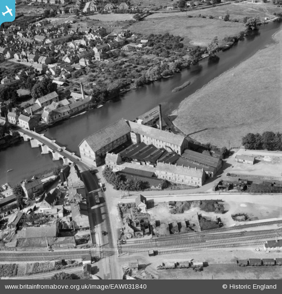
EAW031840 ENGLAND (1950). Huntingdon Hosiery Mill, Godmanchester, 1950
© Copyright OpenStreetMap contributors and licensed by the OpenStreetMap Foundation. 2026. Cartography is licensed as CC BY-SA.
Nearby Images (15)
Details
| Title | [EAW031840] Huntingdon Hosiery Mill, Godmanchester, 1950 |
| Reference | EAW031840 |
| Date | 14-August-1950 |
| Link | |
| Place name | GODMANCHESTER |
| Parish | GODMANCHESTER |
| District | |
| Country | ENGLAND |
| Easting / Northing | 524352, 271458 |
| Longitude / Latitude | -0.17505622261093, 52.326719702989 |
| National Grid Reference | TL244715 |
Pins

Matt Aldred edob.mattaldred.com |
Thursday 7th of March 2024 05:05:32 PM | |

Matt Aldred edob.mattaldred.com |
Sunday 8th of November 2020 08:41:46 PM | |

John Wass |
Tuesday 9th of September 2014 03:49:11 PM | |

Class31 |
Wednesday 11th of June 2014 01:30:04 PM |
User Comment Contributions
Huntingdon Hosiery Mill, Godmanchester , 10/06/2014 |

Class31 |
Wednesday 11th of June 2014 02:37:22 PM |
Huntingdon Hosiery Mill, Godmanchester , 10/06/2014 |

Class31 |
Wednesday 11th of June 2014 01:33:26 PM |
The Bridge & Mill, Godmanchester , 10/06/2014 |

Class31 |
Wednesday 11th of June 2014 01:32:23 PM |
The Bridge, Godmanchester , 10/06/2014 |

Class31 |
Wednesday 11th of June 2014 01:31:11 PM |
Huntingdon Hosiery Mill, Godmanchester , 10/06/2014 |

Class31 |
Wednesday 11th of June 2014 01:28:41 PM |


![[EAW031840] Huntingdon Hosiery Mill, Godmanchester, 1950](http://britainfromabove.org.uk/sites/all/libraries/aerofilms-images/public/100x100/EAW/031/EAW031840.jpg)
![[EAW031841] Huntingdon Hosiery Mill, Godmanchester, 1950. This image was marked by Aerofilms Ltd for photo editing.](http://britainfromabove.org.uk/sites/all/libraries/aerofilms-images/public/100x100/EAW/031/EAW031841.jpg)
![[EAW031843] Huntingdon Hosiery Mill, Godmanchester, 1950. This image was marked by Aerofilms Ltd for photo editing.](http://britainfromabove.org.uk/sites/all/libraries/aerofilms-images/public/100x100/EAW/031/EAW031843.jpg)
![[EPW014429] Huntingdon Bridge, Bridge Place and Adelaide Terrace, Godmanchester, 1925. This image has been produced from a copy-negative.](http://britainfromabove.org.uk/sites/all/libraries/aerofilms-images/public/100x100/EPW/014/EPW014429.jpg)
![[EAW031845] Huntingdon Hosiery Mill and Huntingdon Bridge, Godmanchester, 1950. This image was marked by Aerofilms Ltd for photo editing.](http://britainfromabove.org.uk/sites/all/libraries/aerofilms-images/public/100x100/EAW/031/EAW031845.jpg)
![[EAW031838] Huntingdon Hosiery Mill, Godmanchester, 1950. This image was marked by Aerofilms Ltd for photo editing.](http://britainfromabove.org.uk/sites/all/libraries/aerofilms-images/public/100x100/EAW/031/EAW031838.jpg)
![[EAW031844] Huntingdon Hosiery Mill, Godmanchester, 1950. This image was marked by Aerofilms Ltd for photo editing.](http://britainfromabove.org.uk/sites/all/libraries/aerofilms-images/public/100x100/EAW/031/EAW031844.jpg)
![[EAW031842] Huntingdon Hosiery Mill, Godmanchester, 1950. This image was marked by Aerofilms Ltd for photo editing.](http://britainfromabove.org.uk/sites/all/libraries/aerofilms-images/public/100x100/EAW/031/EAW031842.jpg)
![[EAW031839] Huntingdon Hosiery Mill, Godmanchester, 1950. This image was marked by Aerofilms Ltd for photo editing.](http://britainfromabove.org.uk/sites/all/libraries/aerofilms-images/public/100x100/EAW/031/EAW031839.jpg)
![[EAW031837] Huntingdon Hosiery Mill, Godmanchester, 1950. This image was marked by Aerofilms Ltd for photo editing.](http://britainfromabove.org.uk/sites/all/libraries/aerofilms-images/public/100x100/EAW/031/EAW031837.jpg)
![[EPW041329] The town, Huntingdon, from the south-east, 1933](http://britainfromabove.org.uk/sites/all/libraries/aerofilms-images/public/100x100/EPW/041/EPW041329.jpg)
![[EPW041330] Huntingdon Bridge and environs, Huntingdon, 1933](http://britainfromabove.org.uk/sites/all/libraries/aerofilms-images/public/100x100/EPW/041/EPW041330.jpg)
![[EAW051767] The High Street, St Mary's Church and the River Great Ouse, Huntingdon, 1953](http://britainfromabove.org.uk/sites/all/libraries/aerofilms-images/public/100x100/EAW/051/EAW051767.jpg)
![[EAW003736] Extensive flooding around Huntingdon, Godmanchester, from the south-east, 1947](http://britainfromabove.org.uk/sites/all/libraries/aerofilms-images/public/100x100/EAW/003/EAW003736.jpg)
![[EAW051769] The town, Huntingdon, 1953](http://britainfromabove.org.uk/sites/all/libraries/aerofilms-images/public/100x100/EAW/051/EAW051769.jpg)