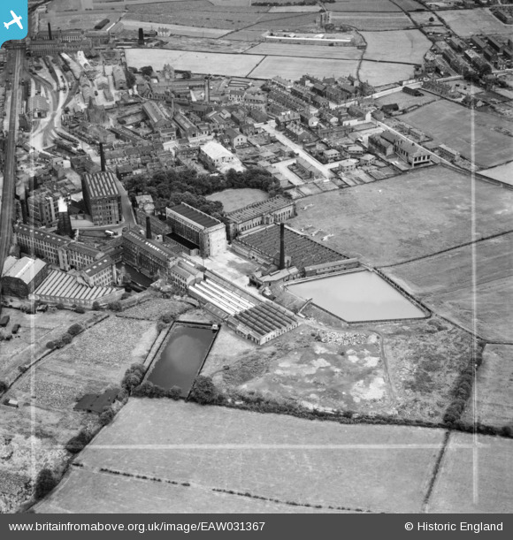
EAW031367 ENGLAND (1950). Leigh Mills and environs, Stanningley, 1950. This image was marked by Aerofilms Ltd for photo editing.
© Copyright OpenStreetMap contributors and licensed by the OpenStreetMap Foundation. 2026. Cartography is licensed as CC BY-SA.
Nearby Images (22)
Details
| Title | [EAW031367] Leigh Mills and environs, Stanningley, 1950. This image was marked by Aerofilms Ltd for photo editing. |
| Reference | EAW031367 |
| Date | 26-July-1950 |
| Link | |
| Place name | STANNINGLEY |
| Parish | |
| District | |
| Country | ENGLAND |
| Easting / Northing | 421859, 434145 |
| Longitude / Latitude | -1.6680601080499, 53.802930106836 |
| National Grid Reference | SE219341 |
Pins
Be the first to add a comment to this image!


![[EAW031367] Leigh Mills and environs, Stanningley, 1950. This image was marked by Aerofilms Ltd for photo editing.](http://britainfromabove.org.uk/sites/all/libraries/aerofilms-images/public/100x100/EAW/031/EAW031367.jpg)
![[EAW031368] Leigh Mills and environs, Stanningley, 1950. This image was marked by Aerofilms Ltd for photo editing.](http://britainfromabove.org.uk/sites/all/libraries/aerofilms-images/public/100x100/EAW/031/EAW031368.jpg)
![[EAW031366] Leigh Mills and environs, Stanningley, 1950. This image was marked by Aerofilms Ltd for photo editing.](http://britainfromabove.org.uk/sites/all/libraries/aerofilms-images/public/100x100/EAW/031/EAW031366.jpg)
![[EAW025234] The Leigh Worsted Mills and the surrounding area, Pudsey, from the east, 1949](http://britainfromabove.org.uk/sites/all/libraries/aerofilms-images/public/100x100/EAW/025/EAW025234.jpg)
![[EAW031369] Leigh Mills, Stanningley, 1950. This image was marked by Aerofilms Ltd for photo editing.](http://britainfromabove.org.uk/sites/all/libraries/aerofilms-images/public/100x100/EAW/031/EAW031369.jpg)
![[EAW031365] Leigh Mills and environs, Stanningley, 1950. This image was marked by Aerofilms Ltd for photo editing.](http://britainfromabove.org.uk/sites/all/libraries/aerofilms-images/public/100x100/EAW/031/EAW031365.jpg)
![[EAW031364] Leigh Mills, Bradford Road and environs, Stanningley, 1950. This image was marked by Aerofilms Ltd for photo editing.](http://britainfromabove.org.uk/sites/all/libraries/aerofilms-images/public/100x100/EAW/031/EAW031364.jpg)
![[EAW031362] Leigh Mills, Stanningley, 1950. This image was marked by Aerofilms Ltd for photo editing.](http://britainfromabove.org.uk/sites/all/libraries/aerofilms-images/public/100x100/EAW/031/EAW031362.jpg)
![[EPW023834] Leigh Mills, Stanningley, 1928](http://britainfromabove.org.uk/sites/all/libraries/aerofilms-images/public/100x100/EPW/023/EPW023834.jpg)
![[EAW031363] Leigh Mills, Stanningley, 1950. This image was marked by Aerofilms Ltd for photo editing.](http://britainfromabove.org.uk/sites/all/libraries/aerofilms-images/public/100x100/EAW/031/EAW031363.jpg)
![[EAW025235] The Leigh Worsted Mills, Pudsey, 1949](http://britainfromabove.org.uk/sites/all/libraries/aerofilms-images/public/100x100/EAW/025/EAW025235.jpg)
![[EAW025238] The Leigh Worsted Mills and the surrounding area, Pudsey, from the north, 1949. This image was marked by Aerofilms Ltd for photo editing.](http://britainfromabove.org.uk/sites/all/libraries/aerofilms-images/public/100x100/EAW/025/EAW025238.jpg)
![[EAW025232] The Leigh Worsted Mills, Pudsey, 1949. This image was marked by Aerofilms Ltd for photo editing.](http://britainfromabove.org.uk/sites/all/libraries/aerofilms-images/public/100x100/EAW/025/EAW025232.jpg)
![[EAW025233] The Leigh Worsted Mills and the surrounding area, Pudsey, from the north-east, 1949. This image was marked by Aerofilms Ltd for photo editing.](http://britainfromabove.org.uk/sites/all/libraries/aerofilms-images/public/100x100/EAW/025/EAW025233.jpg)
![[EAW025236] The Leigh Worsted Mills and the surrounding area, Pudsey, 1949. This image was marked by Aerofilms Ltd for photo editing.](http://britainfromabove.org.uk/sites/all/libraries/aerofilms-images/public/100x100/EAW/025/EAW025236.jpg)
![[EAW025231] The Leigh Worsted Mills, Pudsey, from the south, 1949](http://britainfromabove.org.uk/sites/all/libraries/aerofilms-images/public/100x100/EAW/025/EAW025231.jpg)
![[EPW034273] Woollen Mills around Varley Street, Stanningley, 1930](http://britainfromabove.org.uk/sites/all/libraries/aerofilms-images/public/100x100/EPW/034/EPW034273.jpg)
![[EPW028887] Leigh Mills, Stanningley, 1929](http://britainfromabove.org.uk/sites/all/libraries/aerofilms-images/public/100x100/EPW/028/EPW028887.jpg)
![[EAW025230] The Leigh Worsted Mills, Pudsey, from the south, 1949. This image was marked by Aerofilms Ltd for photo editing.](http://britainfromabove.org.uk/sites/all/libraries/aerofilms-images/public/100x100/EAW/025/EAW025230.jpg)
![[EAW025239] The Leigh Worsted Mills and the surrounding area, Pudsey, 1949. This image was marked by Aerofilms Ltd for photo editing.](http://britainfromabove.org.uk/sites/all/libraries/aerofilms-images/public/100x100/EAW/025/EAW025239.jpg)
![[EPW023836] Leigh Mills and environs, Stanningley, 1928](http://britainfromabove.org.uk/sites/all/libraries/aerofilms-images/public/100x100/EPW/023/EPW023836.jpg)
![[EPW034279] Delph Hill and the town, Pudsey, from the north, 1930](http://britainfromabove.org.uk/sites/all/libraries/aerofilms-images/public/100x100/EPW/034/EPW034279.jpg)