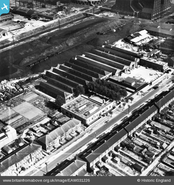
EAW031226 ENGLAND (1950). The City Engraving Co Ltd Works and environs, Kingston upon Hull, 1950. This image has been produced from a print marked by Aerofilms Ltd for photo editing.
© Copyright OpenStreetMap contributors and licensed by the OpenStreetMap Foundation. 2026. Cartography is licensed as CC BY-SA.
Nearby Images (12)
Details
| Title | [EAW031226] The City Engraving Co Ltd Works and environs, Kingston upon Hull, 1950. This image has been produced from a print marked by Aerofilms Ltd for photo editing. |
| Reference | EAW031226 |
| Date | 25-July-1950 |
| Link | |
| Place name | KINGSTON UPON HULL |
| Parish | |
| District | |
| Country | ENGLAND |
| Easting / Northing | 508988, 431294 |
| Longitude / Latitude | -0.34633493463658, 53.766356486106 |
| National Grid Reference | TA090313 |
Pins

John Wass |
Friday 21st of November 2014 08:41:16 PM |


![[EAW031226] The City Engraving Co Ltd Works and environs, Kingston upon Hull, 1950. This image has been produced from a print marked by Aerofilms Ltd for photo editing.](http://britainfromabove.org.uk/sites/all/libraries/aerofilms-images/public/100x100/EAW/031/EAW031226.jpg)
![[EAW031225] The City Engraving Co Ltd Works and environs, Kingston upon Hull, 1950. This image has been produced from a print marked by Aerofilms Ltd for photo editing.](http://britainfromabove.org.uk/sites/all/libraries/aerofilms-images/public/100x100/EAW/031/EAW031225.jpg)
![[EAW031229] The City Engraving Co Ltd Works and environs, Kingston upon Hull, 1950. This image was marked by Aerofilms Ltd for photo editing.](http://britainfromabove.org.uk/sites/all/libraries/aerofilms-images/public/100x100/EAW/031/EAW031229.jpg)
![[EAW031230] The City Engraving Co Ltd Works and environs, Kingston upon Hull, 1950. This image has been produced from a print marked by Aerofilms Ltd for photo editing.](http://britainfromabove.org.uk/sites/all/libraries/aerofilms-images/public/100x100/EAW/031/EAW031230.jpg)
![[EAW031227] The City Engraving Co Ltd Works and environs, Kingston upon Hull, 1950. This image has been produced from a print marked by Aerofilms Ltd for photo editing.](http://britainfromabove.org.uk/sites/all/libraries/aerofilms-images/public/100x100/EAW/031/EAW031227.jpg)
![[EAW031231] The City Engraving Co Ltd Works and environs, Kingston upon Hull, 1950. This image has been produced from a print marked by Aerofilms Ltd for photo editing.](http://britainfromabove.org.uk/sites/all/libraries/aerofilms-images/public/100x100/EAW/031/EAW031231.jpg)
![[EAW031228] The City Engraving Co Ltd Works and environs, Kingston upon Hull, 1950. This image has been produced from a print marked by Aerofilms Ltd for photo editing.](http://britainfromabove.org.uk/sites/all/libraries/aerofilms-images/public/100x100/EAW/031/EAW031228.jpg)
![[EAW031232] The City Engraving Co Ltd Works and environs, Kingston upon Hull, 1950. This image has been produced from a print marked by Aerofilms Ltd for photo editing.](http://britainfromabove.org.uk/sites/all/libraries/aerofilms-images/public/100x100/EAW/031/EAW031232.jpg)
![[EPW006340] Allotments and open ground to the north of the Hull Corporation Electricity Works, Sculcoates, 1921](http://britainfromabove.org.uk/sites/all/libraries/aerofilms-images/public/100x100/EPW/006/EPW006340.jpg)
![[EPW006341] Cooling towers and old clay pits beside Sculcoates Junction, Sculcoates, 1921](http://britainfromabove.org.uk/sites/all/libraries/aerofilms-images/public/100x100/EPW/006/EPW006341.jpg)
![[EPW006335] The Newland Glass Bottle Works and Kingston Pottery, Sculcoates, 1921](http://britainfromabove.org.uk/sites/all/libraries/aerofilms-images/public/100x100/EPW/006/EPW006335.jpg)
![[EPW006339] Sculcoates Junction and the Hull Corporation Electricity Works, Sculcoates, 1921](http://britainfromabove.org.uk/sites/all/libraries/aerofilms-images/public/100x100/EPW/006/EPW006339.jpg)