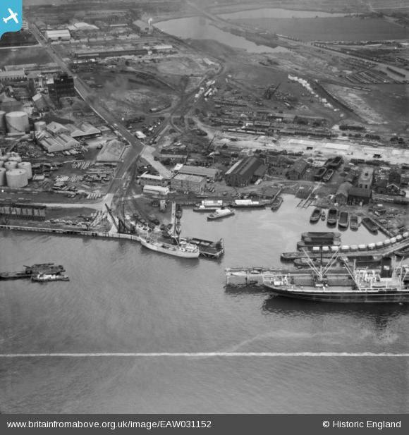
EAW031152 ENGLAND (1950). Dagenham Dock, Dagenham, 1950. This image was marked by Aerofilms Ltd for photo editing.
© Copyright OpenStreetMap contributors and licensed by the OpenStreetMap Foundation. 2026. Cartography is licensed as CC BY-SA.
Nearby Images (26)
Details
| Title | [EAW031152] Dagenham Dock, Dagenham, 1950. This image was marked by Aerofilms Ltd for photo editing. |
| Reference | EAW031152 |
| Date | 25-July-1950 |
| Link | |
| Place name | DAGENHAM |
| Parish | |
| District | |
| Country | ENGLAND |
| Easting / Northing | 548898, 181787 |
| Longitude / Latitude | 0.14612789230703, 51.514875139848 |
| National Grid Reference | TQ489818 |
Pins
Be the first to add a comment to this image!


![[EAW031152] Dagenham Dock, Dagenham, 1950. This image was marked by Aerofilms Ltd for photo editing.](http://britainfromabove.org.uk/sites/all/libraries/aerofilms-images/public/100x100/EAW/031/EAW031152.jpg)
![[EAW031157] Dagenham Dock, Dagenham, 1950](http://britainfromabove.org.uk/sites/all/libraries/aerofilms-images/public/100x100/EAW/031/EAW031157.jpg)
![[EAW031153] Dagenham Dock, Dagenham, 1950. This image was marked by Aerofilms Ltd for photo editing.](http://britainfromabove.org.uk/sites/all/libraries/aerofilms-images/public/100x100/EAW/031/EAW031153.jpg)
![[EAW031149] Dagenham Dock, Dagenham, 1950. This image was marked by Aerofilms Ltd for photo editing.](http://britainfromabove.org.uk/sites/all/libraries/aerofilms-images/public/100x100/EAW/031/EAW031149.jpg)
![[EAW031151] Dagenham Dock, Dagenham, 1950. This image was marked by Aerofilms Ltd for photo editing.](http://britainfromabove.org.uk/sites/all/libraries/aerofilms-images/public/100x100/EAW/031/EAW031151.jpg)
![[EPW009945] Dagenham Dock, Dagenham, 1924](http://britainfromabove.org.uk/sites/all/libraries/aerofilms-images/public/100x100/EPW/009/EPW009945.jpg)
![[EPW010924] Dagenham Dock, Dagenham, 1924. This image has been produced from a copy-negative.](http://britainfromabove.org.uk/sites/all/libraries/aerofilms-images/public/100x100/EPW/010/EPW010924.jpg)
![[EAW031150] Dagenham Dock, Dagenham, 1950. This image was marked by Aerofilms Ltd for photo editing.](http://britainfromabove.org.uk/sites/all/libraries/aerofilms-images/public/100x100/EAW/031/EAW031150.jpg)
![[EPW059962] The Texaco Oil Depot off Chequers Lane, Dagenham, 1938](http://britainfromabove.org.uk/sites/all/libraries/aerofilms-images/public/100x100/EPW/059/EPW059962.jpg)
![[EPW059963] The Texaco Oil Depot off Chequers Lane, Dagenham, 1938](http://britainfromabove.org.uk/sites/all/libraries/aerofilms-images/public/100x100/EPW/059/EPW059963.jpg)
![[EPW059966] The Texaco Oil Depot off Chequers Lane, Dagenham, 1938](http://britainfromabove.org.uk/sites/all/libraries/aerofilms-images/public/100x100/EPW/059/EPW059966.jpg)
![[EPW059967] The Texaco Oil Depot off Chequers Lane, Dagenham, 1938. This image has been produced from a damaged negative.](http://britainfromabove.org.uk/sites/all/libraries/aerofilms-images/public/100x100/EPW/059/EPW059967.jpg)
![[EPW009950] Dagenham Dock, Dagenham, 1924](http://britainfromabove.org.uk/sites/all/libraries/aerofilms-images/public/100x100/EPW/009/EPW009950.jpg)
![[EPW059964] The Texaco Oil Depot off Chequers Lane, Dagenham, 1938](http://britainfromabove.org.uk/sites/all/libraries/aerofilms-images/public/100x100/EPW/059/EPW059964.jpg)
![[EPW059960] The Texaco Oil Depot off Chequers Lane, Dagenham, 1938](http://britainfromabove.org.uk/sites/all/libraries/aerofilms-images/public/100x100/EPW/059/EPW059960.jpg)
![[EPW021397] The Solvent Products Works, Dagenham, 1928](http://britainfromabove.org.uk/sites/all/libraries/aerofilms-images/public/100x100/EPW/021/EPW021397.jpg)
![[EPW059961] The Texaco Oil Depot off Chequers Lane, Dagenham, 1938](http://britainfromabove.org.uk/sites/all/libraries/aerofilms-images/public/100x100/EPW/059/EPW059961.jpg)
![[EPW059965] The Texaco Oil Depot off Chequers Lane, Dagenham, 1938](http://britainfromabove.org.uk/sites/all/libraries/aerofilms-images/public/100x100/EPW/059/EPW059965.jpg)
![[EPW021398] The Solvent Products Works and works off Chequers Lane, Dagenham, 1928](http://britainfromabove.org.uk/sites/all/libraries/aerofilms-images/public/100x100/EPW/021/EPW021398.jpg)
![[EAW031154] The landing stage beside Dagenham Dock, Dagenham, 1950. This image was marked by Aerofilms Ltd for photo editing.](http://britainfromabove.org.uk/sites/all/libraries/aerofilms-images/public/100x100/EAW/031/EAW031154.jpg)
![[EPW009947] Dagenham Dock and the River Thames, Dagenham, from the north-west, 1924](http://britainfromabove.org.uk/sites/all/libraries/aerofilms-images/public/100x100/EPW/009/EPW009947.jpg)
![[EPW046551] Dagenham Docks, the Dagenham Marshes and the Solvent Products Ltd Works, Dagenham, 1935](http://britainfromabove.org.uk/sites/all/libraries/aerofilms-images/public/100x100/EPW/046/EPW046551.jpg)
![[EPW009951] Dagenham Dock and factories on Chequers Lane, Dagenham, 1924](http://britainfromabove.org.uk/sites/all/libraries/aerofilms-images/public/100x100/EPW/009/EPW009951.jpg)
![[EPW021389] The Solvent Products Works, Dagenham, 1928](http://britainfromabove.org.uk/sites/all/libraries/aerofilms-images/public/100x100/EPW/021/EPW021389.jpg)
![[EPW046546] Dagenham Dock, Dagenham Marshes and the Solvent Products Ltd Works, Dagenham, 1935](http://britainfromabove.org.uk/sites/all/libraries/aerofilms-images/public/100x100/EPW/046/EPW046546.jpg)
![[EPW046614] The Solvent Products Works and environs, Dagenham, 1935](http://britainfromabove.org.uk/sites/all/libraries/aerofilms-images/public/100x100/EPW/046/EPW046614.jpg)