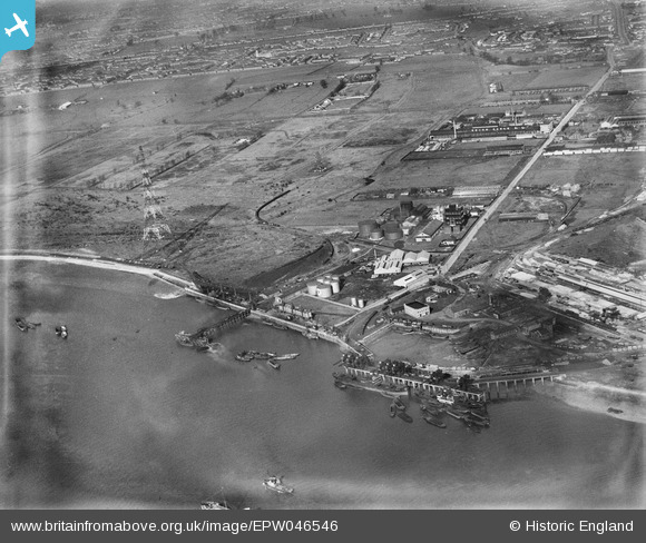
EPW046546 ENGLAND (1935). Dagenham Dock, Dagenham Marshes and the Solvent Products Ltd Works, Dagenham, 1935
© Copyright OpenStreetMap contributors and licensed by the OpenStreetMap Foundation. 2026. Cartography is licensed as CC BY-SA.
Nearby Images (48)
Details
| Title | [EPW046546] Dagenham Dock, Dagenham Marshes and the Solvent Products Ltd Works, Dagenham, 1935 |
| Reference | EPW046546 |
| Date | February-1935 |
| Link | |
| Place name | DAGENHAM |
| Parish | |
| District | |
| Country | ENGLAND |
| Easting / Northing | 548764, 182007 |
| Longitude / Latitude | 0.14429081915224, 51.51688740593 |
| National Grid Reference | TQ488820 |
Pins
Be the first to add a comment to this image!


![[EPW046546] Dagenham Dock, Dagenham Marshes and the Solvent Products Ltd Works, Dagenham, 1935](http://britainfromabove.org.uk/sites/all/libraries/aerofilms-images/public/100x100/EPW/046/EPW046546.jpg)
![[EPW009947] Dagenham Dock and the River Thames, Dagenham, from the north-west, 1924](http://britainfromabove.org.uk/sites/all/libraries/aerofilms-images/public/100x100/EPW/009/EPW009947.jpg)
![[EPW046614] The Solvent Products Works and environs, Dagenham, 1935](http://britainfromabove.org.uk/sites/all/libraries/aerofilms-images/public/100x100/EPW/046/EPW046614.jpg)
![[EPW046551] Dagenham Docks, the Dagenham Marshes and the Solvent Products Ltd Works, Dagenham, 1935](http://britainfromabove.org.uk/sites/all/libraries/aerofilms-images/public/100x100/EPW/046/EPW046551.jpg)
![[EPW021395] The Solvent Products Works, Dagenham, 1928](http://britainfromabove.org.uk/sites/all/libraries/aerofilms-images/public/100x100/EPW/021/EPW021395.jpg)
![[EPW059965] The Texaco Oil Depot off Chequers Lane, Dagenham, 1938](http://britainfromabove.org.uk/sites/all/libraries/aerofilms-images/public/100x100/EPW/059/EPW059965.jpg)
![[EAW031165] The fuel storage depot beside Dagenham Dock, Dagenham, 1950. This image was marked by Aerofilms Ltd for photo editing.](http://britainfromabove.org.uk/sites/all/libraries/aerofilms-images/public/100x100/EAW/031/EAW031165.jpg)
![[EAW031166] The fuel storage depot beside Dagenham Dock, Dagenham, 1950](http://britainfromabove.org.uk/sites/all/libraries/aerofilms-images/public/100x100/EAW/031/EAW031166.jpg)
![[EPW021398] The Solvent Products Works and works off Chequers Lane, Dagenham, 1928](http://britainfromabove.org.uk/sites/all/libraries/aerofilms-images/public/100x100/EPW/021/EPW021398.jpg)
![[EAW046775] The jetties, depots and industrial premises at Horse Shoe Corner, Dagenham, from the south-east, 1952. This image was marked by Aerofilms Ltd for photo editing.](http://britainfromabove.org.uk/sites/all/libraries/aerofilms-images/public/100x100/EAW/046/EAW046775.jpg)
![[EPW059964] The Texaco Oil Depot off Chequers Lane, Dagenham, 1938](http://britainfromabove.org.uk/sites/all/libraries/aerofilms-images/public/100x100/EPW/059/EPW059964.jpg)
![[EPW021397] The Solvent Products Works, Dagenham, 1928](http://britainfromabove.org.uk/sites/all/libraries/aerofilms-images/public/100x100/EPW/021/EPW021397.jpg)
![[EAW031159] The fuel storage depot beside Dagenham Dock, Dagenham, 1950. This image was marked by Aerofilms Ltd for photo editing.](http://britainfromabove.org.uk/sites/all/libraries/aerofilms-images/public/100x100/EAW/031/EAW031159.jpg)
![[EAW046771] The jetties, depots and industrial premises at Horse Shoe Corner, Dagenham, from the south-east, 1952. This image was marked by Aerofilms Ltd for photo editing.](http://britainfromabove.org.uk/sites/all/libraries/aerofilms-images/public/100x100/EAW/046/EAW046771.jpg)
![[EAW031163] The fuel storage depot beside Dagenham Dock, Dagenham, 1950. This image was marked by Aerofilms Ltd for photo editing.](http://britainfromabove.org.uk/sites/all/libraries/aerofilms-images/public/100x100/EAW/031/EAW031163.jpg)
![[EPW021391] The Solvent Products Works, Dagenham, 1928](http://britainfromabove.org.uk/sites/all/libraries/aerofilms-images/public/100x100/EPW/021/EPW021391.jpg)
![[EPW021389] The Solvent Products Works, Dagenham, 1928](http://britainfromabove.org.uk/sites/all/libraries/aerofilms-images/public/100x100/EPW/021/EPW021389.jpg)
![[EPW059966] The Texaco Oil Depot off Chequers Lane, Dagenham, 1938](http://britainfromabove.org.uk/sites/all/libraries/aerofilms-images/public/100x100/EPW/059/EPW059966.jpg)
![[EPW059963] The Texaco Oil Depot off Chequers Lane, Dagenham, 1938](http://britainfromabove.org.uk/sites/all/libraries/aerofilms-images/public/100x100/EPW/059/EPW059963.jpg)
![[EPW059962] The Texaco Oil Depot off Chequers Lane, Dagenham, 1938](http://britainfromabove.org.uk/sites/all/libraries/aerofilms-images/public/100x100/EPW/059/EPW059962.jpg)
![[EPW059967] The Texaco Oil Depot off Chequers Lane, Dagenham, 1938. This image has been produced from a damaged negative.](http://britainfromabove.org.uk/sites/all/libraries/aerofilms-images/public/100x100/EPW/059/EPW059967.jpg)
![[EPW059961] The Texaco Oil Depot off Chequers Lane, Dagenham, 1938](http://britainfromabove.org.uk/sites/all/libraries/aerofilms-images/public/100x100/EPW/059/EPW059961.jpg)
![[EPW046515] The Solvent Products Ltd Works, Dagenham, 1935](http://britainfromabove.org.uk/sites/all/libraries/aerofilms-images/public/100x100/EPW/046/EPW046515.jpg)
![[EPW046553] The Solvent Products Ltd Works, Dagenham, 1935](http://britainfromabove.org.uk/sites/all/libraries/aerofilms-images/public/100x100/EPW/046/EPW046553.jpg)
![[EAW031154] The landing stage beside Dagenham Dock, Dagenham, 1950. This image was marked by Aerofilms Ltd for photo editing.](http://britainfromabove.org.uk/sites/all/libraries/aerofilms-images/public/100x100/EAW/031/EAW031154.jpg)
![[EPW021394] The Solvent Products Works, Dagenham, 1928](http://britainfromabove.org.uk/sites/all/libraries/aerofilms-images/public/100x100/EPW/021/EPW021394.jpg)
![[EPW046550] The Solvent Products Ltd Works, Dagenham, 1935](http://britainfromabove.org.uk/sites/all/libraries/aerofilms-images/public/100x100/EPW/046/EPW046550.jpg)
![[EPW059960] The Texaco Oil Depot off Chequers Lane, Dagenham, 1938](http://britainfromabove.org.uk/sites/all/libraries/aerofilms-images/public/100x100/EPW/059/EPW059960.jpg)
![[EPW021396] The Solvent Products Works, Dagenham, 1928](http://britainfromabove.org.uk/sites/all/libraries/aerofilms-images/public/100x100/EPW/021/EPW021396.jpg)
![[EPW046548] The Solvent Products Ltd Works, Dagenham, 1935](http://britainfromabove.org.uk/sites/all/libraries/aerofilms-images/public/100x100/EPW/046/EPW046548.jpg)
![[EPW046549] The Solvent Products Ltd Works, Dagenham, 1935](http://britainfromabove.org.uk/sites/all/libraries/aerofilms-images/public/100x100/EPW/046/EPW046549.jpg)
![[EPW046552] The Solvent Products Ltd Works, Dagenham, 1935](http://britainfromabove.org.uk/sites/all/libraries/aerofilms-images/public/100x100/EPW/046/EPW046552.jpg)
![[EAW046778] The jetties, depots and industrial premises at Horse Shoe Corner, Dagenham, from the south, 1952. This image was marked by Aerofilms Ltd for photo editing.](http://britainfromabove.org.uk/sites/all/libraries/aerofilms-images/public/100x100/EAW/046/EAW046778.jpg)
![[EPW009946] Factories and piers at Chequers Lane, Dagenham, 1924](http://britainfromabove.org.uk/sites/all/libraries/aerofilms-images/public/100x100/EPW/009/EPW009946.jpg)
![[EAW046777] The jetties, depots and industrial premises at Horse Shoe Corner, Dagenham, from the south, 1952](http://britainfromabove.org.uk/sites/all/libraries/aerofilms-images/public/100x100/EAW/046/EAW046777.jpg)
![[EPW046547] The Solvent Products Ltd Works, Dagenham, 1935](http://britainfromabove.org.uk/sites/all/libraries/aerofilms-images/public/100x100/EPW/046/EPW046547.jpg)
![[EAW046625] The Hudson Deep moored at Dagenham Dock, Dagenham, 1952. This image was marked by Aerofilms Ltd for photo editing.](http://britainfromabove.org.uk/sites/all/libraries/aerofilms-images/public/100x100/EAW/046/EAW046625.jpg)
![[EPW046615] The Solvent Products Works, Dagenham, 1935](http://britainfromabove.org.uk/sites/all/libraries/aerofilms-images/public/100x100/EPW/046/EPW046615.jpg)
![[EAW046773] The jetties, depots and industrial premises at Horse Shoe Corner, Dagenham, from the south, 1952. This image was marked by Aerofilms Ltd for photo editing.](http://britainfromabove.org.uk/sites/all/libraries/aerofilms-images/public/100x100/EAW/046/EAW046773.jpg)
![[EPW046613] The Solvent Products Works and environs, Dagenham, 1935](http://britainfromabove.org.uk/sites/all/libraries/aerofilms-images/public/100x100/EPW/046/EPW046613.jpg)
![[EAW046774] The jetties, depots and industrial premises at Horse Shoe Corner, Dagenham, 1952. This image was marked by Aerofilms Ltd for photo editing.](http://britainfromabove.org.uk/sites/all/libraries/aerofilms-images/public/100x100/EAW/046/EAW046774.jpg)
![[EAW046776] The jetties, depots and industrial premises at Horse Shoe Corner, Dagenham, from the south, 1952. This image was marked by Aerofilms Ltd for photo editing.](http://britainfromabove.org.uk/sites/all/libraries/aerofilms-images/public/100x100/EAW/046/EAW046776.jpg)
![[EAW046624] The Hudson Deep moored at Dagenham Dock, Dagenham, 1952. This image was marked by Aerofilms Ltd for photo editing.](http://britainfromabove.org.uk/sites/all/libraries/aerofilms-images/public/100x100/EAW/046/EAW046624.jpg)
![[EAW046772] The jetties, depots and industrial premises at Horse Shoe Corner, Dagenham, from the south, 1952. This image was marked by Aerofilms Ltd for photo editing.](http://britainfromabove.org.uk/sites/all/libraries/aerofilms-images/public/100x100/EAW/046/EAW046772.jpg)
![[EAW046780] The jetties, depots and industrial premises at Horse Shoe Corner, Dagenham, 1952. This image was marked by Aerofilms Ltd for photo editing.](http://britainfromabove.org.uk/sites/all/libraries/aerofilms-images/public/100x100/EAW/046/EAW046780.jpg)
![[EPW021388] Works off Chequers Lane, Dagenham, from the south-west, 1928](http://britainfromabove.org.uk/sites/all/libraries/aerofilms-images/public/100x100/EPW/021/EPW021388.jpg)
![[EPW021390] The Solvent Products Works and Dagenham Docks, Dagenham, from the south-west, 1928](http://britainfromabove.org.uk/sites/all/libraries/aerofilms-images/public/100x100/EPW/021/EPW021390.jpg)
![[EAW046623] The Hudson Deep moored at Dagenham Dock, Dagenham, 1952. This image was marked by Aerofilms Ltd for photo editing.](http://britainfromabove.org.uk/sites/all/libraries/aerofilms-images/public/100x100/EAW/046/EAW046623.jpg)