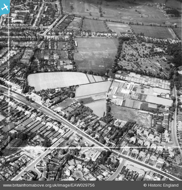
EAW029756 ENGLAND (1950). The Sandy Hill Nursery and the surrounding area, Shirley, 1950. This image was marked by Aerofilms Ltd for photo editing.
© Copyright OpenStreetMap contributors and licensed by the OpenStreetMap Foundation. 2025. Cartography is licensed as CC BY-SA.
Nearby Images (14)
Details
| Title | [EAW029756] The Sandy Hill Nursery and the surrounding area, Shirley, 1950. This image was marked by Aerofilms Ltd for photo editing. |
| Reference | EAW029756 |
| Date | 31-May-1950 |
| Link | |
| Place name | SHIRLEY |
| Parish | |
| District | |
| Country | ENGLAND |
| Easting / Northing | 411662, 280154 |
| Longitude / Latitude | -1.8285034726071, 52.418878241537 |
| National Grid Reference | SP117802 |
Pins
Be the first to add a comment to this image!


![[EAW029756] The Sandy Hill Nursery and the surrounding area, Shirley, 1950. This image was marked by Aerofilms Ltd for photo editing.](http://britainfromabove.org.uk/sites/all/libraries/aerofilms-images/public/100x100/EAW/029/EAW029756.jpg)
![[EAW029755] The Sandy Hill Nursery and the surrounding area, Shirley, 1950. This image was marked by Aerofilms Ltd for photo editing.](http://britainfromabove.org.uk/sites/all/libraries/aerofilms-images/public/100x100/EAW/029/EAW029755.jpg)
![[EAW029758] The Sandy Hill Nursery and the surrounding area, Shirley, 1950. This image was marked by Aerofilms Ltd for photo editing.](http://britainfromabove.org.uk/sites/all/libraries/aerofilms-images/public/100x100/EAW/029/EAW029758.jpg)
![[EAW029762] The Sandy Hill Nursery and the surrounding area, Shirley, 1950. This image was marked by Aerofilms Ltd for photo editing.](http://britainfromabove.org.uk/sites/all/libraries/aerofilms-images/public/100x100/EAW/029/EAW029762.jpg)
![[EAW029757] The Sandy Hill Nursery and the surrounding area, Shirley, 1950. This image was marked by Aerofilms Ltd for photo editing.](http://britainfromabove.org.uk/sites/all/libraries/aerofilms-images/public/100x100/EAW/029/EAW029757.jpg)
![[EAW029761] The Sandy Hill Nursery, Shirley, 1950. This image was marked by Aerofilms Ltd for photo editing.](http://britainfromabove.org.uk/sites/all/libraries/aerofilms-images/public/100x100/EAW/029/EAW029761.jpg)
![[EAW029759] The Sandy Hill Nursery and the surrounding area, Shirley, 1950. This image was marked by Aerofilms Ltd for photo editing.](http://britainfromabove.org.uk/sites/all/libraries/aerofilms-images/public/100x100/EAW/029/EAW029759.jpg)
![[EAW029760] The Sandy Hill Nursery and the surrounding area, Shirley, 1950. This image was marked by Aerofilms Ltd for photo editing.](http://britainfromabove.org.uk/sites/all/libraries/aerofilms-images/public/100x100/EAW/029/EAW029760.jpg)
![[EAW029754] The Sandy Hill Nursery, Shirley, 1950](http://britainfromabove.org.uk/sites/all/libraries/aerofilms-images/public/100x100/EAW/029/EAW029754.jpg)
![[EPW059190] Sandy Hill Nursery on Olton Road, Shirley, 1938](http://britainfromabove.org.uk/sites/all/libraries/aerofilms-images/public/100x100/EPW/059/EPW059190.jpg)
![[EPW059192] Sandy Hill Nursery on Olton Road, Shirley, 1938](http://britainfromabove.org.uk/sites/all/libraries/aerofilms-images/public/100x100/EPW/059/EPW059192.jpg)
![[EPW059191] Sandy Hill Nursery on Olton Road, Shirley, 1938](http://britainfromabove.org.uk/sites/all/libraries/aerofilms-images/public/100x100/EPW/059/EPW059191.jpg)
![[EPW059194] Sandy Hill Nursery on Olton Road and Arnold Grove, Shirley, 1938](http://britainfromabove.org.uk/sites/all/libraries/aerofilms-images/public/100x100/EPW/059/EPW059194.jpg)
![[EPW059193] Sandy Hill Nursery on Olton Road and Arnold Grove, Shirley, 1938](http://britainfromabove.org.uk/sites/all/libraries/aerofilms-images/public/100x100/EPW/059/EPW059193.jpg)