
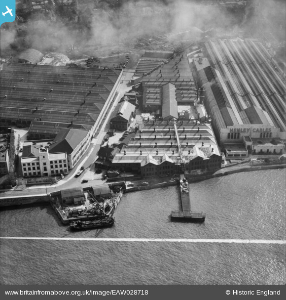
EAW028718 ENGLAND (1950). The Amalgamated Press Ltd Printing Works on Crete Hall Road and environs, Rosherville, 1950. This image was marked by Aerofilms Ltd for photo editing.
© Copyright OpenStreetMap contributors and licensed by the OpenStreetMap Foundation. 2026. Cartography is licensed as CC BY-SA.
Nearby Images (27)
EAW028718

EAW031124

EAW042093

EPW036578

EAW028716

EAW028719

EPW036587

EAW031131

EAW031123

EAW031126

EAW031127

EAW028720

EPW036577

EAW028717

EAW031129

EAW031125

EAW031128

EAW031130

EPW036580

EAW031132

EPW036582

EPW036581

EPW032817

EPW032816

EPW032818

EPW036576

EPW017660

Details
| Title | [EAW028718] The Amalgamated Press Ltd Printing Works on Crete Hall Road and environs, Rosherville, 1950. This image was marked by Aerofilms Ltd for photo editing. |
| Reference | EAW028718 |
| Date | 20-April-1950 |
| Link | |
| Place name | ROSHERVILLE |
| Parish | |
| District | |
| Country | ENGLAND |
| Easting / Northing | 563565, 174450 |
| Longitude / Latitude | 0.3539478079454, 51.444896405915 |
| National Grid Reference | TQ636745 |
Pins

MB |
Sunday 23rd of February 2014 10:24:19 AM |