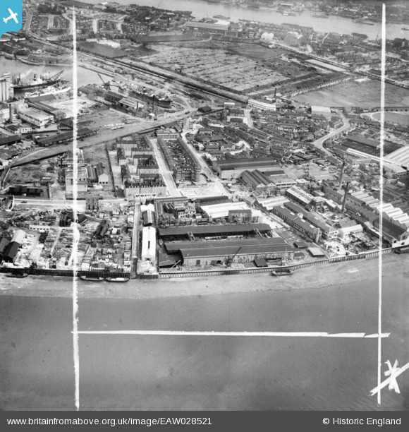
EAW028521 ENGLAND (1950). The Napier Yard and environs, Millwall, 1950. This image was marked by Aerofilms Ltd for photo editing.
© Copyright OpenStreetMap contributors and licensed by the OpenStreetMap Foundation. 2026. Cartography is licensed as CC BY-SA.
Nearby Images (11)
Details
| Title | [EAW028521] The Napier Yard and environs, Millwall, 1950. This image was marked by Aerofilms Ltd for photo editing. |
| Reference | EAW028521 |
| Date | 5-April-1950 |
| Link | |
| Place name | MILLWALL |
| Parish | |
| District | |
| Country | ENGLAND |
| Easting / Northing | 537511, 178512 |
| Longitude / Latitude | -0.019164566224265, 51.488329347548 |
| National Grid Reference | TQ375785 |
Pins

moses72 |
Friday 5th of September 2014 04:12:14 PM | |

moses72 |
Friday 5th of September 2014 04:10:12 PM | |

moses72 |
Friday 5th of September 2014 04:08:47 PM | |

moses72 |
Friday 5th of September 2014 04:08:16 PM |


![[EAW028521] The Napier Yard and environs, Millwall, 1950. This image was marked by Aerofilms Ltd for photo editing.](http://britainfromabove.org.uk/sites/all/libraries/aerofilms-images/public/100x100/EAW/028/EAW028521.jpg)
![[EAW028529] The Napier Yard, Deptford Power Stations and environs, Millwall, 1950. This image was marked by Aerofilms Ltd for photo editing.](http://britainfromabove.org.uk/sites/all/libraries/aerofilms-images/public/100x100/EAW/028/EAW028529.jpg)
![[EAW028526] The Napier Yard and environs, Millwall, 1950. This image was marked by Aerofilms Ltd for photo editing.](http://britainfromabove.org.uk/sites/all/libraries/aerofilms-images/public/100x100/EAW/028/EAW028526.jpg)
![[EAW028528] The Napier Yard and environs, Millwall, 1950. This image was marked by Aerofilms Ltd for photo editing.](http://britainfromabove.org.uk/sites/all/libraries/aerofilms-images/public/100x100/EAW/028/EAW028528.jpg)
![[EAW028525] The Napier Yard, Deptford Power Stations and environs, Millwall, 1950. This image was marked by Aerofilms Ltd for photo editing.](http://britainfromabove.org.uk/sites/all/libraries/aerofilms-images/public/100x100/EAW/028/EAW028525.jpg)
![[EAW028523] The Napier Yard and environs, Millwall, 1950. This image was marked by Aerofilms Ltd for photo editing.](http://britainfromabove.org.uk/sites/all/libraries/aerofilms-images/public/100x100/EAW/028/EAW028523.jpg)
![[EAW028524] The Napier Yard and environs, Millwall, 1950. This image was marked by Aerofilms Ltd for photo editing.](http://britainfromabove.org.uk/sites/all/libraries/aerofilms-images/public/100x100/EAW/028/EAW028524.jpg)
![[EAW028522] The Napier Yard, Deptford Power Stations and environs, Millwall, 1950. This image was marked by Aerofilms Ltd for photo editing.](http://britainfromabove.org.uk/sites/all/libraries/aerofilms-images/public/100x100/EAW/028/EAW028522.jpg)
![[EAW028527] The Napier Yard and environs, Millwall, 1950. This image was marked by Aerofilms Ltd for photo editing.](http://britainfromabove.org.uk/sites/all/libraries/aerofilms-images/public/100x100/EAW/028/EAW028527.jpg)
![[EAW021719] A cityscape over Deptford and Millwall, Isle of Dogs, 1949. This image has been produced from a print.](http://britainfromabove.org.uk/sites/all/libraries/aerofilms-images/public/100x100/EAW/021/EAW021719.jpg)
![[EPW025712] Maconochie Brothers Meat, Fruit Preserving and Confectionery Works, Millwall, 1929. This image has been produced from a print.](http://britainfromabove.org.uk/sites/all/libraries/aerofilms-images/public/100x100/EPW/025/EPW025712.jpg)