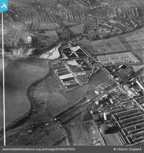
EAW027650 ENGLAND (1949). Lea Bridge Pumping Station, the Porters Field Estate and environs, Lea Bridge, 1949. This image was marked by Aerofilms Ltd for photo editing.
© Copyright OpenStreetMap contributors and licensed by the OpenStreetMap Foundation. 2026. Cartography is licensed as CC BY-SA.
Nearby Images (17)
Details
| Title | [EAW027650] Lea Bridge Pumping Station, the Porters Field Estate and environs, Lea Bridge, 1949. This image was marked by Aerofilms Ltd for photo editing. |
| Reference | EAW027650 |
| Date | 14-November-1949 |
| Link | |
| Place name | LEA BRIDGE |
| Parish | |
| District | |
| Country | ENGLAND |
| Easting / Northing | 536160, 186727 |
| Longitude / Latitude | -0.035437450208212, 51.56248605128 |
| National Grid Reference | TQ362867 |


![[EAW027650] Lea Bridge Pumping Station, the Porters Field Estate and environs, Lea Bridge, 1949. This image was marked by Aerofilms Ltd for photo editing.](http://britainfromabove.org.uk/sites/all/libraries/aerofilms-images/public/100x100/EAW/027/EAW027650.jpg)
![[EAW027648] Lea Bridge Pumping Station, the Porters Field Estate and environs, Lea Bridge, 1949. This image was marked by Aerofilms Ltd for photo editing.](http://britainfromabove.org.uk/sites/all/libraries/aerofilms-images/public/100x100/EAW/027/EAW027648.jpg)
![[EAW027644] Lea Bridge Pumping Station, Lea Bridge, 1949. This image has been produced from a print marked by Aerofilms Ltd for photo editing.](http://britainfromabove.org.uk/sites/all/libraries/aerofilms-images/public/100x100/EAW/027/EAW027644.jpg)
![[EAW027647] Lea Bridge Pumping Station, Lea Bridge, 1949. This image was marked by Aerofilms Ltd for photo editing.](http://britainfromabove.org.uk/sites/all/libraries/aerofilms-images/public/100x100/EAW/027/EAW027647.jpg)
![[EAW027645] Lea Bridge Pumping Station, Lea Bridge, 1949. This image has been produced from a damaged negative.](http://britainfromabove.org.uk/sites/all/libraries/aerofilms-images/public/100x100/EAW/027/EAW027645.jpg)
![[EAW027646] Lea Bridge Pumping Station, Lea Bridge, 1949. This image has been produced from a damaged negative.](http://britainfromabove.org.uk/sites/all/libraries/aerofilms-images/public/100x100/EAW/027/EAW027646.jpg)
![[EAW027643] Lea Bridge Pumping Station, Lea Bridge, 1949. This image has been produced from a damaged negative.](http://britainfromabove.org.uk/sites/all/libraries/aerofilms-images/public/100x100/EAW/027/EAW027643.jpg)
![[EAW043554] Lea Bridge Pumping Station and Filter Beds, Leyton, 1952](http://britainfromabove.org.uk/sites/all/libraries/aerofilms-images/public/100x100/EAW/043/EAW043554.jpg)
![[EAW027642] Lea Bridge Pumping Station, Lea Bridge, 1949. This image was marked by Aerofilms Ltd for photo editing.](http://britainfromabove.org.uk/sites/all/libraries/aerofilms-images/public/100x100/EAW/027/EAW027642.jpg)
![[EAW027649] Lea Bridge Pumping Station, the Porters Field Estate, Clapton Stadium and environs, Lea Bridge, 1949. This image was marked by Aerofilms Ltd for photo editing.](http://britainfromabove.org.uk/sites/all/libraries/aerofilms-images/public/100x100/EAW/027/EAW027649.jpg)
![[EPW051980] The Lea Bridge Pumping Station and filter beds, Lea Bridge, 1936. This image has been produced from a print.](http://britainfromabove.org.uk/sites/all/libraries/aerofilms-images/public/100x100/EPW/051/EPW051980.jpg)
![[EPW051547] Lea Bridge Pumping Station and Filter Beds (Metropolitan Water Board), Lea Bridge, 1936](http://britainfromabove.org.uk/sites/all/libraries/aerofilms-images/public/100x100/EPW/051/EPW051547.jpg)
![[EPW051549] Lea Bridge Pumping Station and Filter Beds (Metropolitan Water Board), Lea Bridge, 1936](http://britainfromabove.org.uk/sites/all/libraries/aerofilms-images/public/100x100/EPW/051/EPW051549.jpg)
![[EPW051545] Lea Bridge Pumping Station and Filter Beds (Metropolitan Water Board), Lea Bridge, 1936](http://britainfromabove.org.uk/sites/all/libraries/aerofilms-images/public/100x100/EPW/051/EPW051545.jpg)
![[EAW027651] Lea Bridge Pumping Station, the Porters Field Estate and environs, Lea Bridge, 1949. This image was marked by Aerofilms Ltd for photo editing.](http://britainfromabove.org.uk/sites/all/libraries/aerofilms-images/public/100x100/EAW/027/EAW027651.jpg)
![[EAW027652] Lea Bridge Pumping Station and the Porters Field Estate, Lea Bridge, 1949. This image was marked by Aerofilms Ltd for photo editing.](http://britainfromabove.org.uk/sites/all/libraries/aerofilms-images/public/100x100/EAW/027/EAW027652.jpg)
![[EPW051546] Lea Bridge Pumping Station and Filter Beds (Metropolitan Water Board), Lea Bridge, 1936](http://britainfromabove.org.uk/sites/all/libraries/aerofilms-images/public/100x100/EPW/051/EPW051546.jpg)
