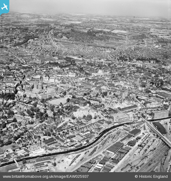
EAW025937 ENGLAND (1949). Nottingham Castle and the city centre, Nottingham, from the south-west, 1949
© Copyright OpenStreetMap contributors and licensed by the OpenStreetMap Foundation. 2026. Cartography is licensed as CC BY-SA.
Nearby Images (25)
Details
| Title | [EAW025937] Nottingham Castle and the city centre, Nottingham, from the south-west, 1949 |
| Reference | EAW025937 |
| Date | 15-August-1949 |
| Link | |
| Place name | NOTTINGHAM |
| Parish | |
| District | |
| Country | ENGLAND |
| Easting / Northing | 456869, 339331 |
| Longitude / Latitude | -1.153530924837, 52.948030800155 |
| National Grid Reference | SK569393 |
Pins

redmist |
Sunday 26th of May 2019 08:22:53 PM | |

Peter Kazmierczak |
Monday 5th of May 2014 08:06:32 PM | |

Peter Kazmierczak |
Monday 5th of May 2014 08:05:34 PM | |

Peter Kazmierczak |
Monday 5th of May 2014 08:04:37 PM | |

Peter Kazmierczak |
Monday 5th of May 2014 08:03:34 PM | |

Peter Kazmierczak |
Monday 5th of May 2014 08:02:26 PM | |

Peter Kazmierczak |
Monday 5th of May 2014 08:01:05 PM | |

Peter Kazmierczak |
Monday 5th of May 2014 07:59:58 PM | |

Peter Kazmierczak |
Monday 5th of May 2014 07:58:46 PM |


![[EAW025937] Nottingham Castle and the city centre, Nottingham, from the south-west, 1949](http://britainfromabove.org.uk/sites/all/libraries/aerofilms-images/public/100x100/EAW/025/EAW025937.jpg)
![[EAW009531] The city, Nottingham, from the south-west, 1947](http://britainfromabove.org.uk/sites/all/libraries/aerofilms-images/public/100x100/EAW/009/EAW009531.jpg)
![[EAW044654] Nottingham Castle Museum and Art Gallery and environs, Nottingham, 1952](http://britainfromabove.org.uk/sites/all/libraries/aerofilms-images/public/100x100/EAW/044/EAW044654.jpg)
![[EPW045368] Gunn and Moore Ltd Cricket Bat Manufacturers and the Midland Railway Coal and Timber Yards, Nottingham, 1934](http://britainfromabove.org.uk/sites/all/libraries/aerofilms-images/public/100x100/EPW/045/EPW045368.jpg)
![[EPW045365] Gunn and Moore Ltd Cricket Bat Manufacturers and the Midland Railway Coal and Timber Yards, Nottingham, 1934](http://britainfromabove.org.uk/sites/all/libraries/aerofilms-images/public/100x100/EPW/045/EPW045365.jpg)
![[EAW042518] Nottingham Castle, Nottingham, 1952](http://britainfromabove.org.uk/sites/all/libraries/aerofilms-images/public/100x100/EAW/042/EAW042518.jpg)
![[EPW045367] Gunn and Moore Ltd Cricket Bat Manufacturers and the Midland Railway Coal and Timber Yards, Nottingham, 1934](http://britainfromabove.org.uk/sites/all/libraries/aerofilms-images/public/100x100/EPW/045/EPW045367.jpg)
![[EPW045366] Gunn and Moore Ltd Cricket Bat Manufacturers and the Midland Railway Coal and Timber Yards, Nottingham, 1934](http://britainfromabove.org.uk/sites/all/libraries/aerofilms-images/public/100x100/EPW/045/EPW045366.jpg)
![[EPW045369] Gunn and Moore Ltd Cricket Bat Manufacturers and the Midland Railway Coal and Timber Yards, Nottingham, 1934](http://britainfromabove.org.uk/sites/all/libraries/aerofilms-images/public/100x100/EPW/045/EPW045369.jpg)
![[EAW050485] Nottingham Castle, Museum & Art Gallery and environs, Nottingham, 1953](http://britainfromabove.org.uk/sites/all/libraries/aerofilms-images/public/100x100/EAW/050/EAW050485.jpg)
![[EPW013012] Nottingham Castle, Nottingham, 1925](http://britainfromabove.org.uk/sites/all/libraries/aerofilms-images/public/100x100/EPW/013/EPW013012.jpg)
![[EPW045370] Gunn and Moore Ltd Cricket Bat Manufacturers, Nottingham, 1934](http://britainfromabove.org.uk/sites/all/libraries/aerofilms-images/public/100x100/EPW/045/EPW045370.jpg)
![[EAW006396] The castle and environs, Nottingham, 1947. This image has been produced from a print.](http://britainfromabove.org.uk/sites/all/libraries/aerofilms-images/public/100x100/EAW/006/EAW006396.jpg)
![[EPW038632] The Castle, Nottingham, 1932](http://britainfromabove.org.uk/sites/all/libraries/aerofilms-images/public/100x100/EPW/038/EPW038632.jpg)
![[EPW019376] The Viyella Garments Factory on Castle Boulevard, Nottingham, 1927](http://britainfromabove.org.uk/sites/all/libraries/aerofilms-images/public/100x100/EPW/019/EPW019376.jpg)
![[EPW012557] Nottingham Castle, Castle Museum and Art Gallery and the city, Nottingham, 1925. This image has been produced from a print.](http://britainfromabove.org.uk/sites/all/libraries/aerofilms-images/public/100x100/EPW/012/EPW012557.jpg)
![[EAW006395] The castle and environs, Nottingham, 1947. This image has been produced from a print.](http://britainfromabove.org.uk/sites/all/libraries/aerofilms-images/public/100x100/EAW/006/EAW006395.jpg)
![[EAW006400] The castle and environs, Nottingham, 1947. This image has been produced from a print.](http://britainfromabove.org.uk/sites/all/libraries/aerofilms-images/public/100x100/EAW/006/EAW006400.jpg)
![[EAW006397] The site of Nottingham Castle and the Castle Museum and Art Gallery, Nottingham, 1947](http://britainfromabove.org.uk/sites/all/libraries/aerofilms-images/public/100x100/EAW/006/EAW006397.jpg)
![[EPW038629] The Castle, Nottingham, 1932](http://britainfromabove.org.uk/sites/all/libraries/aerofilms-images/public/100x100/EPW/038/EPW038629.jpg)
![[EAW006399] The site of Nottingham Castle and the Castle Museum and Art Gallery, Nottingham, 1947](http://britainfromabove.org.uk/sites/all/libraries/aerofilms-images/public/100x100/EAW/006/EAW006399.jpg)
![[EAW006401] The site of Nottingham Castle and the city centre, Nottingham, 1947](http://britainfromabove.org.uk/sites/all/libraries/aerofilms-images/public/100x100/EAW/006/EAW006401.jpg)
![[EAW006398] The castle and environs, Nottingham, 1947. This image has been produced from a print.](http://britainfromabove.org.uk/sites/all/libraries/aerofilms-images/public/100x100/EAW/006/EAW006398.jpg)
![[EPW054987] Nottingham Castle Museum and Art Gallery and environs, Nottingham, 1937](http://britainfromabove.org.uk/sites/all/libraries/aerofilms-images/public/100x100/EPW/054/EPW054987.jpg)
![[EAW025942] Nottingham Castle and the city centre, Nottingham, from the south, 1949](http://britainfromabove.org.uk/sites/all/libraries/aerofilms-images/public/100x100/EAW/025/EAW025942.jpg)