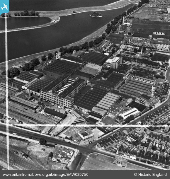
EAW025750 ENGLAND (1949). Works off Blackhorse Lane, Walthamstow, 1949. This image has been produced from a print marked by Aerofilms Ltd for photo editing.
© Copyright OpenStreetMap contributors and licensed by the OpenStreetMap Foundation. 2026. Cartography is licensed as CC BY-SA.
Nearby Images (27)
Details
| Title | [EAW025750] Works off Blackhorse Lane, Walthamstow, 1949. This image has been produced from a print marked by Aerofilms Ltd for photo editing. |
| Reference | EAW025750 |
| Date | 8-August-1949 |
| Link | |
| Place name | WALTHAMSTOW |
| Parish | |
| District | |
| Country | ENGLAND |
| Easting / Northing | 535747, 189564 |
| Longitude / Latitude | -0.040296025031042, 51.588082112232 |
| National Grid Reference | TQ357896 |


![[EAW025750] Works off Blackhorse Lane, Walthamstow, 1949. This image has been produced from a print marked by Aerofilms Ltd for photo editing.](http://britainfromabove.org.uk/sites/all/libraries/aerofilms-images/public/100x100/EAW/025/EAW025750.jpg)
![[EAW025746] Works off Blackhorse Lane, Walthamstow, 1949. This image has been produced from a print marked by Aerofilms Ltd for photo editing.](http://britainfromabove.org.uk/sites/all/libraries/aerofilms-images/public/100x100/EAW/025/EAW025746.jpg)
![[EAW025747] Works off Blackhorse Lane and the High and Low Maynard Reservoirs, Walthamstow, 1949. This image has been produced from a print marked by Aerofilms Ltd for photo editing.](http://britainfromabove.org.uk/sites/all/libraries/aerofilms-images/public/100x100/EAW/025/EAW025747.jpg)
![[EAW025753] Works off Blackhorse Lane, Walthamstow, 1949. This image has been produced from a print.](http://britainfromabove.org.uk/sites/all/libraries/aerofilms-images/public/100x100/EAW/025/EAW025753.jpg)
![[EAW025752] Works off Blackhorse Lane, Walthamstow, 1949. This image has been produced from a print marked by Aerofilms Ltd for photo editing.](http://britainfromabove.org.uk/sites/all/libraries/aerofilms-images/public/100x100/EAW/025/EAW025752.jpg)
![[EAW025749] Works off Blackhorse Lane, Walthamstow, 1949. This image has been produced from a print marked by Aerofilms Ltd for photo editing.](http://britainfromabove.org.uk/sites/all/libraries/aerofilms-images/public/100x100/EAW/025/EAW025749.jpg)
![[EPW037542] The Micanite and Insulators Co Ltd Empire Works, Walthamstow, 1932](http://britainfromabove.org.uk/sites/all/libraries/aerofilms-images/public/100x100/EPW/037/EPW037542.jpg)
![[EPW037926] Factories next to the High Maynard Reservoir, Higham Hill, 1932](http://britainfromabove.org.uk/sites/all/libraries/aerofilms-images/public/100x100/EPW/037/EPW037926.jpg)
![[EAW025751] Works off Blackhorse Lane, Walthamstow, 1949. This image has been produced from a print.](http://britainfromabove.org.uk/sites/all/libraries/aerofilms-images/public/100x100/EAW/025/EAW025751.jpg)
![[EPW037547] The Micanite and Insulators Co Ltd Empire Works, Walthamstow, 1932](http://britainfromabove.org.uk/sites/all/libraries/aerofilms-images/public/100x100/EPW/037/EPW037547.jpg)
![[EPW037918] Factories next to the High Maynard Reservoir, Higham Hill, 1932](http://britainfromabove.org.uk/sites/all/libraries/aerofilms-images/public/100x100/EPW/037/EPW037918.jpg)
![[EPW037546] The Micanite and Insulators Co Ltd Empire Works and other factories, Walthamstow, 1932](http://britainfromabove.org.uk/sites/all/libraries/aerofilms-images/public/100x100/EPW/037/EPW037546.jpg)
![[EAW025748] Works off Blackhorse Lane, Walthamstow, 1949. This image has been produced from a print marked by Aerofilms Ltd for photo editing.](http://britainfromabove.org.uk/sites/all/libraries/aerofilms-images/public/100x100/EAW/025/EAW025748.jpg)
![[EPW037545] The Micanite and Insulators Co Ltd Empire Works and other factories, Walthamstow, 1932](http://britainfromabove.org.uk/sites/all/libraries/aerofilms-images/public/100x100/EPW/037/EPW037545.jpg)
![[EPW037925] Factories next to the High Maynard Reservoir, Higham Hill, 1932](http://britainfromabove.org.uk/sites/all/libraries/aerofilms-images/public/100x100/EPW/037/EPW037925.jpg)
![[EPW037927] Factories next to the High Maynard Reservoir, Higham Hill, 1932](http://britainfromabove.org.uk/sites/all/libraries/aerofilms-images/public/100x100/EPW/037/EPW037927.jpg)
![[EPW037541] The Micanite and Insulators Co Ltd Empire Works and other factories, Walthamstow, 1932](http://britainfromabove.org.uk/sites/all/libraries/aerofilms-images/public/100x100/EPW/037/EPW037541.jpg)
![[EPW037923] Factories next to the High Maynard Reservoir, Higham Hill, 1932](http://britainfromabove.org.uk/sites/all/libraries/aerofilms-images/public/100x100/EPW/037/EPW037923.jpg)
![[EPW037924] Factories next to the High Maynard Reservoir, Higham Hill, 1932](http://britainfromabove.org.uk/sites/all/libraries/aerofilms-images/public/100x100/EPW/037/EPW037924.jpg)
![[EPW037540] The Micanite and Insulators Co Ltd Empire Works, Walthamstow, 1932](http://britainfromabove.org.uk/sites/all/libraries/aerofilms-images/public/100x100/EPW/037/EPW037540.jpg)
![[EPW037920] Factories next to the High Maynard Reservoir, Higham Hill, 1932](http://britainfromabove.org.uk/sites/all/libraries/aerofilms-images/public/100x100/EPW/037/EPW037920.jpg)
![[EPW037921] Factories next to the High Maynard Reservoir, Higham Hill, 1932](http://britainfromabove.org.uk/sites/all/libraries/aerofilms-images/public/100x100/EPW/037/EPW037921.jpg)
![[EPW037543] The Micanite and Insulators Co Ltd Empire Works and other factories, Walthamstow, 1932](http://britainfromabove.org.uk/sites/all/libraries/aerofilms-images/public/100x100/EPW/037/EPW037543.jpg)
![[EPW037922] Factories next to the High Maynard Reservoir, Higham Hill, 1932](http://britainfromabove.org.uk/sites/all/libraries/aerofilms-images/public/100x100/EPW/037/EPW037922.jpg)
![[EPW037919] Factories next to the High Maynard Reservoir, Higham Hill, 1932](http://britainfromabove.org.uk/sites/all/libraries/aerofilms-images/public/100x100/EPW/037/EPW037919.jpg)
![[EPW037544] The Micanite and Insulators Co Ltd Empire Works and other factories, Walthamstow, 1932](http://britainfromabove.org.uk/sites/all/libraries/aerofilms-images/public/100x100/EPW/037/EPW037544.jpg)
![[EAW043552] The area around Blackhorse Road Station and Higham Hill looking towards Banbury Reservoir, from the south, Walthamstow, from the south, 1952](http://britainfromabove.org.uk/sites/all/libraries/aerofilms-images/public/100x100/EAW/043/EAW043552.jpg)
