
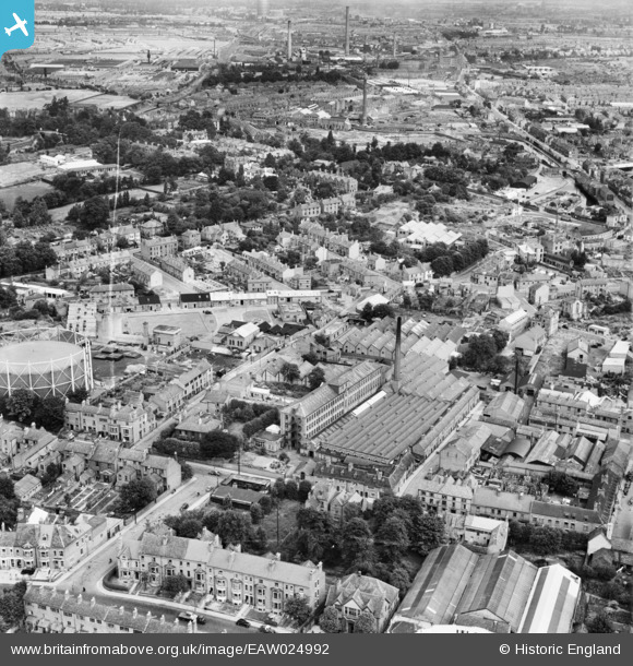
EAW024992 ENGLAND (1949). The Leigh Worsted Mill, Coventry, 1949. This image was marked by Aerofilms Ltd for photo editing.
© Copyright OpenStreetMap contributors and licensed by the OpenStreetMap Foundation. 2026. Cartography is licensed as CC BY-SA.
Nearby Images (22)
EAW024992

EAW024993

EAW024998

EAW025001

EAW024989

EAW025000

EAW031596

EPW053110

EAW024990

EAW031595

EAW031592

EAW031597

EAW024994

EAW031593

EAW031594

EAW025002

EAW024997

EAW024999

EPW061105

EPW035765

EPW035764

EPW035762

Details
| Title | [EAW024992] The Leigh Worsted Mill, Coventry, 1949. This image was marked by Aerofilms Ltd for photo editing. |
| Reference | EAW024992 |
| Date | 21-July-1949 |
| Link | |
| Place name | COVENTRY |
| Parish | |
| District | |
| Country | ENGLAND |
| Easting / Northing | 433016, 279381 |
| Longitude / Latitude | -1.5145650212408, 52.411055995677 |
| National Grid Reference | SP330794 |
Pins

RayG |
Tuesday 30th of December 2025 03:36:26 PM | |
|
Triggy |
Wednesday 19th of February 2014 08:56:10 PM | |
I think the viscose plant was about a mile to the north east Stoney Stanton Road/Old Church Road. It used to be called British Celanese. I worked there Summer 1967. |
RayG |
Tuesday 30th of December 2025 03:27:58 PM |
|
dutchman |
Wednesday 19th of February 2014 08:10:42 PM | |
|
dutchman |
Wednesday 19th of February 2014 08:09:44 PM | |
|
dutchman |
Wednesday 19th of February 2014 08:08:51 PM | |
|
JG |
Monday 10th of February 2014 10:54:44 PM | |
|
JG |
Monday 10th of February 2014 10:54:20 PM | |
|
Coventry kid |
Friday 27th of December 2013 01:09:25 PM | |
|
Coventry kid |
Friday 27th of December 2013 01:08:34 PM |