
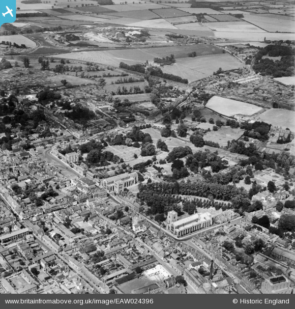
EAW024396 ENGLAND (1949). The Abbey Gardens and environs, Bury St Edmunds, 1949
© Copyright OpenStreetMap contributors and licensed by the OpenStreetMap Foundation. 2026. Cartography is licensed as CC BY-SA.
Nearby Images (13)
EAW024396

EAW029744

EAW024389

EAW024395

EAW024397

EPW001753

EAW024398

EPW025024

EPW025022

EPW025021

EPW025020

EPW001773

EPW025023

Details
| Title | [EAW024396] The Abbey Gardens and environs, Bury St Edmunds, 1949 |
| Reference | EAW024396 |
| Date | 6-July-1949 |
| Link | |
| Place name | BURY ST EDMUNDS |
| Parish | BURY ST. EDMUNDS |
| District | |
| Country | ENGLAND |
| Easting / Northing | 585695, 264230 |
| Longitude / Latitude | 0.72028884574872, 52.244478993917 |
| National Grid Reference | TL857642 |
Pins

H.E. |
Tuesday 21st of May 2024 04:29:05 PM | |

Matt Aldred edob.mattaldred.com |
Sunday 22nd of November 2020 08:56:10 PM | |
|
Matt Aldred edob.mattaldred.com |
Tuesday 7th of January 2020 02:48:42 PM | |
|
cptpies |
Monday 16th of December 2013 01:55:02 PM |
User Comment Contributions
Type 22 AA variant, Bury St Edmunds. |
cptpies |
Thursday 19th of December 2013 01:54:28 PM |