
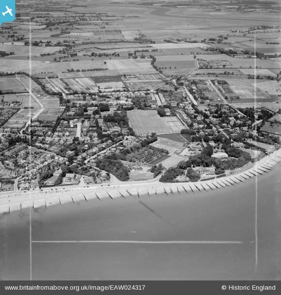
EAW024317 ENGLAND (1949). Cobbolds Point and environs, Felixstowe, 1949. This image was marked by Aerofilms Ltd for photo editing.
© Copyright OpenStreetMap contributors and licensed by the OpenStreetMap Foundation. 2026. Cartography is licensed as CC BY-SA.
Nearby Images (8)
EAW024317

EAW024314

EAW024318

EAW024316

EAW024311

EAW024312

EAW024313

EAW024315

Details
| Title | [EAW024317] Cobbolds Point and environs, Felixstowe, 1949. This image was marked by Aerofilms Ltd for photo editing. |
| Reference | EAW024317 |
| Date | 4-July-1949 |
| Link | |
| Place name | FELIXSTOWE |
| Parish | FELIXSTOWE |
| District | |
| Country | ENGLAND |
| Easting / Northing | 631337, 235026 |
| Longitude / Latitude | 1.3679454552093, 51.965060319164 |
| National Grid Reference | TM313350 |
Pins

Ferrers |
Sunday 25th of September 2022 01:39:55 PM | |

Matt Aldred edob.mattaldred.com |
Friday 1st of March 2019 03:39:27 PM | |

Where's Canning Town? |
Monday 10th of March 2014 08:41:41 PM |
User Comment Contributions
No prizes for guessing who was the famous person who stayed in the house, to the far left of photo, for six weeks in October 1936. Incidentally few photographs of Beach House exist. It was demolished in 1989. |
Where's Canning Town? |
Saturday 8th of March 2014 10:54:34 PM |