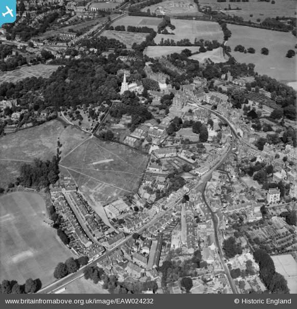
EAW024232 ENGLAND (1949). Harrow School, Harrow on the Hill, 1949
© Copyright OpenStreetMap contributors and licensed by the OpenStreetMap Foundation. 2026. Cartography is licensed as CC BY-SA.
Nearby Images (25)
Details
| Title | [EAW024232] Harrow School, Harrow on the Hill, 1949 |
| Reference | EAW024232 |
| Date | 27-June-1949 |
| Link | |
| Place name | HARROW ON THE HILL |
| Parish | |
| District | |
| Country | ENGLAND |
| Easting / Northing | 515193, 187349 |
| Longitude / Latitude | -0.33760297636288, 51.572750459898 |
| National Grid Reference | TQ152873 |
Pins

The Laird |
Thursday 20th of February 2020 05:28:07 PM | |

The Laird |
Thursday 20th of February 2020 05:26:20 PM | |

The Laird |
Thursday 20th of February 2020 05:25:20 PM | |

czyrko |
Sunday 27th of April 2014 07:46:09 AM | |

czyrko |
Sunday 27th of April 2014 07:45:16 AM | |

Class31 |
Sunday 6th of April 2014 05:01:59 PM |


![[EAW024232] Harrow School, Harrow on the Hill, 1949](http://britainfromabove.org.uk/sites/all/libraries/aerofilms-images/public/100x100/EAW/024/EAW024232.jpg)
![[EPW025547] St Mary's Church and Harrow School, Harrow on the Hill, 1928. This image has been produced from a print.](http://britainfromabove.org.uk/sites/all/libraries/aerofilms-images/public/100x100/EPW/025/EPW025547.jpg)
![[EPW000467] Harrow on the Hill, from the south-west, 1920](http://britainfromabove.org.uk/sites/all/libraries/aerofilms-images/public/100x100/EPW/000/EPW000467.jpg)
![[EPW000469] Harrow on the Hill, from the south-west, 1920](http://britainfromabove.org.uk/sites/all/libraries/aerofilms-images/public/100x100/EPW/000/EPW000469.jpg)
![[EPW000468] Harrow on the Hill, from the south-west, 1920](http://britainfromabove.org.uk/sites/all/libraries/aerofilms-images/public/100x100/EPW/000/EPW000468.jpg)
![[EPW000462] Harrow School, Harrow on the Hill, 1920](http://britainfromabove.org.uk/sites/all/libraries/aerofilms-images/public/100x100/EPW/000/EPW000462.jpg)
![[EPW000463] Harrow School, Harrow on the Hill, 1920](http://britainfromabove.org.uk/sites/all/libraries/aerofilms-images/public/100x100/EPW/000/EPW000463.jpg)
![[EPW053679] West Street and the town, Harrow on the Hill, from the north-west, 1937](http://britainfromabove.org.uk/sites/all/libraries/aerofilms-images/public/100x100/EPW/053/EPW053679.jpg)
![[EAW042771] St Mary's Church, the Speech Room and Old Schools, Harrow on the Hill, 1952](http://britainfromabove.org.uk/sites/all/libraries/aerofilms-images/public/100x100/EAW/042/EAW042771.jpg)
![[EPW006290] St Mary's Church, Harrow on the Hill, 1921](http://britainfromabove.org.uk/sites/all/libraries/aerofilms-images/public/100x100/EPW/006/EPW006290.jpg)
![[EPW005357] St Mary's Church and The Speech Room, Harrow on the Hill, 1921](http://britainfromabove.org.uk/sites/all/libraries/aerofilms-images/public/100x100/EPW/005/EPW005357.jpg)
![[EAW014888] St Mary's Church, Harrow School and environs, Harrow on the Hill, 1948. This image has been produced from a print.](http://britainfromabove.org.uk/sites/all/libraries/aerofilms-images/public/100x100/EAW/014/EAW014888.jpg)
![[EAW042768] The Speech Room and the High Street, Harrow on the Hill, 1952](http://britainfromabove.org.uk/sites/all/libraries/aerofilms-images/public/100x100/EAW/042/EAW042768.jpg)
![[EPW005356] St Mary's Church and The Speech Room, Harrow on the Hill, 1921](http://britainfromabove.org.uk/sites/all/libraries/aerofilms-images/public/100x100/EPW/005/EPW005356.jpg)
![[EAW042770] St Mary's Church and the Speech Room, Harrow on the Hill, 1952](http://britainfromabove.org.uk/sites/all/libraries/aerofilms-images/public/100x100/EAW/042/EAW042770.jpg)
![[EAW042772] St Mary's Church, the Speech Room and environs, Harrow on the Hill, 1952](http://britainfromabove.org.uk/sites/all/libraries/aerofilms-images/public/100x100/EAW/042/EAW042772.jpg)
![[EAW042769] St Mary's Church, Harrow on the Hill, 1952](http://britainfromabove.org.uk/sites/all/libraries/aerofilms-images/public/100x100/EAW/042/EAW042769.jpg)
![[EPW006295] Harrow School, Harrow on the Hill, 1921](http://britainfromabove.org.uk/sites/all/libraries/aerofilms-images/public/100x100/EPW/006/EPW006295.jpg)
![[EAW014885] St Mary's Church and environs, Harrow on the Hill, 1948. This image has been produced from a print.](http://britainfromabove.org.uk/sites/all/libraries/aerofilms-images/public/100x100/EAW/014/EAW014885.jpg)
![[EPW053680] Harrow School, St Mary's Church and environs, Harrow on the Hill, from the south-east, 1937](http://britainfromabove.org.uk/sites/all/libraries/aerofilms-images/public/100x100/EPW/053/EPW053680.jpg)
![[EAW042767] The Speech Room, Harrow on the Hill, 1952](http://britainfromabove.org.uk/sites/all/libraries/aerofilms-images/public/100x100/EAW/042/EAW042767.jpg)
![[EPW018764] Harrow School and St Mary's Church, Harrow-on-the-Hill, 1927](http://britainfromabove.org.uk/sites/all/libraries/aerofilms-images/public/100x100/EPW/018/EPW018764.jpg)
![[EPW000461] The Park, Harrow on the Hill, 1920](http://britainfromabove.org.uk/sites/all/libraries/aerofilms-images/public/100x100/EPW/000/EPW000461.jpg)
![[EPW000470] Harrow on the Hill, from the west, 1920](http://britainfromabove.org.uk/sites/all/libraries/aerofilms-images/public/100x100/EPW/000/EPW000470.jpg)
![[EPW000466] Harrow School, Harrow on the Hill, from the south-east, 1920](http://britainfromabove.org.uk/sites/all/libraries/aerofilms-images/public/100x100/EPW/000/EPW000466.jpg)