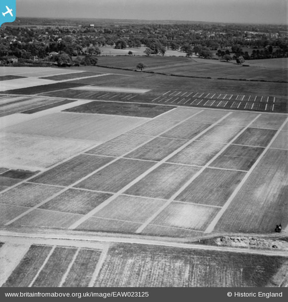
EAW023125 ENGLAND (1949). Fields at Rothamsted Experimental Farm, Rothamsted, 1949
© Copyright OpenStreetMap contributors and licensed by the OpenStreetMap Foundation. 2025. Cartography is licensed as CC BY-SA.
Nearby Images (16)
Details
| Title | [EAW023125] Fields at Rothamsted Experimental Farm, Rothamsted, 1949 |
| Reference | EAW023125 |
| Date | 13-May-1949 |
| Link | |
| Place name | ROTHAMSTED |
| Parish | HARPENDEN RURAL |
| District | |
| Country | ENGLAND |
| Easting / Northing | 512066, 213812 |
| Longitude / Latitude | -0.37420831249492, 51.811246364807 |
| National Grid Reference | TL121138 |
Pins
Be the first to add a comment to this image!


![[EAW023125] Fields at Rothamsted Experimental Farm, Rothamsted, 1949](http://britainfromabove.org.uk/sites/all/libraries/aerofilms-images/public/100x100/EAW/023/EAW023125.jpg)
![[EAW023134] Rothamsted Experimental Farm, Rothamsted, 1949](http://britainfromabove.org.uk/sites/all/libraries/aerofilms-images/public/100x100/EAW/023/EAW023134.jpg)
![[EAW023129] Rothamsted Experimental Farm, Rothamsted, 1949. This image has been produced from a print.](http://britainfromabove.org.uk/sites/all/libraries/aerofilms-images/public/100x100/EAW/023/EAW023129.jpg)
![[EAW023123] Fields at Rothamsted Experimental Farm, Rothamsted, 1949](http://britainfromabove.org.uk/sites/all/libraries/aerofilms-images/public/100x100/EAW/023/EAW023123.jpg)
![[EAW023126] Fields at Rothamsted Experimental Farm, Rothamsted, from the north-east, 1949](http://britainfromabove.org.uk/sites/all/libraries/aerofilms-images/public/100x100/EAW/023/EAW023126.jpg)
![[EAW023121] Fields at Rothamsted Experimental Farm, Rothamsted, 1949. This image was marked by Aerofilms Ltd for photo editing.](http://britainfromabove.org.uk/sites/all/libraries/aerofilms-images/public/100x100/EAW/023/EAW023121.jpg)
![[EAW023124] Fields at Rothamsted Experimental Farm, Rothamsted, 1949. This image was marked by Aerofilms Ltd for photo editing.](http://britainfromabove.org.uk/sites/all/libraries/aerofilms-images/public/100x100/EAW/023/EAW023124.jpg)
![[EAW023133] Fields at Rothamsted Experimental Farm, Rothamsted, 1949. This image has been produced from a print marked by Aerofilms Ltd for photo editing.](http://britainfromabove.org.uk/sites/all/libraries/aerofilms-images/public/100x100/EAW/023/EAW023133.jpg)
![[EAW023127] Rothamsted Experimental Farm, Rothamsted, 1949](http://britainfromabove.org.uk/sites/all/libraries/aerofilms-images/public/100x100/EAW/023/EAW023127.jpg)
![[EAW023128] Fields at Rothamsted Experimental Farm, Rothamsted, 1949. This image was marked by Aerofilms Ltd for photo editing.](http://britainfromabove.org.uk/sites/all/libraries/aerofilms-images/public/100x100/EAW/023/EAW023128.jpg)
![[EAW023130] Fields at Rothamsted Experimental Farm, Rothamsted, 1949. This image has been produced from a print.](http://britainfromabove.org.uk/sites/all/libraries/aerofilms-images/public/100x100/EAW/023/EAW023130.jpg)
![[EAW023122] Fields at Rothamsted Experimental Farm, Rothamsted, 1949. This image has been produced from a print marked by Aerofilms Ltd for photo editing.](http://britainfromabove.org.uk/sites/all/libraries/aerofilms-images/public/100x100/EAW/023/EAW023122.jpg)
![[EAW023131] Fields at Rothamsted Experimental Farm, Rothamsted, 1949. This image has been produced from a print.](http://britainfromabove.org.uk/sites/all/libraries/aerofilms-images/public/100x100/EAW/023/EAW023131.jpg)
![[EAW023132] Fields at Rothamsted Experimental Farm, Rothamsted, 1949. This image has been produced from a print.](http://britainfromabove.org.uk/sites/all/libraries/aerofilms-images/public/100x100/EAW/023/EAW023132.jpg)
![[EAW041170] Rothamsted Experimental Farm, Rothamsted, 1951](http://britainfromabove.org.uk/sites/all/libraries/aerofilms-images/public/100x100/EAW/041/EAW041170.jpg)
![[EAW041169] Rothamsted Experimental Farm, Rothamsted, 1951](http://britainfromabove.org.uk/sites/all/libraries/aerofilms-images/public/100x100/EAW/041/EAW041169.jpg)