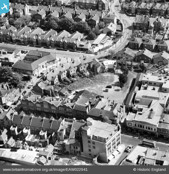
EAW022941 ENGLAND (1949). Manor Lane by the Employment Exchange, Sutton, 1949
© Copyright OpenStreetMap contributors and licensed by the OpenStreetMap Foundation. 2026. Cartography is licensed as CC BY-SA.
Nearby Images (17)
Details
| Title | [EAW022941] Manor Lane by the Employment Exchange, Sutton, 1949 |
| Reference | EAW022941 |
| Date | 6-May-1949 |
| Link | |
| Place name | SUTTON |
| Parish | |
| District | |
| Country | ENGLAND |
| Easting / Northing | 525901, 164395 |
| Longitude / Latitude | -0.19132947489233, 51.364148757287 |
| National Grid Reference | TQ259644 |
Pins

redmist |
Thursday 14th of October 2021 07:51:08 PM | |

Sparky |
Monday 28th of August 2017 09:19:05 AM | |

Falcon |
Sunday 5th of January 2014 11:39:45 AM | |
This one is West Street, George Street is the next one down opposite Manor Lane. |

Mark1973 |
Monday 9th of February 2015 02:35:25 PM |

Falcon |
Sunday 5th of January 2014 11:38:23 AM | |

Falcon |
Sunday 5th of January 2014 11:38:06 AM | |

Falcon |
Sunday 5th of January 2014 11:36:35 AM | |

Falcon |
Sunday 5th of January 2014 11:34:33 AM | |

Falcon |
Sunday 5th of January 2014 11:34:32 AM |


![[EAW022941] Manor Lane by the Employment Exchange, Sutton, 1949](http://britainfromabove.org.uk/sites/all/libraries/aerofilms-images/public/100x100/EAW/022/EAW022941.jpg)
![[EAW022943] Sanitary Appliances Ltd Works and Manor Lane, Sutton, 1949](http://britainfromabove.org.uk/sites/all/libraries/aerofilms-images/public/100x100/EAW/022/EAW022943.jpg)
![[EAW022946] Manor Lane, Lodge Road and the High Street, Sutton, 1949](http://britainfromabove.org.uk/sites/all/libraries/aerofilms-images/public/100x100/EAW/022/EAW022946.jpg)
![[EAW022954] Manor Lane and the High Street, Sutton, 1949](http://britainfromabove.org.uk/sites/all/libraries/aerofilms-images/public/100x100/EAW/022/EAW022954.jpg)
![[EAW022957] Manor Lane, the Drill Hall (TA Centre) on Lenham Road and the High Street, Sutton, 1949](http://britainfromabove.org.uk/sites/all/libraries/aerofilms-images/public/100x100/EAW/022/EAW022957.jpg)
![[EAW022956] Manor Lane and the High Street, Sutton, 1949](http://britainfromabove.org.uk/sites/all/libraries/aerofilms-images/public/100x100/EAW/022/EAW022956.jpg)
![[EAW022942] The High Street and Lodge Road, Sutton, 1949](http://britainfromabove.org.uk/sites/all/libraries/aerofilms-images/public/100x100/EAW/022/EAW022942.jpg)
![[EAW022945] Manor Lane, Lodge Road and the High Street, Sutton, 1949](http://britainfromabove.org.uk/sites/all/libraries/aerofilms-images/public/100x100/EAW/022/EAW022945.jpg)
![[EAW022944] Manor Lane and the High Street, Sutton, 1949](http://britainfromabove.org.uk/sites/all/libraries/aerofilms-images/public/100x100/EAW/022/EAW022944.jpg)
![[EAW022940] Manor Lane by the Employment Exchange and the High Street, Sutton, 1949](http://britainfromabove.org.uk/sites/all/libraries/aerofilms-images/public/100x100/EAW/022/EAW022940.jpg)
![[EPW050017] The town centre, Sutton, 1936. This image has been produced from a print.](http://britainfromabove.org.uk/sites/all/libraries/aerofilms-images/public/100x100/EPW/050/EPW050017.jpg)
![[EPW057033] The High Street, Sutton, 1938](http://britainfromabove.org.uk/sites/all/libraries/aerofilms-images/public/100x100/EPW/057/EPW057033.jpg)
![[EPW001674] Sutton High Street and area, Sutton, 1920](http://britainfromabove.org.uk/sites/all/libraries/aerofilms-images/public/100x100/EPW/001/EPW001674.jpg)
![[EPW028239] The High Street and the town, Sutton, 1929](http://britainfromabove.org.uk/sites/all/libraries/aerofilms-images/public/100x100/EPW/028/EPW028239.jpg)
![[EPW028249] The High Street and environs, Sutton, 1929](http://britainfromabove.org.uk/sites/all/libraries/aerofilms-images/public/100x100/EPW/028/EPW028249.jpg)
![[EPW028245] The High Street, Sutton, 1929](http://britainfromabove.org.uk/sites/all/libraries/aerofilms-images/public/100x100/EPW/028/EPW028245.jpg)
![[EPW011424] Manor Lane, Benhill Avenue and environs, Sutton, 1924. This image has been produced from a print.](http://britainfromabove.org.uk/sites/all/libraries/aerofilms-images/public/100x100/EPW/011/EPW011424.jpg)