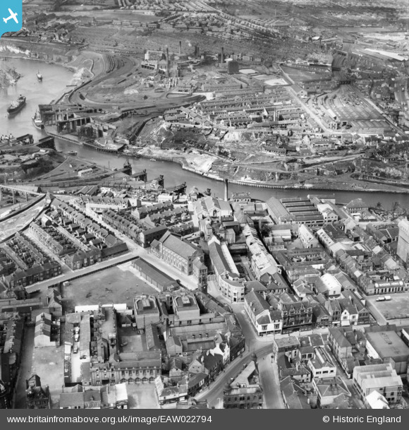
EAW022794 ENGLAND (1949). The Vaux and Associated Breweries Ltd Brewery on Castle Street, Garrison Field, and Wearmouth Colliery, Sunderland, 1949
© Copyright OpenStreetMap contributors and licensed by the OpenStreetMap Foundation. 2026. Cartography is licensed as CC BY-SA.
Nearby Images (17)
Details
| Title | [EAW022794] The Vaux and Associated Breweries Ltd Brewery on Castle Street, Garrison Field, and Wearmouth Colliery, Sunderland, 1949 |
| Reference | EAW022794 |
| Date | 1-May-1949 |
| Link | |
| Place name | SUNDERLAND |
| Parish | |
| District | |
| Country | ENGLAND |
| Easting / Northing | 439369, 557291 |
| Longitude / Latitude | -1.3858870134603, 54.908695887529 |
| National Grid Reference | NZ394573 |
Pins

NickJT |
Saturday 17th of October 2020 08:46:01 PM | |

NickJT |
Saturday 17th of October 2020 08:44:39 PM | |

redmist |
Saturday 26th of September 2020 04:18:16 PM | |

redmist |
Saturday 26th of September 2020 04:17:55 PM | |

redmist |
Saturday 26th of September 2020 04:13:47 PM | |

Sparky |
Monday 28th of August 2017 08:52:50 AM | |

mapmaker |
Wednesday 8th of July 2015 12:26:47 AM | |

mapmaker |
Wednesday 8th of July 2015 12:25:17 AM | |

MB |
Sunday 29th of December 2013 10:35:51 AM | |

MB |
Sunday 29th of December 2013 10:34:55 AM | |

MB |
Sunday 29th of December 2013 10:34:28 AM | |

kevin n |
Monday 23rd of December 2013 03:26:35 PM | |

kevin n |
Monday 23rd of December 2013 03:25:24 PM | |

kevin n |
Monday 23rd of December 2013 03:22:13 PM |


![[EAW022794] The Vaux and Associated Breweries Ltd Brewery on Castle Street, Garrison Field, and Wearmouth Colliery, Sunderland, 1949](http://britainfromabove.org.uk/sites/all/libraries/aerofilms-images/public/100x100/EAW/022/EAW022794.jpg)
![[EAW022797] The Vaux and Associated Breweries Ltd Brewery on Castle Street and environs, Sunderland, 1949. This image has been produced from a print marked by Aerofilms Ltd for photo editing.](http://britainfromabove.org.uk/sites/all/libraries/aerofilms-images/public/100x100/EAW/022/EAW022797.jpg)
![[EAW022793] The Vaux and Associated Breweries Ltd Brewery on Castle Street, Garrison Field, and Wearmouth Colliery, Sunderland, 1949](http://britainfromabove.org.uk/sites/all/libraries/aerofilms-images/public/100x100/EAW/022/EAW022793.jpg)
![[EAW022831] Vaux and Associated Breweries Ltd Brewery on Castle Street, Garrison Field and Wearmouth Colliery, Sunderland, 1949](http://britainfromabove.org.uk/sites/all/libraries/aerofilms-images/public/100x100/EAW/022/EAW022831.jpg)
![[EAW022795] The Vaux and Associated Breweries Ltd Brewery on Castle Street, Garrison Field, and Wearmouth Bridge, Sunderland, 1949](http://britainfromabove.org.uk/sites/all/libraries/aerofilms-images/public/100x100/EAW/022/EAW022795.jpg)
![[EAW022796] The Vaux and Associated Breweries Ltd Brewery on Castle Street, Garrison Field, and Wearmouth Bridge, Sunderland, 1949](http://britainfromabove.org.uk/sites/all/libraries/aerofilms-images/public/100x100/EAW/022/EAW022796.jpg)
![[EAW022830] Vaux and Associated Breweries Ltd Brewery, Garrison Field and Wearmouth Bridge, Sunderland, 1949](http://britainfromabove.org.uk/sites/all/libraries/aerofilms-images/public/100x100/EAW/022/EAW022830.jpg)
![[EAW022798] The Vaux and Associated Breweries Ltd Brewery on Castle Street and environs, Sunderland, 1949. This image has been produced from a print marked by Aerofilms Ltd for photo editing.](http://britainfromabove.org.uk/sites/all/libraries/aerofilms-images/public/100x100/EAW/022/EAW022798.jpg)
![[EPW020544] The Wearmouth Bridge and Lambton and Hetton Staiths, Sunderland, from the east, 1928](http://britainfromabove.org.uk/sites/all/libraries/aerofilms-images/public/100x100/EPW/020/EPW020544.jpg)
![[EPW020542] Lambton and Hetton Staiths, Sunderland, 1928](http://britainfromabove.org.uk/sites/all/libraries/aerofilms-images/public/100x100/EPW/020/EPW020542.jpg)
![[EPW010360] Robson and Sons Ltd Queen Street Mill and the Wearmouth Bridges, Sunderland, 1924. This image has been produced from a copy-negative.](http://britainfromabove.org.uk/sites/all/libraries/aerofilms-images/public/100x100/EPW/010/EPW010360.jpg)
![[EPW020540] Lambton and Hetton Staiths, Sunderland, 1928](http://britainfromabove.org.uk/sites/all/libraries/aerofilms-images/public/100x100/EPW/020/EPW020540.jpg)
![[EAW001028] Monkwearmouth Goods Station, the River Wear and the surrounding industrial and residential area, Sunderland, 1946](http://britainfromabove.org.uk/sites/all/libraries/aerofilms-images/public/100x100/EAW/001/EAW001028.jpg)
![[EPW051127] Wearmouth Bridge and environs, Sunderland, 1936. This image has been produced from copy-negative.](http://britainfromabove.org.uk/sites/all/libraries/aerofilms-images/public/100x100/EPW/051/EPW051127.jpg)
![[EAW001027] Wearmouth Bridge and the surrounding industrial and residential area, Sunderland, 1946](http://britainfromabove.org.uk/sites/all/libraries/aerofilms-images/public/100x100/EAW/001/EAW001027.jpg)
![[EPW020545] Lambton and Hetton Staiths, Sunderland, 1928](http://britainfromabove.org.uk/sites/all/libraries/aerofilms-images/public/100x100/EPW/020/EPW020545.jpg)
![[EPW020543] The Wearmouth Colliery and Lambton and Hetton Staiths, Sunderland, 1928](http://britainfromabove.org.uk/sites/all/libraries/aerofilms-images/public/100x100/EPW/020/EPW020543.jpg)