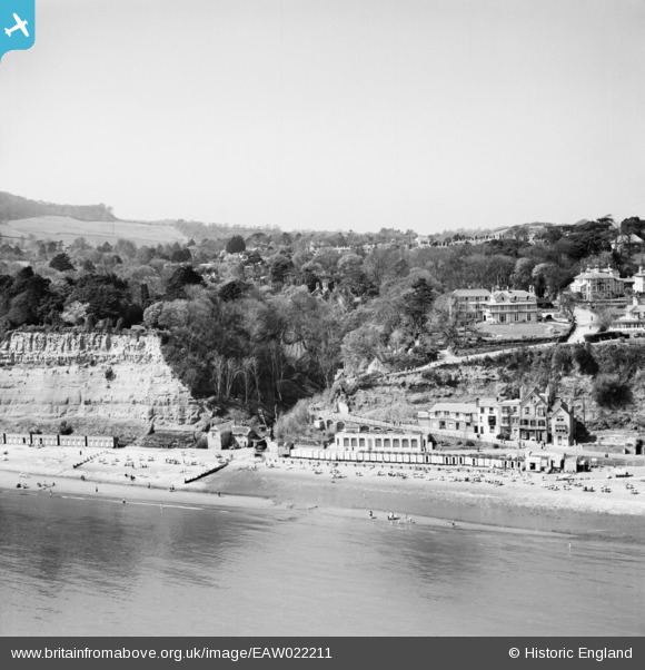
EAW022211 ENGLAND (1949). The mouth of the Shanklin Chine and the seafront, Shanklin, from the east, 1949
© Copyright OpenStreetMap contributors and licensed by the OpenStreetMap Foundation. 2026. Cartography is licensed as CC BY-SA.
Nearby Images (23)
Details
| Title | [EAW022211] The mouth of the Shanklin Chine and the seafront, Shanklin, from the east, 1949 |
| Reference | EAW022211 |
| Date | 17-April-1949 |
| Link | |
| Place name | SHANKLIN |
| Parish | SHANKLIN |
| District | |
| Country | ENGLAND |
| Easting / Northing | 458554, 81080 |
| Longitude / Latitude | -1.1720903593697, 50.625893961601 |
| National Grid Reference | SZ586811 |
Pins

Kentishman |
Wednesday 12th of August 2015 08:22:45 PM | |

Adam |
Sunday 26th of July 2015 06:50:14 PM | |

Adam |
Sunday 26th of July 2015 06:49:39 PM | |

Al |
Tuesday 11th of March 2014 12:34:16 AM |
User Comment Contributions

Kentishman |
Wednesday 12th of August 2015 08:26:04 PM | |

Al |
Tuesday 11th of March 2014 12:34:46 AM |


![[EAW022211] The mouth of the Shanklin Chine and the seafront, Shanklin, from the east, 1949](http://britainfromabove.org.uk/sites/all/libraries/aerofilms-images/public/100x100/EAW/022/EAW022211.jpg)
![[EPW039647] The seafront and the town, Shanklin, 1932. This image was marked by Aerofilms Ltd for photo editing.](http://britainfromabove.org.uk/sites/all/libraries/aerofilms-images/public/100x100/EPW/039/EPW039647.jpg)
![[EAW015237] Beach huts on the Esplanade and the Shanklin Savoy Hotel off Chine Avenue, Shanklin, 1948](http://britainfromabove.org.uk/sites/all/libraries/aerofilms-images/public/100x100/EAW/015/EAW015237.jpg)
![[EAW015236] The Esplanade and Shanklin Savoy Hotel off Chine Avenue, Shanklin, 1948](http://britainfromabove.org.uk/sites/all/libraries/aerofilms-images/public/100x100/EAW/015/EAW015236.jpg)
![[EAW015238] The Esplanade and the Shanklin Savoy Hotel off Chine Avenue, Shanklin, 1948](http://britainfromabove.org.uk/sites/all/libraries/aerofilms-images/public/100x100/EAW/015/EAW015238.jpg)
![[EPW022918] St Saviour-on-the-Cliff Church and the seafront, Shanklin, 1928](http://britainfromabove.org.uk/sites/all/libraries/aerofilms-images/public/100x100/EPW/022/EPW022918.jpg)
![[EAW015234] The Shanklin Savoy Hotel off Chine Avenue, Shanklin, 1948. This image has been produced from a damaged negative.](http://britainfromabove.org.uk/sites/all/libraries/aerofilms-images/public/100x100/EAW/015/EAW015234.jpg)
![[EPW024583] The Shanklin Chine and Everton House, Shanklin, 1928](http://britainfromabove.org.uk/sites/all/libraries/aerofilms-images/public/100x100/EPW/024/EPW024583.jpg)
![[EAW015235] The Shanklin Savoy Hotel off Chine Avenue, Shanklin, 1948. This image has been produced from a damaged negative.](http://britainfromabove.org.uk/sites/all/libraries/aerofilms-images/public/100x100/EAW/015/EAW015235.jpg)
![[EAW015240] The Shanklin Savoy Hotel, Shanklin, 1948](http://britainfromabove.org.uk/sites/all/libraries/aerofilms-images/public/100x100/EAW/015/EAW015240.jpg)
![[EAW015239] The Shanklin Savoy Hotel, Shanklin, 1948](http://britainfromabove.org.uk/sites/all/libraries/aerofilms-images/public/100x100/EAW/015/EAW015239.jpg)
![[EPW024582] The mouth of the Shanklin Chine, Shanklin, 1928](http://britainfromabove.org.uk/sites/all/libraries/aerofilms-images/public/100x100/EPW/024/EPW024582.jpg)
![[EPW022920] The Esplanade, Shanklin, 1928](http://britainfromabove.org.uk/sites/all/libraries/aerofilms-images/public/100x100/EPW/022/EPW022920.jpg)
![[EPW022914] Beach huts at Appley Steps, Shanklin, 1928](http://britainfromabove.org.uk/sites/all/libraries/aerofilms-images/public/100x100/EPW/022/EPW022914.jpg)
![[EPW039646] Hope Beach and the Esplanade, Shanklin, 1932](http://britainfromabove.org.uk/sites/all/libraries/aerofilms-images/public/100x100/EPW/039/EPW039646.jpg)
![[EAW038586] The town and the seafront, Shanklin, 1951. This image has been produced from a print.](http://britainfromabove.org.uk/sites/all/libraries/aerofilms-images/public/100x100/EAW/038/EAW038586.jpg)
![[EAW022214] Shanklin Pier and the town, Shanklin, from the east, 1949. This image has been produced from a print.](http://britainfromabove.org.uk/sites/all/libraries/aerofilms-images/public/100x100/EAW/022/EAW022214.jpg)
![[EPW043003] The Esplanade, East Cliff Promenade and environs, Shanklin, from the south-east, 1933](http://britainfromabove.org.uk/sites/all/libraries/aerofilms-images/public/100x100/EPW/043/EPW043003.jpg)
![[EAW022213] Shanklin Pier and the town, Shanklin, 1949. This image has been produced from a print.](http://britainfromabove.org.uk/sites/all/libraries/aerofilms-images/public/100x100/EAW/022/EAW022213.jpg)
![[EAW028276] The pier and town, Shanklin, from the south-east, 1950](http://britainfromabove.org.uk/sites/all/libraries/aerofilms-images/public/100x100/EAW/028/EAW028276.jpg)
![[EPW024580] St Saviour's Church and environs, Shanklin, 1928](http://britainfromabove.org.uk/sites/all/libraries/aerofilms-images/public/100x100/EPW/024/EPW024580.jpg)
![[EAW038585] Shanklin Pier, Shanklin, 1951. This image has been produced from a print.](http://britainfromabove.org.uk/sites/all/libraries/aerofilms-images/public/100x100/EAW/038/EAW038585.jpg)
![[EAW015241] Shanklin Pier and the town, Shanklin, from the south-east, 1948](http://britainfromabove.org.uk/sites/all/libraries/aerofilms-images/public/100x100/EAW/015/EAW015241.jpg)
