
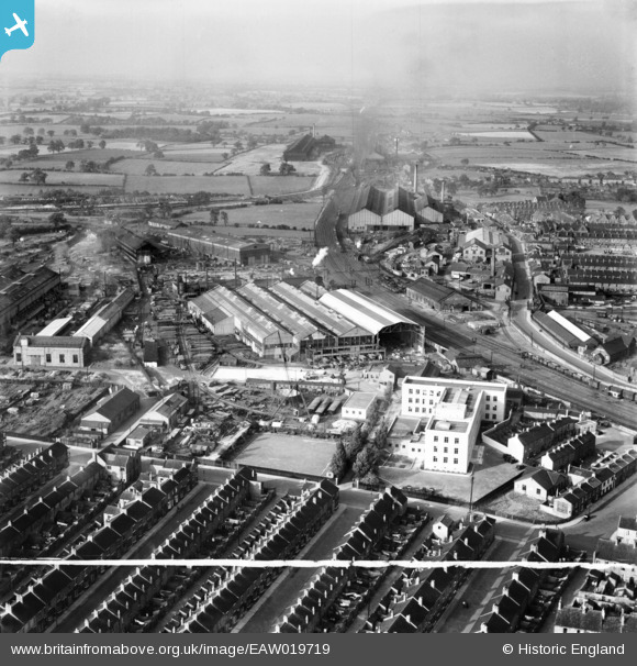
EAW019719 ENGLAND (1948). The Whessoe Engineering Works and environs, Darlington, from the south, 1948. This image was marked by Aerofilms Ltd for photo editing.
© Copyright OpenStreetMap contributors and licensed by the OpenStreetMap Foundation. 2026. Cartography is licensed as CC BY-SA.
Nearby Images (17)
EAW019719

EAW019724

EAW019725

EPW062174

EPW062179

EPW062180

EPW031544

EPW062183

EPW029509

EPW062173

EAW019728

EAW019727

EAW019726A

EAW019726

EPW062182

EPW031540

EPW031539

Details
| Title | [EAW019719] The Whessoe Engineering Works and environs, Darlington, from the south, 1948. This image was marked by Aerofilms Ltd for photo editing. |
| Reference | EAW019719 |
| Date | 6-October-1948 |
| Link | |
| Place name | DARLINGTON |
| Parish | |
| District | |
| Country | ENGLAND |
| Easting / Northing | 428586, 515853 |
| Longitude / Latitude | -1.5581525804811, 54.537011178136 |
| National Grid Reference | NZ286159 |
Pins
 |

J May |
Wednesday 20th of May 2020 05:03:47 PM |
|
1980-f |
Friday 23rd of August 2019 09:39:31 PM | |
|
1980-f |
Friday 23rd of August 2019 09:37:21 PM | |
|
John W |
Sunday 19th of March 2017 07:16:12 PM | |
|
John W |
Sunday 19th of March 2017 07:14:48 PM | |
|
John W |
Sunday 19th of March 2017 07:03:24 PM | |
|
1980-f |
Sunday 19th of March 2017 06:41:49 PM | |
|
1980-f |
Sunday 19th of March 2017 06:39:04 PM | |
|
1980-f |
Sunday 19th of March 2017 06:36:12 PM | |
|
Fantasma |
Monday 10th of March 2014 10:09:12 PM | |
|
Chells809 |
Thursday 2nd of January 2014 09:51:45 PM | |
|
Chells809 |
Thursday 2nd of January 2014 09:51:03 PM | |
|
Chells809 |
Thursday 2nd of January 2014 09:50:00 PM | |
|
Chells809 |
Thursday 2nd of January 2014 09:49:22 PM | |
|
Chells809 |
Thursday 2nd of January 2014 09:48:05 PM | |
|
Chells809 |
Thursday 2nd of January 2014 09:47:29 PM | |
|
Chells809 |
Thursday 2nd of January 2014 09:46:58 PM | |
|
Chells809 |
Thursday 2nd of January 2014 09:46:26 PM |