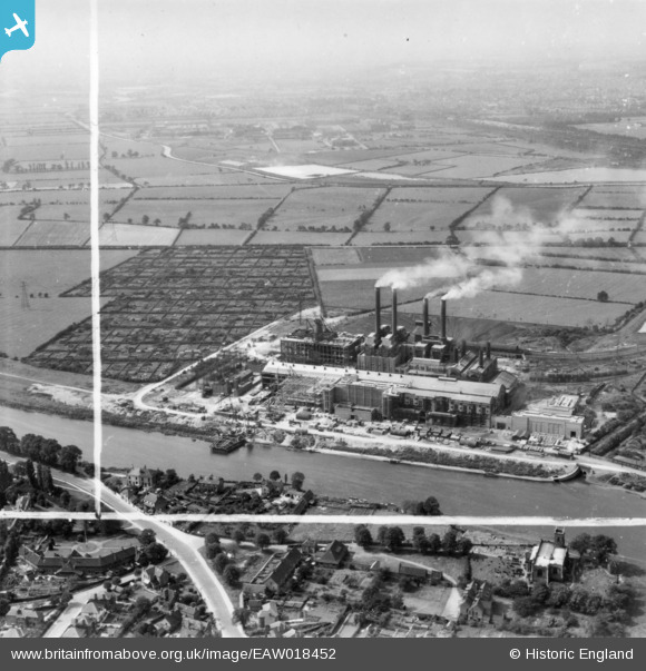
EAW018452 ENGLAND (1948). The North Wilford Power Station under construction, Nottingham, from the north-east, 1948. This image has been produced from a print marked by Aerofilms Ltd for photo editing.
© Copyright OpenStreetMap contributors and licensed by the OpenStreetMap Foundation. 2026. Cartography is licensed as CC BY-SA.
Nearby Images (41)
Details
| Title | [EAW018452] The North Wilford Power Station under construction, Nottingham, from the north-east, 1948. This image has been produced from a print marked by Aerofilms Ltd for photo editing. |
| Reference | EAW018452 |
| Date | 31-August-1948 |
| Link | |
| Place name | NOTTINGHAM |
| Parish | |
| District | |
| Country | ENGLAND |
| Easting / Northing | 456514, 337626 |
| Longitude / Latitude | -1.1591115242657, 52.932741490032 |
| National Grid Reference | SK565376 |
Pins
Be the first to add a comment to this image!


![[EAW018452] The North Wilford Power Station under construction, Nottingham, from the north-east, 1948. This image has been produced from a print marked by Aerofilms Ltd for photo editing.](http://britainfromabove.org.uk/sites/all/libraries/aerofilms-images/public/100x100/EAW/018/EAW018452.jpg)
![[EAW009126] Wilford Power Station and environs, Nottingham, from the east, 1947](http://britainfromabove.org.uk/sites/all/libraries/aerofilms-images/public/100x100/EAW/009/EAW009126.jpg)
![[EAW046573] Wilford Power Station, Nottingham, from the east, 1952. This image was marked by Aerofilms Ltd for photo editing.](http://britainfromabove.org.uk/sites/all/libraries/aerofilms-images/public/100x100/EAW/046/EAW046573.jpg)
![[EAW009127] Wilford Power Station and environs, Nottingham, from the east, 1947](http://britainfromabove.org.uk/sites/all/libraries/aerofilms-images/public/100x100/EAW/009/EAW009127.jpg)
![[EAW009124] Wilford Power Station and environs, Nottingham, from the south-east, 1947](http://britainfromabove.org.uk/sites/all/libraries/aerofilms-images/public/100x100/EAW/009/EAW009124.jpg)
![[EAW018456] The North Wilford Power Station under construction, Nottingham, from the east, 1948. This image was marked by Aerofilms Ltd for photo editing.](http://britainfromabove.org.uk/sites/all/libraries/aerofilms-images/public/100x100/EAW/018/EAW018456.jpg)
![[EAW009125] Wilford, Wilford Power Station and environs, Nottingham, from the east, 1947](http://britainfromabove.org.uk/sites/all/libraries/aerofilms-images/public/100x100/EAW/009/EAW009125.jpg)
![[EAW018451] The North Wilford Power Station under construction, Nottingham, from the south-east, 1948. This image has been produced from a print marked by Aerofilms Ltd for photo editing.](http://britainfromabove.org.uk/sites/all/libraries/aerofilms-images/public/100x100/EAW/018/EAW018451.jpg)
![[EAW009119] Wilford Power Station, Nottingham, from the east, 1947](http://britainfromabove.org.uk/sites/all/libraries/aerofilms-images/public/100x100/EAW/009/EAW009119.jpg)
![[EAW009117] Wilford Power Station, Nottingham, from the east, 1947](http://britainfromabove.org.uk/sites/all/libraries/aerofilms-images/public/100x100/EAW/009/EAW009117.jpg)
![[EAW009118] Wilford Power Station, Nottingham, from the east, 1947](http://britainfromabove.org.uk/sites/all/libraries/aerofilms-images/public/100x100/EAW/009/EAW009118.jpg)
![[EAW009116] Wilford Power Station, Nottingham, from the east, 1947](http://britainfromabove.org.uk/sites/all/libraries/aerofilms-images/public/100x100/EAW/009/EAW009116.jpg)
![[EAW018454] The North Wilford Power Station under construction, Nottingham, from the east, 1948. This image has been produced from a damaged negative.](http://britainfromabove.org.uk/sites/all/libraries/aerofilms-images/public/100x100/EAW/018/EAW018454.jpg)
![[EAW018461] The North Wilford Power Station under construction, Nottingham, 1948. This image was marked by Aerofilms Ltd for photo editing.](http://britainfromabove.org.uk/sites/all/libraries/aerofilms-images/public/100x100/EAW/018/EAW018461.jpg)
![[EAW033486] Wilford North Power Station, Nottingham, 1950](http://britainfromabove.org.uk/sites/all/libraries/aerofilms-images/public/100x100/EAW/033/EAW033486.jpg)
![[EAW046572] Wilford Power Station, Nottingham, 1952. This image was marked by Aerofilms Ltd for photo editing.](http://britainfromabove.org.uk/sites/all/libraries/aerofilms-images/public/100x100/EAW/046/EAW046572.jpg)
![[EAW046570] Wilford Power Station, Nottingham, 1952. This image was marked by Aerofilms Ltd for photo editing.](http://britainfromabove.org.uk/sites/all/libraries/aerofilms-images/public/100x100/EAW/046/EAW046570.jpg)
![[EAW033484] Wilford North Power Station, Nottingham, 1950](http://britainfromabove.org.uk/sites/all/libraries/aerofilms-images/public/100x100/EAW/033/EAW033484.jpg)
![[EAW033477] Wilford North Power Station, Nottingham, 1950. This image was marked by Aerofilms Ltd for photo editing.](http://britainfromabove.org.uk/sites/all/libraries/aerofilms-images/public/100x100/EAW/033/EAW033477.jpg)
![[EAW046576] Wilford Power Station, Nottingham, 1952](http://britainfromabove.org.uk/sites/all/libraries/aerofilms-images/public/100x100/EAW/046/EAW046576.jpg)
![[EAW033480] Wilford North Power Station, Nottingham, 1950. This image was marked by Aerofilms Ltd for photo editing.](http://britainfromabove.org.uk/sites/all/libraries/aerofilms-images/public/100x100/EAW/033/EAW033480.jpg)
![[EAW018453] The North Wilford Power Station under construction, Nottingham, 1948. This image has been produced from a print marked by Aerofilms Ltd for photo editing.](http://britainfromabove.org.uk/sites/all/libraries/aerofilms-images/public/100x100/EAW/018/EAW018453.jpg)
![[EAW033483] Wilford North Power Station, Nottingham, 1950](http://britainfromabove.org.uk/sites/all/libraries/aerofilms-images/public/100x100/EAW/033/EAW033483.jpg)
![[EAW033478] Wilford North Power Station and environs, Nottingham, 1950. This image was marked by Aerofilms Ltd for photo editing.](http://britainfromabove.org.uk/sites/all/libraries/aerofilms-images/public/100x100/EAW/033/EAW033478.jpg)
![[EAW018457] The North Wilford Power Station under construction, Nottingham, 1948. This image was marked by Aerofilms Ltd for photo editing.](http://britainfromabove.org.uk/sites/all/libraries/aerofilms-images/public/100x100/EAW/018/EAW018457.jpg)
![[EAW018459] The North Wilford Power Station under construction, Nottingham, 1948. This image was marked by Aerofilms Ltd for photo editing.](http://britainfromabove.org.uk/sites/all/libraries/aerofilms-images/public/100x100/EAW/018/EAW018459.jpg)
![[EAW033481] Wilford North Power Station, Nottingham, 1950. This image was marked by Aerofilms Ltd for photo editing.](http://britainfromabove.org.uk/sites/all/libraries/aerofilms-images/public/100x100/EAW/033/EAW033481.jpg)
![[EAW018460] The North Wilford Power Station under construction, Nottingham, 1948. This image was marked by Aerofilms Ltd for photo editing.](http://britainfromabove.org.uk/sites/all/libraries/aerofilms-images/public/100x100/EAW/018/EAW018460.jpg)
![[EAW046575] Wilford Power Station, Nottingham, 1952](http://britainfromabove.org.uk/sites/all/libraries/aerofilms-images/public/100x100/EAW/046/EAW046575.jpg)
![[EAW033487] Wilford North Power Station, Nottingham, 1950. This image was marked by Aerofilms Ltd for photo editing.](http://britainfromabove.org.uk/sites/all/libraries/aerofilms-images/public/100x100/EAW/033/EAW033487.jpg)
![[EAW046571] Wilford Power Station, Nottingham, 1952. This image was marked by Aerofilms Ltd for photo editing.](http://britainfromabove.org.uk/sites/all/libraries/aerofilms-images/public/100x100/EAW/046/EAW046571.jpg)
![[EAW046574] Wilford Power Station, Nottingham, 1952. This image was marked by Aerofilms Ltd for photo editing.](http://britainfromabove.org.uk/sites/all/libraries/aerofilms-images/public/100x100/EAW/046/EAW046574.jpg)
![[EPW021043] Wilford Power Station, Clifton Colliery and St Wilfrid's Church, Nottingham, 1928](http://britainfromabove.org.uk/sites/all/libraries/aerofilms-images/public/100x100/EPW/021/EPW021043.jpg)
![[EAW046569] Wilford Power Station, Nottingham, 1952](http://britainfromabove.org.uk/sites/all/libraries/aerofilms-images/public/100x100/EAW/046/EAW046569.jpg)
![[EAW018458] The North Wilford Power Station under construction, Nottingham, 1948. This image was marked by Aerofilms Ltd for photo editing.](http://britainfromabove.org.uk/sites/all/libraries/aerofilms-images/public/100x100/EAW/018/EAW018458.jpg)
![[EAW009122] Wilford Power Station and environs, Nottingham, 1947](http://britainfromabove.org.uk/sites/all/libraries/aerofilms-images/public/100x100/EAW/009/EAW009122.jpg)
![[EAW018462] The North Wilford Power Station under construction, Nottingham, 1948](http://britainfromabove.org.uk/sites/all/libraries/aerofilms-images/public/100x100/EAW/018/EAW018462.jpg)
![[EAW033482] Wilford North Power Station, Nottingham, 1950. This image was marked by Aerofilms Ltd for photo editing.](http://britainfromabove.org.uk/sites/all/libraries/aerofilms-images/public/100x100/EAW/033/EAW033482.jpg)
![[EAW018455] The North Wilford Power Station under construction, Nottingham, 1948. This image was marked by Aerofilms Ltd for photo editing.](http://britainfromabove.org.uk/sites/all/libraries/aerofilms-images/public/100x100/EAW/018/EAW018455.jpg)
![[EAW033485] Wilford North Power Station, Nottingham, 1950. This image was marked by Aerofilms Ltd for photo editing.](http://britainfromabove.org.uk/sites/all/libraries/aerofilms-images/public/100x100/EAW/033/EAW033485.jpg)
![[EAW009123] Wilford Power Station and environs, Nottingham, from the south-west, 1947](http://britainfromabove.org.uk/sites/all/libraries/aerofilms-images/public/100x100/EAW/009/EAW009123.jpg)