© Copyright OpenStreetMap contributors and licensed by the OpenStreetMap Foundation. 2026. Cartography is licensed as CC BY-SA.
Details
| Title |
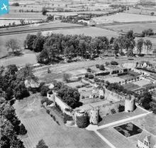
[EAW016519] Barnwell Castle, Barnwell, 1948 |
| Reference |
EAW016519 |
| Date |
9-November-1948 |
| Link |
|
| Place name |
BARNWELL |
| Parish |
BARNWELL |
| District |
|
| Country |
ENGLAND |
| Easting / Northing |
504854, 285288 |
| Longitude / Latitude |
-0.45674867929694, 52.455095037022 |
| National Grid Reference |
TL049853 |
Pins
 Railway- opened 1845.
originally London & Birmingham Railway
later Northampton and Peterborough Branch of L&NWR
finally London Midland Region of British Railways.
Closed 1964 to passenger traffic. Iron Ore trains continued to use the line until 1966 with through freight traffic finally being withdrawn by British Rail in 1972.
Barnwell Station was off the image, to the left.
The main station building was added in 1884 for use by members of the Royal family when visiting Barnwell Manor, home of the Duke of Gloucester. The main station building has been re-errected at Wansford Station on the Nene Valley Steam Railway.
.
|

totoro |
Wednesday 2nd of July 2014 09:44:57 PM |
 Barnwell Brook |

totoro |
Wednesday 2nd of July 2014 09:06:47 PM |
 Barnwell Castle - 6 Well Lane, Barnwell, Northamptonshire PE8 5PS
Grade 1 listed building and scheduled monument - English Heritage Building ID: 232573
The castle is privately owned and access is not permitted.
Monument listing - Formal gardens to Barnwell Castle, laid out from 1913 to the 1920s by Horace Czarnikov, incorporating a raised walk constructed circa 1613 by Thomas Drew.
Castle Listing:
Castle. Built about 1266 by Berenger Le Moyne; some building work may have taken place within the castle during C16:-
In 1568, Sir Edward Montagu founded a Tudor manor house, in the outer court and demolished all the buildings within the courtyard.
Entrance front, to east, has gate-house, to far left of curtain wall, with flanking semi-circular towers.
The towers and curtain walls were originally
probably higher and would have had a castellated parapet. The building date of 1266 is derived from a Jury statement of 1276 which records that Berenger Le Moyne had built a castle 10 years earlier.
The castle was probably used as a farmyard during C18 and C19 with access through the break in the west curtain wall. |

totoro |
Wednesday 2nd of July 2014 09:01:29 PM |
 Gipsy Lane (track) |

totoro |
Wednesday 2nd of July 2014 09:00:13 PM |
 White Lodge |

totoro |
Wednesday 2nd of July 2014 08:59:40 PM |
 "Gardeners" |

totoro |
Wednesday 2nd of July 2014 08:57:31 PM |
 Armston Road |

totoro |
Wednesday 2nd of July 2014 08:56:11 PM |
User Comment Contributions


![[EAW016519] Barnwell Castle, Barnwell, 1948](http://britainfromabove.org.uk/sites/all/libraries/aerofilms-images/public/100x100/EAW/016/EAW016519.jpg)
![[EAW016517] Barnwell Castle, Barnwell, 1948. This image has been produced from a print.](http://britainfromabove.org.uk/sites/all/libraries/aerofilms-images/public/100x100/EAW/016/EAW016517.jpg)
![[EAW013676] Barnwell Castle, Barnwell, 1948](http://britainfromabove.org.uk/sites/all/libraries/aerofilms-images/public/100x100/EAW/013/EAW013676.jpg)
![[EAW015475] Barnwell Castle and Manor, Barnwell, 1948. This image has been produced from a print.](http://britainfromabove.org.uk/sites/all/libraries/aerofilms-images/public/100x100/EAW/015/EAW015475.jpg)
![[EAW016521] Barnwell Castle, Barnwell, 1948. This image has been produced from a print.](http://britainfromabove.org.uk/sites/all/libraries/aerofilms-images/public/100x100/EAW/016/EAW016521.jpg)
![[EAW016520] Barnwell Castle and Manor, Barnwell, 1948](http://britainfromabove.org.uk/sites/all/libraries/aerofilms-images/public/100x100/EAW/016/EAW016520.jpg)
![[EAW013678] Barnwell Castle, Barnwell, 1948. This image has been affected by flare.](http://britainfromabove.org.uk/sites/all/libraries/aerofilms-images/public/100x100/EAW/013/EAW013678.jpg)
![[EAW015474] Barnwell Castle and Manor, Barnwell, 1948. This image has been produced from a print.](http://britainfromabove.org.uk/sites/all/libraries/aerofilms-images/public/100x100/EAW/015/EAW015474.jpg)
![[EAW015476] Barnwell Castle and Manor, Barnwell, 1948. This image has been produced from a print.](http://britainfromabove.org.uk/sites/all/libraries/aerofilms-images/public/100x100/EAW/015/EAW015476.jpg)
![[EAW013677] Barnwell Castle, Barnwell, 1948. This image has been affected by flare.](http://britainfromabove.org.uk/sites/all/libraries/aerofilms-images/public/100x100/EAW/013/EAW013677.jpg)
![[EAW016518] Barnwell Manor and Castle, Barnwell, 1948. This image has been produced from a print.](http://britainfromabove.org.uk/sites/all/libraries/aerofilms-images/public/100x100/EAW/016/EAW016518.jpg)
