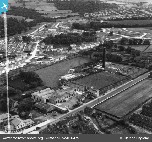
EAW016475 ENGLAND (1948). Holybrook Mills at Greengates, Bradford, 1948. This image has been produced from a print marked by Aerofilms Ltd for photo editing.
© Copyright OpenStreetMap contributors and licensed by the OpenStreetMap Foundation. 2025. Cartography is licensed as CC BY-SA.
Nearby Images (7)
Details
| Title | [EAW016475] Holybrook Mills at Greengates, Bradford, 1948. This image has been produced from a print marked by Aerofilms Ltd for photo editing. |
| Reference | EAW016475 |
| Date | 9-June-1948 |
| Link | |
| Place name | BRADFORD |
| Parish | |
| District | |
| Country | ENGLAND |
| Easting / Northing | 419059, 437025 |
| Longitude / Latitude | -1.7104004557742, 53.82892819139 |
| National Grid Reference | SE191370 |
Pins

redmist |
Sunday 14th of November 2021 06:11:38 PM | |

redmist |
Sunday 14th of November 2021 04:56:02 PM | |

Val |
Saturday 26th of November 2016 02:46:23 PM | |

Val |
Saturday 26th of November 2016 02:46:05 PM |


![[EAW016475] Holybrook Mills at Greengates, Bradford, 1948. This image has been produced from a print marked by Aerofilms Ltd for photo editing.](http://britainfromabove.org.uk/sites/all/libraries/aerofilms-images/public/100x100/EAW/016/EAW016475.jpg)
![[EAW016479] Holybrook Mills at Greengates, Bradford, 1948. This image has been produced from a print marked by Aerofilms Ltd for photo editing.](http://britainfromabove.org.uk/sites/all/libraries/aerofilms-images/public/100x100/EAW/016/EAW016479.jpg)
![[EAW016476] Holybrook Mills at Greengates, Bradford, 1948. This image has been produced from a print marked by Aerofilms Ltd for photo editing.](http://britainfromabove.org.uk/sites/all/libraries/aerofilms-images/public/100x100/EAW/016/EAW016476.jpg)
![[EAW016474] Holybrook Mills at Greengates, Bradford, 1948. This image has been produced from a print marked by Aerofilms Ltd for photo editing.](http://britainfromabove.org.uk/sites/all/libraries/aerofilms-images/public/100x100/EAW/016/EAW016474.jpg)
![[EAW016478] Holybrook Mills at Greengates, Bradford, from the north-east, 1948. This image has been produced from a print marked by Aerofilms Ltd for photo editing.](http://britainfromabove.org.uk/sites/all/libraries/aerofilms-images/public/100x100/EAW/016/EAW016478.jpg)
![[EAW016477] Holybrook Mills at Greengates, Bradford, 1948. This image has been produced from a print marked by Aerofilms Ltd for photo editing.](http://britainfromabove.org.uk/sites/all/libraries/aerofilms-images/public/100x100/EAW/016/EAW016477.jpg)
![[EAW016480] Holybrook Mills at Greengates, Bradford, from the west, 1948. This image has been produced from a print marked by Aerofilms Ltd for photo editing.](http://britainfromabove.org.uk/sites/all/libraries/aerofilms-images/public/100x100/EAW/016/EAW016480.jpg)